world.wikisort.org - India
Korba is a city and an industrial area in Korba District in the Indian state of Chhattisgarh. Korba was erstwhile part of Bilaspur District before 25 May 1998 later that Korba was made a separate District for ease of administration but it is still under Bilaspur Division. Korba is called power capital of Chhattisgarh due to its Coal reserves and Industrial base for multiple thermal based power plants from Public sector like NTPC Limited, CSEB from State of Chhattisgarh as well as from private sector apart from Power plants Korba has the Asia's second largest and India's largest open cast coal mine in Gevra area of Korba Coalfield. Korba produces 140 Million tons of coal every year which accounts for 17% of Country's total coal production and 85% of Chhattisgarh Coal production. BALCO Private owned Aluminium producer has its smelter Aluminium Plant in Korba. Here mainly the protected tribal tribe Korwa (Pahadi Korwa) resides. Korba district is blessed by lush green forests from all around, a large population of tribals is found here. The tribals here prefer to live in harmony with the environment in the forest area due to which they have retained their distinctive cultural characteristics and traditional practices.
Korba | |
|---|---|
Power City
Industrial Capital of Chhattisgarh | |
|
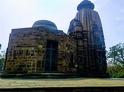
From top, left to right: Palm mall, CSEB west Chimney and Cooling tower , BALCO aluminium plant, Dumpers at Gevra coalmines, Deopahri Forest range ,Transport Nagar road, Korba Urjadhani Logo, Pali Ancient shiv mandir, Chaiturgarh hills, Chaiturgarh temple, Sunset in Satrenga | |
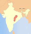
 Korba Location in Chhattisgarh, India  Korba Korba (India) | |
| Coordinates: 22.35°N 82.68°E | |
| country | India |
| State | Chhattisgarh |
| District | Korba |
| Named for | Pahadi korwas |
| Government | |
| • Body | Nagar Nigam Korba |
| • Mayor | Rajkishor Prasad (INC) |
| • President | Shyam Sunder Soni (INC)[1] |
| Elevation | 316 m (1,037 ft) |
| Population (Urban 2011) | |
| • Total | 365,253 |
| • Rank | 126th |
| Demonym | Korbites |
| Time zone | UTC+5:30 (IST) |
| PIN | 495677 (Korba)[2] |
| Area code | 7759 |
| Vehicle registration | CG-12 |
| Sex ratio | 927 ♂/♀ |
| Website | www |
Geography
Korba is located at 22.35°N 82.68°E.[3] It has an average elevation of 252 m (827 ft). As of 2011[update] India census,[4] Korba city had a population of 365,253. Korba City is a part of the Korba District which was formed on 25 May 1998. The forest area cover of Korba is 4,187.375 km2 (1,616.755 sq mi). There are 17 police stations in Korba and it contains five blocks.[5]
Economy
[6][7][8]Korba Super Thermal Power Plant of NTPC is located at Jamanipali area. It receives coal from Gevra and Kusmunda mines and source of water for the power plant is Hasdeo River.[9] Korba Thermal Power Station is owned and operated by National Thermal Power Corporation.[10][11] There are more small Power Plant near city like Hasdeo Thermal Power Station, Dr Shyama Prasad Mukharjee Thermal Power Station and Lanco Amarkantak Power Plant.
Bharat Aluminium Company has plant which is one of the Asia's largest aluminium production industries. In 2009, chimney under construction by Gannon Dunkerley & Company at the Balco smelter collapsed killing 49 workers and GDCL management have been accused of negligence in the incident.[12][13][14][15]
Government and jurisdiction
Korba is headquarter of Korba district. Korba City has been a metropolitan municipality with a mayor-council form of government.
Korba (Lok Sabha constituency) is a Lok Sabha parliamentary constituency for the city and constituency is composed of the following assembly segments:[16] Rampur (ST) (assembly constituency no. 20), Korba (assembly constituency no. 21), Katghora (assembly constituency no. 22) and Pali-Tanakhar (ST) (assembly constituency no. 23) is part of Korba district. Currently, Jyotsna Charan Das Mahant of Indian National Congress is a member of parliament to the 17th Lok Sabha and Jai Singh Agrawal of Indian National Congress sitting Member of the Legislative Assembly from Korba (Vidhan Sabha constituency).[17]
Transport
By Air
Nearest airport is Bilaspur Airport which is 100 km (62 mi). Raipur Airport is also well connected airport which is 220 km (140 mi) away from Korba city.
Rail
Korba railway station is connected to Champa, the nearest railway junction on the Howrah-Nagpur-Mumbai line. The stations comes under South East Central Railway Zone. It is directly connected to Bilaspur which the Divisional Headquarter by rail. The 50.7 km (32 mi) long, 5 ft 6 in (1,676 mm) broad gauge was constructed between 1953 and 1956, electrified in 1987 and 1988, and extended to Gevra Road railway station in 1988 and 1989.[18][19] New line surveys of Indian Railway were taken during 2012 and 2013, and included a line from Renukoot-Korba via Ambikapur Katghora and Korba-Ranchi.[20]
Road
Korba is well connected with Champa through NH 149B, Ambikapur and Bilaspur through NH 130.
Education
Schools
- Saraswati Higher Secondary School, Korba
- DAV Public School, Gevra
- DAV Public School, Kusmunda
- DAV Public School,Subhash Block SECL COLONY,Korba
- Jawahar Navodaya Vidyalaya, Korba
- Govt. Hr. Sec. School, Chhindpur
- Govt. Hr. Sec. School, Korba
College
- Government Engineer Vishweshvaraya Post Graduate College
- Government Minimata Girls College
- Gramya Bharti Vidyapith, Hardi Bazar
- Government Arts And Science College, Dipka
- Government Polytechnic, Korba
- Institute of Technology, Korba
- Jyoti Bhushan Pratap Singh Law College, Korba
- Kamla Nehru College, Korba
See also
- Godhi, Korba
- List of cities in Chhattisgarh
References
- Korba Nagar Nigam Sabhapati पद पर Congress का कब्जा – Congress के Shyam Sunder Soni बने सभापति [Congress captures the post of Korba Nagar Nigam Sabhapati. Shyam Sunder Soni of Congress becomes the chairman]. IBC24 (in Hindi). 10 January 2020. Archived from the original on 21 December 2021. Retrieved 11 January 2020.
- Korba
- Falling Rain Genomics, Inc – Korba
- "Census of India 2001: Data from the 2001 Census, including cities, villages and towns (Provisional)". Census Commission of India. Archived from the original on 16 June 2004. Retrieved 1 November 2008.
- "Demography of Korba District". Government of Chhattisgarh. Retrieved 12 January 2011.
- "Coal Mine Project Opportunity" (PDF). Korba Coalfield. Retrieved 1 September 2011.
- "Question remains on CIL's expansion projects in Chhattisgarh – Question remains on CIL's expansion projects in Chhattisgarh". Financial Express, 13 April 2011. 14 April 2011. Retrieved 3 September 2011.
- "CIL's SECL makes day record for coal output in March". Steelguru, 13 April 2007. Archived from the original on 5 April 2012. Retrieved 4 September 2011.
- "NTPC Korba". Archived from the original on 26 October 2017. Retrieved 25 April 2016.
- Chhattisgarh State Power Generation Company, "Thermal power stations" Archived 11 November 2013 at the Wayback Machine, Chhattisgarh State Power Generation Company website, accessed February 2012.
- "Page Title". Archived from the original on 11 November 2013. Retrieved 20 August 2013.
- http://in.news.yahoo.com/43/20090924/812/tnl-balco-chimney-crash-deaths-climb-to.html%5B%5D
- "Balco chimney mishap: Three Chinese officials arrested in Korba". Hindustan Times. 11 January 2010. Archived from the original on 15 January 2010. Retrieved 26 January 2010.
- Anderlini, Jamil (29 September 2009). "India questions Sepco staff over chimney collapse". Financial Times. Retrieved 29 September 2009.
- "25 die in accident at BALCO's new plant at Korba". Business Standard. 24 September 2009. Retrieved 24 September 2009.
- "CandidateAC.xls file on assembly constituencies with information on district and parliamentary constituencies". Chhattisgarh. Election Commission of India. Archived from the original on 4 December 2008. Retrieved 23 November 2008.
- Korba (Vidhan Sabha constituency)
- Moonis Raza & Yash Aggarwal (1986). Transport Geography of India: Commodity Flow and the Regional Structure of Indian Economy. page 60. Concept Publishing Company, A-15/16 Commercial Block, Mohan Garden, New Delhi – 110059. ISBN 81-7022-089-0. Retrieved 2 May 2013.
- "History of Electrification". India Rail Info.
- What is new in Railway Budget 2012-13
External links
- Official website
 Korba travel guide from Wikivoyage
На других языках
[de] Korba (Indien)
Korba (Hindi कोर्बा, Korbā) ist eine indische Stadt mit rund 363.000 Einwohnern (Volkszählung 2011). Sie ist Hauptstadt des Distrikts Korba im indischen Bundesstaat Chhattisgarh. Stromerzeugung, Kohleabbau und Aluminiumschmelze machen Korba zu einem Zentrum der Schwerindustrie.- [en] Korba, Chhattisgarh
[ru] Корба (город)
Ко́рба (хинди कोरबा, англ. Korba) — город, расположенный в северной части штата Чхаттисгарх (Индия). Население — 365 073 чел. (на 2011 г.)[1]. Основной язык — чхаттисгархи. Половая структура: 51,90 % мужчин и 48,10 % женщин.Другой контент может иметь иную лицензию. Перед использованием материалов сайта WikiSort.org внимательно изучите правила лицензирования конкретных элементов наполнения сайта.
WikiSort.org - проект по пересортировке и дополнению контента Википедии


