world.wikisort.org - India
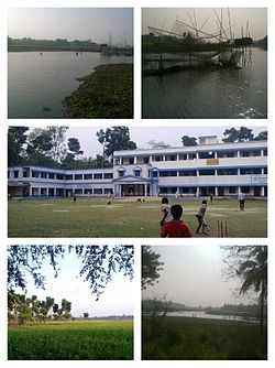
Kharua Rajapur is a village in Kalupur gram panchayat in Bangaon CD Block in Bangaon subdivision of North 24 Parganas district in the Indian state of West Bengal.
Kharua Rajapur | |
|---|---|
Village | |
 | |
| Nickname(s): Rajapur | |
 Kharua Rajapur Location in West Bengal, India  Kharua Rajapur Kharua Rajapur (India) | |
| Coordinates: 22.99479°N 88.753568°E | |
| Country | India |
| State | West Bengal |
| Division | Presidency division |
| District | North 24 Parganas district |
| Government Gram Panchayet | |
| • Panchayet Pradhan | Hema Biswas (TMC) |
| Area | |
| • Village | 2.33 km2 (0.90 sq mi) |
| • Rural | 233 ha (576 acres) |
| Dimensions | |
| • Length | 2.5 km (1.6 mi) |
| • Width | 1.3 km (0.8 mi) |
| Elevation | 9 m (30 ft) |
| Population (2011) | |
| • Village | 1,591 |
| • Density | 680/km2 (1,800/sq mi) |
| Time zone | UTC+5.30 (IST) |
| ISO 3166 code | IN-WB |
Geography
Kharua Rajapur is 15 kilometres (9.3 mi) from subdivision headquarters Bangaon and 52 kilometres (32 mi) from district headquarters Barasat. The nearest railway station is Chandpara railway station at Chandpara.[1]

Choita river flows past Kharua Rajapur.[2]
Demographics
In the 2011 census Kharua Rajapur had a population of 1591, of which 813 were males and 778 were females. Children age 0-6 number 151. The literacy rate is 89.93.[3]
Education

One higher secondary school and two primary schools operate in Kharua Rajapur:
- Kharua Rajapur High School (H.S)[4]
- G.R.F.P Primary School
- S.S.K.M Primary School
References
- "Kharua Rajapur pin code".
- "বিষমুক্ত জল দেবে কে,প্রশ্ন মানুষের". আনন্দবাজার প্রত্রিকা. Retrieved 8 April 2016.
- "Kharua Rajapur Population -North Twenty Four Parganas,West Bengal,India".
- "Kharua Rajapur High School-North Twenty Four Parganas,West Bengal".
Cities, towns, locations and neighbourhoods in North 24 Parganas district, Presidency division | ||||||||||||
|---|---|---|---|---|---|---|---|---|---|---|---|---|
| Municipal cities/ towns and Census towns |
|  | ||||||||||
| Locations other than cities and towns |
| |||||||||||
| Neighbourhoods of other cities and towns in the district | ||||||||||||
| Related topics |
| |||||||||||
Текст в блоке "Читать" взят с сайта "Википедия" и доступен по лицензии Creative Commons Attribution-ShareAlike; в отдельных случаях могут действовать дополнительные условия.
Другой контент может иметь иную лицензию. Перед использованием материалов сайта WikiSort.org внимательно изучите правила лицензирования конкретных элементов наполнения сайта.
Другой контент может иметь иную лицензию. Перед использованием материалов сайта WikiSort.org внимательно изучите правила лицензирования конкретных элементов наполнения сайта.
2019-2026
WikiSort.org - проект по пересортировке и дополнению контента Википедии
WikiSort.org - проект по пересортировке и дополнению контента Википедии