world.wikisort.org - Indien
Distrikt Shopian (Urdu شوپیاں ضلع), auch Shopiyan, ist ein Verwaltungsdistrikt im Kaschmirtal im indischen Unionsterritorium Jammu und Kashmir.
| Distrikt Shopian شوپیاں ضلع | |
| Staat: | |
| Unionsterritorium: | Jammu und Kashmir |
| Division: | Kaschmir |
| Verwaltungssitz: | Shopian |
| Koordinaten: | 33° 43′ N, 74° 50′ O |
| Fläche: | 312 km² |
| Einwohner (2011):[1] | 266.215 |
| Bevölkerungsdichte: | 853 Einwohner je km² |
| Religionen (2011):[1] | 1,2 % Hindus 98,5 % Muslime 0,4 % übrige und k. A. |
| Soziale Daten (Zensus 2011)[1] | |
| Alphabetisierungsrate: | 60,8 % (M: 70,3 %, F: 50,9 %) |
| Geschlechterverhältnis: | 1,052 (M:F) |
| Urbanisierungsgrad: | 6,1 % |
| Scheduled Castes: | 0,0 % |
| Scheduled Tribes: | 8,2 % |
| Website: | |
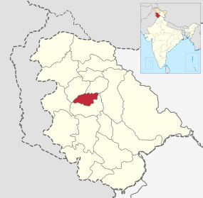 | |
Der Distrikt Shopian entstand 2007, als er aus dem damaligen Distrikt Pulwama herausgelöst wurde. Der Verwaltungssitz des Distrikts ist die Stadt Shopian.
Bevölkerung
Nach der Volkszählung von 2011 hatte der Distrikt 266.215 Einwohner. Damit lag er auf Rang 577 von 640 Distrikten in Indien. Die Bevölkerungsdichte betrug 853 Einwohner pro Quadratkilometer. Der Bevölkerungszuwachs von 2001 bis 2011 betrug 25,85 %. Die Geschlechterverteilung des Distrikts waren 951 Frauen auf 1000 Männer. Die Alphabetisierungsrate lag bei 60,76 %.[2]
Weblinks
Commons: Distrikt Shopian – Sammlung von Bildern, Videos und Audiodateien
Einzelnachweise
- 1. District Census 2011. Census of India, abgerufen im Jahr 2021 (englisch).
2. Population Enumeration Data (Final Population): A Series Including Primary Census Abstract Data (Final Population) > Primary Census Abstract Data Tables (India & States/UTs - District Level) (Excel Format). (XLS) Office of the Registrar General & Census Commissioner, India, archiviert vom Original am 23. April 2022; abgerufen im Jahr 2022 (englisch). - Volkszählungsdaten 2011 Shopian Distrikt, abgerufen am 1. August 2015.

Distrikte in Jammu und Kashmir
На других языках
- [de] Shopian (Distrikt)
[en] Shopian district
Shopian or Shupiyan (Urdu pronunciation: [ʃʊpɪjãː]), known as Shupyan[4] (Kashmiri pronunciation: [ʃupʲjan]) in Kashmiri, is a hill district with its administrative division in Shopian, located in the Indian union territory of Jammu and Kashmir,[5] since it is situated on the historical road commonly known as Mughal Road, most of its area is occupied by forests. Shopian district comes under the Pir Panjal Range which makes it very cold in winter.[6] After partition of India, it was a tehsil of Pulwama district. In March, 2007, the district status was granted by the Government of India.[7][8] The economy of the district depends on agriculture, particularly apple growing.[9] Shopian is 22 km (14 mi) from Aglar which connects it with Pulwama district and is one of the border towns of the district.[ru] Шопиан (округ)
Шопиан (кашм. शोपियां ज़िला (деванагари), شوپیاں ضلع (перс.); англ. Shopian) — округ в индийской союзной территории Джамму и Кашмир, в регионе Кашмир. Образован в 2007 году из части территории округа Пулвама. Административный центр — город Шопиан. Площадь округа — 307 км². По данным всеиндийской переписи 2001 года население округа составляло 246 041 человек.Текст в блоке "Читать" взят с сайта "Википедия" и доступен по лицензии Creative Commons Attribution-ShareAlike; в отдельных случаях могут действовать дополнительные условия.
Другой контент может иметь иную лицензию. Перед использованием материалов сайта WikiSort.org внимательно изучите правила лицензирования конкретных элементов наполнения сайта.
Другой контент может иметь иную лицензию. Перед использованием материалов сайта WikiSort.org внимательно изучите правила лицензирования конкретных элементов наполнения сайта.
2019-2026
WikiSort.org - проект по пересортировке и дополнению контента Википедии
WikiSort.org - проект по пересортировке и дополнению контента Википедии