world.wikisort.org - Indien
Der Distrikt Kathua (Urdu ضلع کٹھوعہ) ist ein Distrikt im indischen Unionsterritorium Jammu und Kashmir.
| Distrikt Kathua ضلع کٹھوعہ | |
| Staat: | |
| Unionsterritorium: | Jammu und Kashmir |
| Division: | Jammu |
| Verwaltungssitz: | Kathua |
| Koordinaten: | 32° 25′ N, 75° 32′ O |
| Fläche: | 2 502 km² |
| Einwohner (2011):[1] | 616.435 |
| Bevölkerungsdichte: | 246 Einwohner je km² |
| Religionen (2011):[1] | 87,6 % Hindus 10,4 % Muslime 1,5 % Sikhs 0,4 % übrige und k. A. |
| Soziale Daten (Zensus 2011)[1] | |
| Alphabetisierungsrate: | 73,1 % (M: 81,5 %, F: 63,7 %) |
| Geschlechterverhältnis: | 1,123 (M:F) |
| Urbanisierungsgrad: | 14,6 % |
| Scheduled Castes: | 22,9 % |
| Scheduled Tribes: | 8,6 % |
| Website: | |
 | |
Sitz der Distriktverwaltung ist die gleichnamige Stadt Kathua.

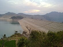
Der Distrikt liegt im äußersten Südosten von Jammu und Kashmir. Er erstreckt sich vom Pir Panjal über die Siwaliks bis ins Tiefland. Der Fluss Ravi verläuft entlang der östlichen Distriktgrenze und wird von der Ranjit-Sagar-Talsperre aufgestaut.
Der Distrikt hat eine Fläche von 2651 km² und 616.435 Einwohner (Zensus 2011).[2] 2001 lag die Einwohnerzahl noch bei 511.455.[2] Die Bevölkerungsdichte liegt bei 233 Einwohnern pro Quadratkilometer.
Der Distrikt ist in 5 Tehsils gegliedert: Bani, Bashohli, Billawar, Hiranagar und Kathua.
Weblinks
Commons: Distrikt Kathua – Sammlung von Bildern, Videos und Audiodateien
Einzelnachweise
- 1. District Census 2011. Census of India, abgerufen im Jahr 2021 (englisch).
2. Population Enumeration Data (Final Population): A Series Including Primary Census Abstract Data (Final Population) > Primary Census Abstract Data Tables (India & States/UTs - District Level) (Excel Format). (XLS) Office of the Registrar General & Census Commissioner, India, archiviert vom Original am 23. April 2022; abgerufen im Jahr 2022 (englisch). - census2011.co.in
На других языках
- [de] Kathua (Distrikt)
[en] Kathua district
Kathua district is one of 20 administrative districts that comprise the Indian union territory of Jammu and Kashmir. It is surrounded by Jammu to the northwest, the Doda and Udhampur districts to the north, the state of Himachal Pradesh to the east, Punjab to the south, and Pakistan's working boundary to the west. Its terrain is diverse, consisting of rich agricultural areas along the Punjab/Kashmir border, plains sweeping eastward to the foothills of the Himalaya, and the mountainous Pahari region in the east..[ru] Катхуа (округ)
Катхуа (англ. Kathua) — округ в индийской союзной территории Джамму и Кашмир, в регионе Джамму. Административный центр — город Катхуа. Площадь округа — 2651 км². По данным всеиндийской переписи 2001 года население округа составляло 550 084 человека.Текст в блоке "Читать" взят с сайта "Википедия" и доступен по лицензии Creative Commons Attribution-ShareAlike; в отдельных случаях могут действовать дополнительные условия.
Другой контент может иметь иную лицензию. Перед использованием материалов сайта WikiSort.org внимательно изучите правила лицензирования конкретных элементов наполнения сайта.
Другой контент может иметь иную лицензию. Перед использованием материалов сайта WikiSort.org внимательно изучите правила лицензирования конкретных элементов наполнения сайта.
2019-2025
WikiSort.org - проект по пересортировке и дополнению контента Википедии
WikiSort.org - проект по пересортировке и дополнению контента Википедии
