world.wikisort.org - Ungarn
Letenye (kroatisch Letinja, slowenisch Letina) ist eine ungarische Stadt im gleichnamigen Kreis im Komitat Zala.
| Letenye | |||||
| |||||
| Basisdaten | |||||
|---|---|---|---|---|---|
| Staat: | Ungarn | ||||
| Region: | Westtransdanubien | ||||
| Komitat: | Zala | ||||
| Kleingebiet bis 31.12.2012: | Letenye | ||||
| Kreis seit 1.1.2013: | Letenye | ||||
| Koordinaten: | 46° 26′ N, 16° 43′ O | ||||
| Fläche: | 41,72 km² | ||||
| Einwohner: | 4.119 (1. Jan. 2011) | ||||
| Bevölkerungsdichte: | 99 Einwohner je km² | ||||
| Telefonvorwahl: | (+36) 93 | ||||
| Postleitzahl: | 8868 | ||||
| KSH-kód: | 12122 | ||||
| Struktur und Verwaltung (Stand: 2020) | |||||
| Gemeindeart: | Stadt | ||||
| Bürgermeister: | Szilárd Farkas[1] (parteilos) | ||||
| Postanschrift: | Kossuth Lajos u. 10 8868 Letenye | ||||
| Website: | |||||
| (Quelle: A Magyar Köztársaság helységnévkönyve 2011. január 1. bei Központi statisztikai hivatal) | |||||


Geographische Lage
Letenye liegt etwa ein Kilometer vom linken Ufer der Mur entfernt, die hier die Grenze zu Kroatien bildet. Über die Autópálya M7 sind es etwa 230 km in die ungarische Hauptstadt Budapest. Über die Autocesta A4 sind es knapp 100 km in die kroatische Hauptstadt Zagreb.
Geschichte
Letenye wurde 1314 erstmals urkundlich erwähnt.
Sehenswürdigkeiten
- Schlosspark und Herrenhaus Szapáry
- mit von Imre Makovecz entworfener Holzbibliothek[2]
- 500 Jahre alte Ahornblättrige Platane (Platanus acerifolia), ⊙ im Park hinter dem Herrenhaus
- Teilnehmer am Wettbewerb „Europäischer Baum des Jahres“[3] 2011 als Vertreter Ungarns.
Städtepartnerschaften
 Conselice, Emilia-Romagna
 Prelog, Kroatien
 Prinzersdorf, Niederösterreich
Söhne und Töchter
- Mór Korach (1888–1975), ungarischer Chemiker
- Feró Nagy (* 1946), ungarischer Rocksänger
Einzelnachweise
- Helyi önkormányzati választások 2019 - Letenye (Zala megye). Nemzeti Választási Iroda, abgerufen am 11. Juli 2020 (ungarisch).
- Letenye - Légrád: Letenye and Međimurje county
- ETOY 2011: Plane in Letenye
Weblinks
Commons: Letenye – Sammlung von Bildern, Videos und Audiodateien
- Letenye auf 24cities.eu, Kompetenzzentrum Steirisches Thermenland-Oststeiermark
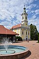 Dreifaltigkeitskirche im Zentrum
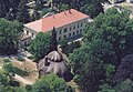 Luftaufnahme vom Schloss Szapáry (2007)
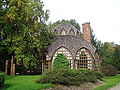 Stadtbibliothek Letenye
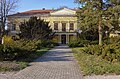 Herrenhaus Szapáry-Andrássy
 500 jährige Platane in Letenye
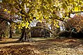 Teilnehmer beim Wettbewerb "Europäischer Baum des Jahres" 2011


На других языках
- [de] Letenye
[ru] Летенье
Летенье (венг. Letenye) — город в западной Венгрии, на юго-западе медье Зала.Текст в блоке "Читать" взят с сайта "Википедия" и доступен по лицензии Creative Commons Attribution-ShareAlike; в отдельных случаях могут действовать дополнительные условия.
Другой контент может иметь иную лицензию. Перед использованием материалов сайта WikiSort.org внимательно изучите правила лицензирования конкретных элементов наполнения сайта.
Другой контент может иметь иную лицензию. Перед использованием материалов сайта WikiSort.org внимательно изучите правила лицензирования конкретных элементов наполнения сайта.
2019-2026
WikiSort.org - проект по пересортировке и дополнению контента Википедии
WikiSort.org - проект по пересортировке и дополнению контента Википедии