world.wikisort.org - Germany
The Weißeritzkreis is a former district (Kreis) in the south of Saxony, Germany. Neighboring districts were (from west clockwise) Freiberg, Meißen, the district-free city Dresden, Sächsische Schweiz, and to the south it bordered the Czech Republic.
Weißeritzkreis | |
|---|---|
District | |
 | |
| Country | Germany |
| State | Saxony |
| Adm. region | Dresden |
| Disbanded | 2008-08-01 |
| Capital | Dippoldiswalde |
| Area | |
| • Total | 765 km2 (295 sq mi) |
| Population (2001) | |
| • Total | 124,091 |
| • Density | 160/km2 (420/sq mi) |
| Time zone | UTC+01:00 (CET) |
| • Summer (DST) | UTC+02:00 (CEST) |
| Vehicle registration | DW |
| Website | www |
History
The district was created in 1994 when the two districts Dippoldiswalde and Freital were merged. In August 2008, as a part of the district reform in Saxony, the districts of Sächsische Schweiz and Weißeritzkreis were merged into the new district Sächsische Schweiz-Osterzgebirge.
Geography
The district is located in the Ore Mountains, the central part is the Tharandt Forest. The district got its name after the two rivers Wild Weißeritz and Red Weißeritz, who merge near Freital into the Weißeritz river, and then mouths into the Elbe in Dresden. The highest elevation is the Kahleberg at 905 metres (2,969 ft).
During the flooding in August 2002 the Weißeritz river had to drain many times the normal amount of water, and did destroy a lot of buildings in the river valley - houses, streets and bridges.
Partnerships
- Rottweil
- Berchtesgadener Land
- Göttingen
- Zollernalbkreis
Coat of arms
 |
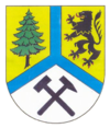
The blue lines symbolize the Weißeritz river, and its splitting into the Wild Weißeritz and the Red Weißeritz rivers. The mining symbol in the bottom represents the old ore and coal mining tradition in the Ore Mountains. The tree stands for the rich forests in the district, and the lion to the right is the symbol of Meißen, as the area historically belonged to the margraviate of Meißen. |
Towns and municipalities
| Towns | Municipalities |
|---|---|
External links
- Official website (German)
- Website about the 2002 Flooding (German)
На других языках
[de] Weißeritzkreis
Der Weißeritzkreis war bis zur Kreisreform 2008 ein Landkreis im Freistaat Sachsen. Seit 1. August 2008 gehört das Gebiet des ehemaligen Landkreises zum Landkreis Sächsische Schweiz-Osterzgebirge. Angrenzende Landkreise waren Freiberg, Meißen, Sächsische Schweiz sowie die kreisfreie Stadt Dresden. Im Süden grenzte der Weißeritzkreis an die Tschechische Republik (Okres Teplice).- [en] Weißeritzkreis
[it] Circondario di Weißeritz
Il circondario di Weißeritz (in tedesco Weißeritzkreis) era una suddivisione amministrativa del Land Sassonia con una popolazione di 121.239 abitanti, che aveva come capoluogo Dippoldiswalde.[ru] Вайсериц (район)
Ва́йсериц (нем. Weißeritz) — бывший район в Германии.Другой контент может иметь иную лицензию. Перед использованием материалов сайта WikiSort.org внимательно изучите правила лицензирования конкретных элементов наполнения сайта.
WikiSort.org - проект по пересортировке и дополнению контента Википедии
