world.wikisort.org - Germany
Sparneck is a municipality in Upper Franconia in the district of Hof in Bavaria in Germany.
Sparneck | |
|---|---|
Municipality | |
 Church of Saint Vitus | |
 Coat of arms | |
Location of Sparneck within Hof district 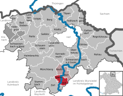 | |
 Sparneck  Sparneck | |
| Coordinates: 50°10′N 11°49′E | |
| Country | Germany |
| State | Bavaria |
| Admin. region | Oberfranken |
| District | Hof |
| Municipal assoc. | Sparneck |
| Subdivisions | 9 Ortsteile |
| Government | |
| • Mayor (2020–26) | Daniel Schreiner[1] |
| Area | |
| • Total | 16.36 km2 (6.32 sq mi) |
| Elevation | 560 m (1,840 ft) |
| Population (2020-12-31)[2] | |
| • Total | 1,564 |
| • Density | 96/km2 (250/sq mi) |
| Time zone | UTC+01:00 (CET) |
| • Summer (DST) | UTC+02:00 (CEST) |
| Postal codes | 95234 |
| Dialling codes | 09251 |
| Vehicle registration | HO |
| Website | www.sparneck.de |
Location
The market town of Sparneck lies at an average height of 560 m above sea level (NN) in the Pfarrbach valley, which forms the larger part of the area. The Saxon Saale river flows through this valley in a northerly direction. Towards the east the 877 metre high Waldstein ridge rises, the source of the Saale is on its slopes. It forms the natural boundary with the neighbouring district of Wunsiedel.
History
Sparneck is first mentioned 1223 with a person from Sparneck family.
References
- Liste der ersten Bürgermeister/Oberbürgermeister in kreisangehörigen Gemeinden, Bayerisches Landesamt für Statistik, 15 July 2021.
- "Tabellenblatt "Daten 2", Statistischer Bericht A1200C 202041 Einwohnerzahlen der Gemeinden, Kreise und Regierungsbezirke". Bayerisches Landesamt für Statistik (in German). June 2021.
Wikimedia Commons has media related to Sparneck.
Towns and municipalities in Hof (district) | ||
|---|---|---|
|  | |
This Hof district location article is a stub. You can help Wikipedia by expanding it. |
На других языках
- [en] Sparneck
[ru] Шпарнекк
Шпарнекк (нем. Sparneck) — община в Германии, в Республике Бавария[1].Текст в блоке "Читать" взят с сайта "Википедия" и доступен по лицензии Creative Commons Attribution-ShareAlike; в отдельных случаях могут действовать дополнительные условия.
Другой контент может иметь иную лицензию. Перед использованием материалов сайта WikiSort.org внимательно изучите правила лицензирования конкретных элементов наполнения сайта.
Другой контент может иметь иную лицензию. Перед использованием материалов сайта WikiSort.org внимательно изучите правила лицензирования конкретных элементов наполнения сайта.
2019-2026
WikiSort.org - проект по пересортировке и дополнению контента Википедии
WikiSort.org - проект по пересортировке и дополнению контента Википедии