world.wikisort.org - Germany
Roetgen (German pronunciation: [ˈʁøːtçən]]) is a municipality in the district of Aachen, in North Rhine-Westphalia, Germany.
Roetgen | |
|---|---|
Municipality | |
 Coat of arms | |
Location of Roetgen within Aachen district 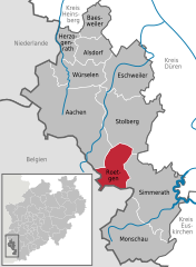 | |
 Roetgen  Roetgen | |
| Coordinates: 50°39′N 6°12′E | |
| Country | Germany |
| State | North Rhine-Westphalia |
| Admin. region | Köln |
| District | Aachen |
| Subdivisions | 3 |
| Government | |
| • Mayor (2020–25) | Jorma Klauss[1] (SPD) |
| Area | |
| • Total | 39.033 km2 (15.071 sq mi) |
| Elevation | 386 m (1,266 ft) |
| Population (2020-12-31)[2] | |
| • Total | 8,650 |
| • Density | 220/km2 (570/sq mi) |
| Time zone | UTC+01:00 (CET) |
| • Summer (DST) | UTC+02:00 (CEST) |
| Postal codes | 52159 |
| Dialling codes | 02471 |
| Vehicle registration | AC, MON |
| Website | www.roetgen.de |
Geography
Roetgen is located approximately 16 km (10 mi) south-east of Aachen, near the border with Belgium. It is in the north of the High Fens-Eifel Nature Park on the Weser stream which rises a few kilometres to the south. Between Roetgen and Rott is the Dreilägerbach Reservoir, which is fed by the Dreilägerbach stream and the artificially Schleebachgraben and Hasselbachgraben ditches. The attached waterworks supplies large parts of Aachen and the Dutch town of Kerkrade with drinking water.
The parish of Roetgen includes the villages of Roetgen, Rott and Mulartshütte, which is the oldest part of Roetgen.
To the northwest is the borough of Aachen with its quarters of Kornelimünster and Walheim, to the northeast is the town of Stolberg with its quarters of Venwegen and Zweifall, to the southeast is the Simmerath parish of Lammersdorf. To the west, on the far side of the German-Belgian border lies the town of Eupen and the municipalities of Raeren, whose parish of Petergensfeld borders immediately on Roetgen north of Charliers Mill.
Roetgen is attractive for commuters as it is already part of the Eifel and yet is still close in proximity to Aachen.
History
In World War II, Roetgen was the first German town to fall under American control. American forces arrived in the town on 12 September 1944 at 14.30.[3]
The city was the location of the court martial of US Army Private Eddie Slovik in November 1944, notable because of all US military personnel in World War II, only Slovik was ever executed for desertion.
On March 13, 2019, Roetgen was hit by a low-end F3 tornado. The tornado caused moderate to severe damage to buildings and trees. Vehicles were also overturned and flipped. 5 people were injured by the tornado.[4][5][6][7][8]
Division of the municipality
Roetgen consists of three districts:
- Roetgen
- Rott
- Mulartshütte
Mulartshütte is the oldest settlement of the three.
Sights
- St. Mary's Chapel (Marienkapelle, 1636–1660) is the surviving part of the first Roman Catholic parish church in Roetgen. It was partially demolished when the Neogothic St. Hubert's Church (1854–1856) was built. It was consecrated to Saint Hubertus of Liège, the Virgin Mary and John the Baptist.
- In Roetgen's town hall there is a sculpture of a weaver by Hermann Pier (1925–1985); outside on the forecourt is a replica. It has historical as well as artistic value, because this craft was an important part of Roetgen's economic history.
- Charliers Mill (substructure of rubble stone, 1768) is an old water mill (today a domestic residence) on the Weser stream. In the countryside behind the mill, with its pastures, rows of beech rows and ponds runs Stage 1 of the Eifelsteig hiking trail.
Gallery
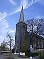 St. Hubert's Roman Catholic Church
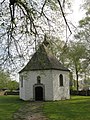 St. Mary's Chapel
 The Protestant church


References
- Wahlergebnisse in NRW Kommunalwahlen 2020, Land Nordrhein-Westfalen, accessed 19 June 2021.
- "Bevölkerung der Gemeinden Nordrhein-Westfalens am 31. Dezember 2020" (in German). Landesbetrieb Information und Technik NRW. Retrieved 21 June 2021.
- New York Times, 14 Sep 1944.
- "Roetgen (Nordrhein-Westfalen), 13.03.2019".
- "13.3.2019 der Roetgener Tornado: Dokumentation vor Ort, Analyse der Zugbahn und Radaranalyse | eifelmomente.de".
- "Tornado in Roetgen: Zerstörte Häuser, Chaos in den Straßen: Windhose in der Eifel". 14 March 2019.
- "Häuser abgedeckt, Laternen umgeknickt: Tornado zieht Schneise der Verwüstung durch Roetgen". 14 March 2019.
- "Langfristige Folgen: Tornadoschäden im Roetgener Wald "schlimm genug"". 26 May 2019.
External links
- Official website
 (in German)
Towns and municipalities in Aachen district | ||
|---|---|---|
 | ||
Authority control | |
|---|---|
| General | |
| National libraries | |
| Other |
|
На других языках
[de] Roetgen
Roetgen ([.mw-parser-output .IPA a{text-decoration:none}ˈʁøːtçən], Röhtchen) ist eine Gemeinde in Nordrhein-Westfalen an der Grenze zu Belgien. Sie gehört zur Städteregion Aachen. Durch die Nähe zu Aachen wurde die Gemeinde vor allem für Pendler interessant, es existieren daher verschiedene Neubaugebiete aus den 1970er, 1980er und 1990er Jahren sowie ein Gewerbegebiet aus den 1990er Jahren. Seit dem 27. November 2012 trägt die Gemeinde offiziell den Titel Tor zur Eifel.[2]- [en] Roetgen
[ru] Рётген
Рётген (нем. Roetgen) — коммуна в Германии, в земле Северный Рейн-Вестфалия.Другой контент может иметь иную лицензию. Перед использованием материалов сайта WikiSort.org внимательно изучите правила лицензирования конкретных элементов наполнения сайта.
WikiSort.org - проект по пересортировке и дополнению контента Википедии