world.wikisort.org - Germany
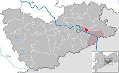
Rathmannsdorf is a township in the Saxon district of Sächsische Schweiz-Osterzgebirge. Rathmannsdorf is 2 km (1 mi) down the Elbe from Bad Schandau.
Rathmannsdorf | |
|---|---|
Municipality | |
 Coat of arms | |
Location of Rathmannsdorf within Sächsische Schweiz-Osterzgebirge district  | |
 Rathmannsdorf  Rathmannsdorf | |
| Coordinates: 50°56′N 14°08′E | |
| Country | Germany |
| State | Saxony |
| District | Sächsische Schweiz-Osterzgebirge |
| Municipal assoc. | Bad Schandau |
| Subdivisions | 5 |
| Government | |
| • Mayor (2022–29) | Uwe Thiele[1] (CDU) |
| Area | |
| • Total | 4.37 km2 (1.69 sq mi) |
| Elevation | 225 m (738 ft) |
| Population (2021-12-31)[2] | |
| • Total | 893 |
| • Density | 200/km2 (530/sq mi) |
| Time zone | UTC+01:00 (CET) |
| • Summer (DST) | UTC+02:00 (CEST) |
| Postal codes | 01814 |
| Dialling codes | 035022 |
| Vehicle registration | PIR |
| Website | www.rathmannsdorf.de |
Geography
The township's highest point is a plateau near Bad Schandau 200 meters above sea level, with the lowest point 120 meters above sea level along the Elbe. The township consists of the districts Wendischfähre, Höhe, Zauke, Plan and Gluto.[3]
History
Rathmannsdorf was first mentioned in a document in 1443. Rathmannsdorf along with Bad Schandau, Porschdorf, and Reinhardtsdorf-Schöna form a Verwaltungsgemeinschaft. The town is also a stop on the Sebnitztalbahn part of the Sächsische Semmering-Bahn, a local railroad.
References
- Gewählte Bürgermeisterinnen und Bürgermeister im Freistaat Sachsen, Stand: 17. Juli 2022, Statistisches Landesamt des Freistaates Sachsen.
- "Bevölkerung des Freistaates Sachsen nach Gemeinden am 31. Dezember 2021" (XLS) (in German). Statistisches Landesamt des Freistaates Sachsen. 2022.
- "Community information". Gemeinde Rathmannsdorf in the center of the Elbsandsteingebirge. Gemeinde Rathmannsdorf. Retrieved 2 February 2019.
На других языках
[de] Rathmannsdorf
Rathmannsdorf ist eine Gemeinde in Sachsen in der Nähe der Städte Hohnstein und Pirna. Die Gemeinde liegt etwa zwei Kilometer elbabwärts von Bad Schandau im rechtselbischen Naturraum des Elbsandsteingebirges und grenzt an den Nationalpark Sächsische Schweiz. Rathmannsdorf bildet zusammen mit Bad Schandau und Reinhardtsdorf-Schöna die Verwaltungsgemeinschaft Bad Schandau.- [en] Rathmannsdorf
[fr] Rathmannsdorf
Rathmannsdorf est une commune de Saxe (Allemagne), située dans l'arrondissement de Suisse-Saxonne-Monts-Métallifères-de-l'Est, dans le district de Dresde et à deux kilomètres de Bad Schandau.[ru] Ратмансдорф (Саксония)
Ратмансдорф (нем. Rathmannsdorf) — коммуна в Германии, в земле Саксония. Подчиняется земельной дирекции Дрезден. Входит в состав района Саксонская Швейцария. Подчиняется управлению Бад Шандау. Население составляет 1011 человек (на 31 декабря 2010 года). Занимает площадь 4,37 км². Официальный код — 14 2 87 320.Текст в блоке "Читать" взят с сайта "Википедия" и доступен по лицензии Creative Commons Attribution-ShareAlike; в отдельных случаях могут действовать дополнительные условия.
Другой контент может иметь иную лицензию. Перед использованием материалов сайта WikiSort.org внимательно изучите правила лицензирования конкретных элементов наполнения сайта.
Другой контент может иметь иную лицензию. Перед использованием материалов сайта WikiSort.org внимательно изучите правила лицензирования конкретных элементов наполнения сайта.
2019-2025
WikiSort.org - проект по пересортировке и дополнению контента Википедии
WikiSort.org - проект по пересортировке и дополнению контента Википедии
