world.wikisort.org - Germany
Lauta (Sorbian: Łuty) is a town in the district of Bautzen, in Saxony, Germany. It is situated 10 km west of Hoyerswerda, and 10 km southeast of Senftenberg.
Lauta
Łuty | |
|---|---|
Town | |
|
Coat of arms | |
Location of Lauta within Bautzen district  | |
 Lauta  Lauta | |
| Coordinates: 51°26′53″N 14°5′59″E | |
| Country | Germany |
| State | Saxony |
| District | Bautzen |
| Subdivisions | 3 |
| Government | |
| • Mayor (2022–29) | Frank Lehmann[1] |
| Area | |
| • Total | 41.87 km2 (16.17 sq mi) |
| Elevation | 123 m (404 ft) |
| Population (2020-12-31)[2] | |
| • Total | 8,211 |
| • Density | 200/km2 (510/sq mi) |
| Time zone | UTC+01:00 (CET) |
| • Summer (DST) | UTC+02:00 (CEST) |
| Postal codes | 02991 |
| Dialling codes | 035722 |
| Vehicle registration | BZ, BIW, HY, KM |
| Website | www.lauta.de |
History
From 1815 to 1825, within the Prussian Province of Brandenburg, Lauta was part of Landkreis Calau. From 1825 to 1919 it was part of the Province of Silesia, from 1919 to 1938 of the Province of Lower Silesia, again from 1938 to 1941 of the Province of Silesia and again from 1941 to 1945 of the Province of Lower Silesia. From 1945 to 1952, it was part of Saxony. From 1952 to 1990, within the East German Bezirk Cottbus, it was part of Kreis Hoyerswerda. With German reunification in 1990, it became part of Saxony.
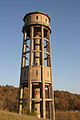 Watertower
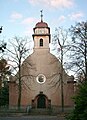 Catholic church
 Housing complex
 Monument in Laubusch, district of Lauta


Personality
Personalities who worked in Lauta
- Albert Zimmermann, resistance fighter, executed on 27 November 1944
Personalities who lived temporarily in Lauta
- Peter Mädler, (1943–1963), death at the Berlin Wall (1963), 1958–1961 electrician apprentice in the power plant Lauta.
- Joachim Hansen, (1930–2007), actor
References
- Gewählte Bürgermeisterinnen und Bürgermeister im Freistaat Sachsen, Stand: 17. Juli 2022, Statistisches Landesamt des Freistaates Sachsen.
- "Bevölkerung des Freistaates Sachsen nach Gemeinden am 31. Dezember 2020". Statistisches Landesamt des Freistaates Sachsen (in German). June 2021.

This Bautzen location article is a stub. You can help Wikipedia by expanding it. |
На других языках
[de] Lauta
Lauta (sorbisch Łuty) ist eine Kleinstadt im Norden des sächsischen Landkreises Bautzen.- [en] Lauta
[es] Lauta
Lauta (Łuty, en sorbio) es una pequeña ciudad en el norte del distrito de Bautzen, en el estado alemán de Sajonia.[ru] Лаута
Лау́та или Луты (нем. Lauta, в.-луж. Łuty) — город в Германии, в земле Саксония. Подчинён административному округу Дрезден. Входит в состав района Баутцен. Население составляет 9 341 человек (на 31 декабря 2010). Занимает площадь 41,87 км². Официальный код — 14 2 92 290.Другой контент может иметь иную лицензию. Перед использованием материалов сайта WikiSort.org внимательно изучите правила лицензирования конкретных элементов наполнения сайта.
WikiSort.org - проект по пересортировке и дополнению контента Википедии