world.wikisort.org - Germany
Ingelheim (German: [ˈɪŋəlhaɪ̯m] (![]() listen)), officially Ingelheim am Rhein (English: Ingelheim upon Rhine), is a town in the Mainz-Bingen district in the Rhineland-Palatinate state of Germany. The town sprawls along the Rhine's west bank. It has been Mainz-Bingen's district seat since 1996.
listen)), officially Ingelheim am Rhein (English: Ingelheim upon Rhine), is a town in the Mainz-Bingen district in the Rhineland-Palatinate state of Germany. The town sprawls along the Rhine's west bank. It has been Mainz-Bingen's district seat since 1996.
Ingelheim am Rhein | |
|---|---|
Town | |
 | |
 Flag  Coat of arms | |
Location of Ingelheim am Rhein within Mainz-Bingen district  | |
 Ingelheim am Rhein  Ingelheim am Rhein | |
| Coordinates: 49°58′29″N 8°3′23″E | |
| Country | Germany |
| State | Rhineland-Palatinate |
| District | Mainz-Bingen |
| Government | |
| • Lord mayor (2019–27) | Ralf Claus[1] (SPD) |
| Area | |
| • Total | 73.33 km2 (28.31 sq mi) |
| Highest elevation | 247 m (810 ft) |
| Lowest elevation | 80 m (260 ft) |
| Population (2020-12-31)[2] | |
| • Total | 35,161 |
| • Density | 480/km2 (1,200/sq mi) |
| Time zone | UTC+01:00 (CET) |
| • Summer (DST) | UTC+02:00 (CEST) |
| Postal codes | 55218 |
| Dialling codes | 06132 06130-Großwinternheim 06725-Sporkenheim |
| Vehicle registration | MZ, BIN |
| Website | www.ingelheim.de |

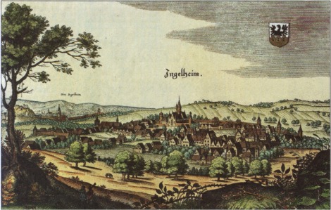
From the later half of the 8th century, the Ingelheim Imperial Palace, which served emperors and kings as a lodging and a ruling seat until the 11th century, was to be found here.
Etymology
The typically Rhenish-Hessian placename ending —heim might well go back to Frankish times, that is to say, likely as far back as the 5th or 6th century. Settlements or estates then took their lords’ names and were given this suffix, which means "home" in German. The name is recorded in later documents as Ingilinhaim, Ingilinheim (782), Ingilenhaim, Engelheim, Hengilonheim, Engilonheim (822), Engilinheim (826), Hingilinheim (855), Ingilunheim (874), Ingulinheim (889), Ingelesheim (891), Ingelenheim (940), Anglia sedes (1051), Ingilheim and Ingelnheim (1286), among other forms.
Since 1269, a distinction has been made between Nieder-Ingelheim and Ober-Ingelheim (Lower and Upper Ingelheim).

Geography
Location
Ingelheim am Rhein lies in the north of Rhein Hessen on the so-called Rhein Knee, west of the state capital, Mainz. The Rhein forms the town's northern limit. Southwards, the town stretches into the valley of the river Selz, which empties into the Rhein in the constituent community of Frei-Weinheim or Ingelheim-Nord ("North").
The constituent communities of Ingelheim-Mitte and Ingelheim-Süd ("Middle" and "South") are nestled against the corner of the so-called Mainzer Berg ("Mainz Mountain").
The municipal area's lowest point is the harbour on the Rhein at 80.8 m above sea level. The two highest points are the Mainzer Berg at 247.8 m above sea level and the Westerberg at 247.5 m above sea level.
An obelisk on the south side of the village in direction Wackernheim, marks the road begun by Charlemagne, and completed by Napoleon. From this point a fine prospect of the entire Rheingau could be obtained.[3]
Municipal area’s extent
The municipal area's north-south extent is 7.9 km, while the east-west extent is 5 km.
Neighbouring municipalities
Clockwise from the north, these are Geisenheim, Oestrich-Winkel on the Rhine's right bank, and on the left bank Budenheim, Finthen, the Verbandsgemeinde of Nieder-Olm, Schwabenheim, Gau-Algesheim (both belonging to the Verbandsgemeinde of Gau-Algesheim) and Bingen am Rhein. Since 1 July 2019 Wackernheim and Heidesheim are incorporated into the city of Ingelheim.[4]
Constituent communities
Ingelheim is currently divided into six Stadtteile: Ingelheim-Mitte, Ingelheim-Nord, Ingelheim-Süd, Sporkenheim, Groß-Winternheim and Ingelheim-West. Before Ingelheim became a town in 1939, the first three centres bore the names Nieder-Ingelheim, Frei-Weinheim and Ober-Ingelheim. Official changes notwithstanding, the old names are still quite often used.
Climate
The town lies in the temperate zone. The average yearly temperature in Ingelheim is 9.8 °C. The warmest months are July and August with average temperatures of 18.0 and 18.5 °C respectively, and the coldest month is January at 1.0 °C on average. The most precipitation falls in June and August with an average of 64 mm, and the least in March with an average of 31 mm. Like all Rhenish Hesse, Ingelheim, too, is sheltered from the weather by the Hunsrück, the Taunus, the Odenwald and the Donnersberg, thereby limiting the yearly precipitation to only 560 mm.
| Month | Jan | Feb | Mar | Apr | May | Jun | Jul | Aug | Sep | Oct | Nov | Dec | Year |
|---|---|---|---|---|---|---|---|---|---|---|---|---|---|
| Temperature (°C) | 1.0 | 2.0 | 4.5 | 9.5 | 14 | 17 | 18 | 18 | 14.5 | 10.5 | 5 | 2 | 9.7 |
| Precipitation (mm) | 40 | 35 | 31 | 36 | 52 | 64 | 59 | 64 | 45 | 40 | 51 | 43 | 560 |
| Source: Deutscher Wetterdienst[5] | |||||||||||||
History
The Ingelheim area was already settled in prehistoric times. The place first earned itself particular importance, though, only under Charlemagne and his successors. Charlemagne had built the Ingelheim Imperial Palace (Ingelheimer Kaiserpfalz) here, where synods and Imperial diets were held in the time that followed. His son and successor, Emperor Louis the Pious, died on 20 June 840 in Ingelheim.
In the High and Late Middle Ages, the Palatinate's, and thereby also Ingelheim's, importance shrank.
For German justice history, the Ingelheimer Oberhof ("Ingelheim Upper Court") is of particular importance, as a unique collection of judgments from the 15th and 16th centuries that it handed down has been preserved.
Late 19th century Ingelheim was the residence of the Dutch writer Multatuli (Eduard Douwes Dekker).
In 1939, the formerly self-administering municipalities of Nieder-Ingelheim, Ober-Ingelheim and Frei-Weinheim were merged into the Town of Ingelheim am Rhein.

From the Second World War, Ingelheim emerged as the only unscathed town between Mainz and Koblenz. Today, Ingelheim is a middle centre in Rhineland-Palatinate, a Great District-Bound Town (Große kreisangehörige Stadt – a status deriving from the Rhineland-Palatinate Municipal Order) and the seat of district administration for Mainz-Bingen.
Furthermore, Ingelheim harbours the business Boehringer Ingelheim which is active worldwide.
Population data
Religion
In 2004, 36% of Ingelheim's inhabitants belonged to the Lutheran faith, and 34% were Catholic, while 24% were without any religious faith; from 2% of the population, no data were forthcoming.
The six Catholic parishes belong, within the Roman Catholic Diocese of Mainz to the Deanery of Bingen.
The five Protestant parishes of the EKHN belong to the Provostship (Propstei) of Mainz, and within this to the Deanery of Ingelheim.
Besides these, the Baptists, Religious humanists and Muslims each have small communities in Ingelheim, as do the Jehovah's Witnesses and Buddhists.

Until 1942 there was a Jewish community, whose beginnings went back to the 16th century. About 1850, roughly 200 Jewish inhabitants lived in Ober-Ingelheim, and by 1933 there were still 134 all together in Oberingelheim and Niederingelheim. In 1840 and 1841, a synagogue that was important to architectural history was built. It was dedicated on 27 August 1841 and destroyed on 9 November 1938 – Kristallnacht. Many Jewish inhabitants lost their lives after being deported to the death camps during the time of the Third Reich.
Amalgamations
On 22 April 1972 the municipality of Groß-Winternheim was amalgamated. The former municipalities Heidesheim am Rhein and Wackernheim were merged into Ingelheim am Rhein on 1 July 2019.
Population development
Before 1939
| Year | Nieder-Ingelheim | Ober-Ingelheim | Frei-Weinheim | total |
|---|---|---|---|---|
| 1815 | 1,360 | 1,738 | 192 | 3,290 |
| 1871 | 5,760 | |||
| 1885 | 2,729 | 3,160 | 701 | 6,590 |
| 1900 | 3,435 | 3,402 | 838 | 7,675 |
| 1905 | 8,098 | |||
| 1910 | 3,852 | 3,479 | 882 | 8,213 |
| 1933 | 5,157 | 4,116 | 1,183 | 10,456 |
| 1939 | 5,526 | 4,309 | 1,200 | 11,035 |


Beginning in 1939
|
| ||||||||||||||||||||||||||||||||||||||||||||||||||||


Politics
Town council
The municipal election held in 2004 yielded the following results:
| Party | % | Seats |
|---|---|---|
| Christian Democratic Union of Germany | 37.53% (-4.24%) | 13 |
| Social Democratic Party of Germany | 29.64% (-5.90%) | 11 |
| Grünen | 10.41% (+2.52%) | 4 |
| Liste Klose | 10.19% (+10.19%) | 4 |
| Freie Wähler | 7.30% (-2.33%) | 2 |
| Free Democratic Party | 4.93% (-0.24%) | 2 |
Mayor

In the last mayoral elections, held on 26 May 2019, Ralf Claus, mayor of Ingelheim since 2012, was reelected as mayor:
| Candidate | Party | % |
|---|---|---|
| Breyer, Eveline | CDU | 44.4% |
| Claus, Ralf | SPD | 55.6% |

Results of council elections since 1946
- 1946
- CDU: 42.2%
- SPD: 26%
- KPD: 9.2%
- Liste Gemünden/Gaul: 22.6%
- Eligible voters: 6,899
- Voter turnout: 88.6%
- 1948
- CDU: 35.1%
- SPD: 33.1%
- DP: 25.3%
- KP: 6.5%
- 9 November 1952
- Freie Bürgerliste Rausch: 40.1%, 2,882 votes — 11 seats
- SPD: 23.04%, 1,656 votes — 6 seats
- CDU: 22.43%, 1,612 votes — 6 seats
- FDP: 10.21%, 734 votes — 2 seats
- KPD: 4.2%, 303 votes
- Eligible voters: 9,488
- Voter turnout: 77.76%, 7378 votes, 7,187 valid votes
- 1956
- SPD: 36.79%, 2,611 votes — 9 seats
- CDU: 27.06%, 1,920 votes — 7 seats
- Wählergruppe Bambach: 24.45%, 1,735 votes — 6 seats
- FDP: 11.7%, 830 votes — 3 seats
- Eligible voters: 9,979
- Voter turnout: 72.62%, 7,247 votes, 7,096 valid votes
- 23 October 1960
- SPD: 42.61%, 3,114 votes — 11 seats
- CDU: 36.65%, 2,679 votes — 10 seats
- FDP: 16.92%, 1,237 votes — 2 seats
- Wählergruppe Kaufmann: 3.82%, 279 votes
- Eligible voters: 10,695
- Voter turnout: 70.14%, 7,502 votes, 7,309 valid votes
- 25 October 1964
- SPD: 51.7% — 13 seats (absolute majority)
- CDU: 34.7%, 2,800 votes — 9 seats
- FDP: 13.6%, 1,098 votes — 3 seats
- Eligible voters: 11,369 (50a CDU) 11,312 (40a Ing)
- Voter turnout: 72.77%, 8,231 votes (50a CDU) 8,232 (40a Ing)
- 8 June 1969
- CDU: 37.15%, 3,397 votes — 12 seats
- SPD: 34.45%, 3,150 votes — 11 seats
- FDP: 10.45%, 956 votes — 3 seats
- Freie Wählergruppe Kaege: 17.95%, 1,641 votes — 5 seats
- Eligible voters: 12,295
- Voter turnout: 75.51%, 9,309 votes, 9,144 valid votes
- 23 April 1972
- SPD: 41.99%, 4,263 votes — 14 seats (according to 40a 4,264)
- CDU: 38.92%, 3,952 votes — 12 seats
- FDP: 8.79%, 892 votes — 2 seats
- Wählergruppe Kaege: 10.28%, 1,044 votes — 3 seats
- Eligible voters: 13,992
- Voter turnout: 73.46%, 10,280 votes, 10,153 valid votes
- 17 March 1974
- CDU: 46.6%, 5,092 votes — 17 seats (40a: 46.40%)
- SPD: 34.34%, 3,769 votes — 12 seats
- FDP: 10.26%, 1,126 votes — 3 seats
- FWG: 8.98%, 986 votes — 3 seats
- Eligible voters: 14,027
- Voter turnout: 79.17%, 11,106 votes, 10,973 valid votes
- 10/11 June 1979
- SPD: 42.12%, 4,322 votes — 14 seats
- CDU: 41.52%, 4,261 votes — 13 seats
- FDP: 8.21%, 842 votes — 2 seats
- FWG: 8.15%, 837 votes — 2 seats
- Eligible voters: 14,238
- Voter turnout: 73.54%, 10,470 votes, 10,262 valid votes
- 17 June 1984
- CDU: 40.7%, 4,576 votes — 15 seats
- SPD: 44.1%, 4,966 votes — 16 seats
- FDP: 7.8% — 2 seats
- FWG: 10.6% — 2 seats
- DKP: 1% — 112 votes
- Eligible voters: 15,408
- Voter turnout: 74.9%, 11,252 valid votes
- 18 June 1989
- SPD: 41.0% — 15 seats
- CDU: 31.2% — 11 seats
- FWG: 10.6% — 4 seats
- FDP: 7.75% — 3 seats
- Grüne: 7.38% — 2 seats
- 12 June 1994
- SPD: 36.6% — 13 seats
- CDU: 31.0% — 11 seats
- FWG: 6 seats
- Grüne: 4 seats
- FDP: 2 seats
- Voter turnout: 70%, 11,781 votes
Mayors before 1939
- Nieder-Ingelheim
- Weitzel about 1881
- Leonard Muntermann (DDP, 1912 - 7 April 1932)
- Ober-Ingelheim
- Dr. Georg Rückert (February 1932 - April 1933)
- Gaul (1933-)
(Chief) Mayors since 1939
Mayors (Bürgermeister) from 1946, Chief Mayors (Oberbürgermeister) from 1972:
- 1939-1945: Franz Bambach (NSDAP)
- 15 April 1945 - 23 June 1945: Georg Schick
- 23 June 1945 - : Dr. iur. Georg Rückert (SP)
- 22 September 1946 – 1948: Dr. iur. Georg Rückert (SP)
- 1949 - 1 October 1956: Dr. rer. pol. Heinz Brühne (SPD)
- 1957-1964: Heinz Kühn
- 1964-1965: Albert Saalwächter
- 1966-1972: Hans-Ulrich Oehlschlägel, BM (SPD)
- 1972-1975: Hans-Ulrich Oehlschlägel, OB (SPD)
- 1975-1995: Anno Vey (CDU)
- 1995-2011: Dr. Joachim Gerhard (CDU)
- 2011- : Ralf Claus (SPD)
Coat of arms
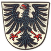
The town's arms might be described thus: Argent an eagle displayed sable armed and langued gules.
The eagle is the Imperial Eagle. The arms have their roots in the Imperial Freedom enjoyed by the Ingelheimer Grund (Ingelheim area).
Old coats of arms

- Nieder-Ingelheim: Argent a wall embattled gules masoned sable, issuant therefrom a demi-eagle displayed of the third beaked and langued of the second.
- Ober-Ingelheim: Argent an eagle displayed sable armed, beaked and langued gules.
Sponsorships
- Airbus Ingelheim am Rhein D-ABJE, Boeing 737-530, SN 25310/2126
- Until her decommissioning on 28 June 2001 there was a partnership with S58 Pinguin, a German Navy Fast Attack Craft.
Twin towns – sister cities
Ingelheim am Rhein is twinned with:[6]
 Stevenage, England, United Kingdom (1963)
 Autun, France (1963)
 San Pietro in Cariano, Italy (1984)
 Friedrichshain-Kreuzberg (Berlin), Germany (1971)
- Limbach-Oberfrohna, Germany (1990)
 Nysa, Poland (2002)
On 24 October 1975, the three-way partnership between Ingelheim, Autun and Stevenage was officially sealed.
Culture and sightseeing
Ingelheimer Fassenacht
There is in Ingelheim a well-developed carnival culture, which admittedly is very much under the Mainz carnival’s influence. All together, the town counts four Carnival clubs:
- Carneval-Verein "Wäschbächer" 1885
- Carnevalverein Frei-Weinheim
- Ingelheimer Carnevalverein
- Narrenclub Ingelheim 1987 ("Fools’ Club")
Museums
The Museum bei der Kaiserpfalz ("Museum at the Imperial Palace") has an exhibit dedicated to the Imperial Palace built in Ingelheim after 785 by Charlemagne. On show are small archaeological finds, objects from architectural sculpture and a demonstrative model of the once imposing building. Remnants of the Imperial Palace can be seen right near the museum. Of Europe-wide importance is the golden solidus found in 1996, which is hitherto still the only gold coin ever found struck with Charlemagne's effigy.[7]
Music
- Further Education Centre Symphony Orchestra
- Ingelheimer Konfettis (performing and singing group)
- Ingelheim church choir
- Bläserchöre Ingelheim (wind choirs)
- Carolus Magnus-Ingelheimer Kaiserpfalzbläser (wind ensemble)
- Telemann-Chor Ingelheim (choir)
Singing clubs
- GV Liederkranz 1857
- GV Einigkeit 1885
- GV Germania 1862
- MGV 1866
- Schubert-Quartett 1924 e.V.
- Boehringer Jazz & Pop Chor 2009
Buildings
The town has at its disposal a range of historical buildings worth seeing:
 Burgkirche
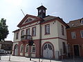 Ober-Ingelheim Old Town Hall
 Evangelical Church, built in 997 as Saint Peter's Chapel of the Imperial Palace.
 Uffhubtor
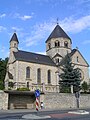 Selztaldom ("Selz Valley Cathedral")
 Saint Remigius's Church (Cath.) with Sebastian Münster statue
 The Aula Regia at Charlemagne’s Imperial Palace
 Malakoff tower
 Ohrenbrückertor
 Bismarck Tower


Others
- St. Michael with Plague Cross
- Carolingian aqueduct
- Heidesheimer Tor (gate)
- Bismarck Tower
- Ohrenbrücker Tor (gate)
- Jewish graveyard
- Old market hall in Nieder-Ingelheim
Parks
- Kommerzienrat-Boehringer-Anlage
- Emmerlingscher Park
- Rosengärtchen
- Uffhubtor-Anlage
Natural monuments

- Drifting chalk sands and dunes
In the cadastral areas of Nieder-Ingelheim and Frei-Weinheim, mainly north of the Autobahn along Konrad-Adenauer-Straße, but also south of the Autobahn – even within the Boehringer Ingelheim industrial lands – are found drifting chalk sands. Likewise a deposit is to be found in the area of the Griesmühle (mill).
These formations are under conservational protection under the Rhineland-Palatinate State Care Law. Damaging them or removing them, among other acts, is considered an incompensable encroachment on nature and the landscape. Municipal building uses in drifting chalk sand areas are therefore routinely excluded or only approved in very special cases. Two such exceptions were the building of Konrad-Adenauer-Straße (from the Autobahn bridge to Rheinstraße) and the building of the daycare centre on Sporkenheimer Straße.
Sport
- 1. Schwimmsportverein Ingelheim 1966 e.V. (swimming)
- RV Ingelheim
- SpVgg Ingelheim
- TUS Ober-Ingelheim
- Turngemeinde 1847 Corp. Nieder-Ingelheim (gymnastics)
- SV Ingelheim 1949 e.V.
- VfL Frei Weinheim
- HSC Ingelheim
- TV Frei-Weinheim (gymnastics)
- MFG-Ingelheim e.V. - Modellfluggruppe Ingelheim e.V.
- TSC Ingelheim
- FSC Ingelheim 07
Common welfare
- Mütter- und FamilienZentrum e.V. MütZe
The MütZe ("Mothers’ and Families’ Centre", with the abbreviation resembling the word Mütze – "cap") is to be found at the old Gymnasium. The MütZe takes upon itself a generation-spanning exchange for all Ingelheim residents. A babysitter exchange, handicraft classes, breakfast and lunch, housework and holiday support are regularly offered, as well as courses and events covering every family theme from babies to health to creativity.
In Ingelheim there are also a House of Youth (Haus der Jugend, although this is soon to become a shopping centre and will be replaced with another House of Youth) and a Mehrgenerationshaus.
Regular events
- Since 1972 there has been a yearly folk music event, the Eurofolkfestival Ingelheim, on the Burgkirche Fairgrounds. It is said to be one of the successor festivals to the famous Waldeck-Festivals. A great number of the visitors are people from the hippie culture and youths from the local area and from throughout Germany. The number of visitors varies from 2,000 to 3,000. It is usually held between mid-June and mid-July and always lasts from Friday to Sunday. Out of the Eurofolkfestival grew the OpenOhr Festival (a youth cultural festival) in Mainz in 1974 and 1975.
- Hafenfest auf der Jungau ("Harbour Festival on the Jungau"), each year in early August.
- Ingelheimer Rotweinfest ("Ingelheim Red Wine Festival") on the Burgkirche Fairgrounds, is held each year from the last weekend in September to the first weekend in October.
- Kerb in Groß-Winternheim ("kermis, or church consecration festival"), second weekend in September
- Internationale Tage ("International Days"), each year since 1959. Organized for Boehringer Ingelheim by François Lachenal till 1997.till 2000 curated by Patricia Rochat and since then by Ulrich Luckhardt.
- Umsonst-und-drinnen, international music festival for new blood groups.
- Kinderfest der DPSG Ingelheim ("Ingelheim DPSG Children’s Festival"), each year on Ascension Day since 1969 on the Jungau in Frei-Weinheim.
- Entekerb ("Harvest Kermis"), in October in Frei-Weinheim.
- Altstadtfest ("Old Town Festival"), second weekend in August, staged by NCI
- Fest der Generationen, second Saturday in September around the old Gymnasium, staged by the MütZe
Culinary specialities
Regional Rhenish-Hessian specialities are asparagus and morello cherries (a cultivar of sour cherries).
Economy and infrastructure
Transport
The Autobahn A 60 runs through the municipal area and has two interchanges there. Bundesstraße 41 ends in Ingelheim. The Autobahnen A 61 and A 63 lie right nearby. Frankfurt Airport can be reached by Autobahn in roughly 30 minutes. Frankfurt-Hahn Airport can be reached in roughly 50 minutes by Autobahnen A 60 and A 61 or Bundesstraße 50. A Bus to Hahn can be caught in Mainz
Ingelheim lies on the Mainz-Bingen-Cologne (West Rhine Railway) and Saarbrücken-Mainz-Frankfurt railway lines. Between Ingelheim-Nord and Oestrich-Winkel runs a Rhine ferry. The constituent communities and the surrounding municipalities are served by city and regional bus routes of Omnibusverkehr Rhein-Nahe GmbH. The local rail transport is served by the Rhein-Nahe-Nahverkehrsverbund.
Established businesses
- Boehringer Ingelheim, pharmaceutical enterprise
- Envision Entertainment GmbH, formerly EA Phenomic, a video game developer
- Goldener Engel, brewery
- Karl Gemünden, building company
- Rheinhessische Energie- und Wasserversorgungs-GmbH, energy and water supply
- Vereinigte Obst- und Gemüsemärkte (VOG), Europe's biggest transshipment centre for sour cherries
- WetterKontor, supplier of weather information
Agricultural produce
Of the 4,987-hectare municipal area, 641 ha is used for winegrowing and 1 373 ha is used for crops. The main agricultural produce is sour cherries, white asparagus and Wine. Although the town lies in a region dominated by white wine, 54.9% of the vineyard area in Ingelheim am Rhein is used for growing red wine varieties. With 641 ha in vineyards, the town is moreover one of Rhenish Hesse’s biggest winegrowing centres after Worms, (1,490 ha), Nierstein (783 ha), Alzey (769 ha), Westhofen (764 ha), Alsheim (704 ha) and Bechtheim (654 ha), and one of the biggest in the whole state of Rhineland-Palatinate.
"The red wines of Ingelheim and Heidesheim (…) opposite to Eltville (…) enjoy a high reputation."[3]
The Geisenheim Grape Breeding Institute’s vegetable farming department runs an experimental asparagus field in Ingelheim. The research results can be viewed on the Internet.[8]
Media
Local daily newspaper: Allgemeine Zeitung Ingelheim within the Rhein Main Presse, published by the Verlagsgruppe Rhein Main, Mainz.
Municipal television: "Blickpunkt Ingelheim", which is broadcast every Monday and Thursday on regional channel K3.
Public institutions
Since 1996, Ingelheim has been the seat of district administration for Mainz-Bingen.
Education
Ingelheim is home to:
- three primary schools (Präsident-Mohr-Grundschule, Theodor-Heuss-Grundschule, Brüder-Grimm-Grundschule)
- a combination primary school and Hauptschule (Pestalozzi-Grund- u. Hauptschule)
- a professional college, die BBS Ingelheim
- a school for those with learning difficulties (Albert-Schweitzer-Sonderschule)
- a Realschule (Kaiserpfalz-Realschule)
- an integrated comprehensive school (Kurt Schumacher)
- a Gymnasium (Sebastian-Münster-Gymnasium)
Under the umbrella of the Ingelheim Further Education Centre Weiterbildungszentrum Ingelheim the following institutions work:
- Volkshochschule (folk high school)
- Fridtjof-Nansen-Akademie für politische Bildung (political education)
- Music school
- Jugendbildungswerk (youth education)
Notable people
Honorary citizens
- Robert Boehringer, entrepreneur and lyricist, named an honorary citizen of Ingelheim in 1974
- Christian Rauch (1878–1976), archaeologist, named an honorary citizen of Ingelheim 16 December 1974
Sons and daughters of the town

- Sebastian Münster (1488–1552), scientist (cosmographer, Hebraist)
- Johannes Anspach (1752–1823), pastelist, draftsman, painter, owner of an artist's studio in the Netherlands
- Klaus Knopper (born 1968), developer of Linux distribution Knoppix
- Markus Kreuz (born 1977), footballer
Other celebrities
- Charlemagne, held court in Ingelheim in 807
- Louis the Pious, died in 840 in a summer tent on an island in the Rhine off Ingelheim
- The House of Ingelheim, among them Anselm Franz von Ingelheim, Archbishop of Mainz
- Jean-Baptiste Kléber, during the Siege of Mainz in 1793 headquartered in Ingelheim
- Eduard Douwes Dekker, known as Multatuli (2 March 1820 in Amsterdam – 19 February 1887 in Ingelheim am Rhein)
- Richard von Weizsäcker, from 1962 to 1966 managing partner of Boehringer Ingelheim
- Pope Joan, Johanna von Ingelheim, a perhaps real, perhaps fictitious figure
See also
Universal Synod of Ingelheim
References
- Wahlen der Bürgermeister der verbandsfreien Gemeinden, Landeswahlleiter Rheinland-Pfalz, accessed 30 July 2021.
- "Bevölkerungsstand 2020, Kreise, Gemeinden, Verbandsgemeinden". Statistisches Landesamt Rheinland-Pfalz (in German). 2021.
- Karl Baedeker, A Handbook for travellers on the Rhine, from Holland to Switzerland, Koblenz, 1864 - p. 279
- Ingelheim, Heidesheim und Wackernheim unterzeichnen Eingemeindungsvertrag, Allgemeine Zeitung vom 29. Februar 2016
- Deutscher Wetterdienst, Normalperiode 1961–1990
- "Städtepartnerschaften". ingelheim.de (in German). Ingelheim am Rhein. Retrieved 2021-02-15.
- Ingelheim Imperial Palace webpage Archived 2006-06-30 at the Wayback Machine
- Geisenheimer Online-Beratungssystem: [www.asparagus-info.org]
Further reading
- Hans-Georg Meyer; Gerd Mentgen: Sie sind mitten unter uns: zur Geschichte der Juden in Ingelheim. Ingelheim 1998 ISBN 3-924124-29-9
- Friedrich, Reinhard [Hrsg.]: Karl der Große in Ingelheim: Bauherr der Pfalz und europäischer Staatsmann; Katalog zur Ausstellung im Alten Rathaus Nieder-Ingelheim, 29. August bis 27. September 1998. Ingelheim 1998. ISBN 3-00-003290-8
- Landesamt für Vermessung und Geobasisinformation Rheinland-Pfalz: Ingelheim am Rhein. Topographische Karte 6014 (1:25.000). ISBN 3-89637-076-6
Documents
- picture of Oberingelheim from J.F. Dielmann, A. Fay, J. Becker (draughtsman): F.C. Vogels Panorama des Rheins, Bilder des rechten und linken Rheinufers, Lithographische Anstalt F.C. Vogel, Frankfurt 1833
External links
- Town’s official webpage (in German)
- Official Website of the Ingelheim Imperial Palace
- Deutsch-Israelischer Freundeskreis Ingelheim e.V. (in German)
- The Stevenage-Ingelheim-Autun Association

Authority control | |
|---|---|
| General | |
| National libraries | |
| Other | |
На других языках
[de] Ingelheim am Rhein
Ingelheim am Rhein ist eine große kreisangehörige Stadt im Landkreis Mainz-Bingen in Rheinland-Pfalz und seit 1996 Sitz der Verwaltung dieses Kreises. Sie ist gemäß Landesplanung als Mittelzentrum klassifiziert.- [en] Ingelheim am Rhein
[es] Ingelheim am Rhein
Ingelheim am Rhein es el centro administrativo del distrito de Maguncia-Bingen, situado en la ribera izquierda del Rin, situada en la región vitivinícola Rheinhessen, en el estado federal de Renania-Palatinado, Alemania. La ciudad tiene unos 35.000 habitantes. Acoge la sede central de Boehringer Ingelheim, una de las 20 mayores empresas farmacéuticas del mundo.[ru] Ингельхайм-ам-Райн
И́нгельхайм-ам-Райн[1] (нем. Ingelheim am Rhein) — город в Германии, районный центр, расположен в земле Рейнланд-Пфальц.Другой контент может иметь иную лицензию. Перед использованием материалов сайта WikiSort.org внимательно изучите правила лицензирования конкретных элементов наполнения сайта.
WikiSort.org - проект по пересортировке и дополнению контента Википедии