world.wikisort.org - Germany
Bingen am Rhein (German pronunciation: [ˈbɪŋən] (![]() listen)) is a town in the Mainz-Bingen district in Rhineland-Palatinate, Germany.
listen)) is a town in the Mainz-Bingen district in Rhineland-Palatinate, Germany.
Bingen am Rhein | |
|---|---|
Town | |
 | |
 Coat of arms | |
Location of Bingen am Rhein within Mainz-Bingen district  | |
 Bingen am Rhein  Bingen am Rhein | |
| Coordinates: 49°58′N 7°54′E | |
| Country | Germany |
| State | Rhineland-Palatinate |
| District | Mainz-Bingen |
| Subdivisions | 8 |
| Government | |
| • Lord mayor (2019–27) | Thomas Feser[1] (CDU) |
| Area | |
| • Total | 37.74 km2 (14.57 sq mi) |
| Elevation | 89 m (292 ft) |
| Population (2020-12-31)[2] | |
| • Total | 25,736 |
| • Density | 680/km2 (1,800/sq mi) |
| Time zone | UTC+01:00 (CET) |
| • Summer (DST) | UTC+02:00 (CEST) |
| Postal codes | 55411 |
| Dialling codes | 06721-06725 |
| Vehicle registration | MZ, BIN |
| Website | www.bingen.de |

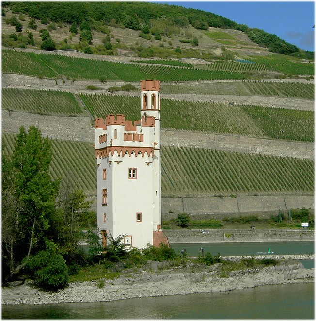
The settlement's original name was Bingium, a Celtic word that may have meant "hole in the rock",[3][citation needed] a description of the shoal behind the Mäuseturm, known as the Binger Loch. Bingen was the starting point for the Via Ausonia, a Roman military road that linked the town with Trier. Bingen is well known for, among other things, the story about the Mouse Tower, in which the Bishop of Hatto I of Mainz was allegedly eaten by mice. It was also the birthplace of Saint Hildegard von Bingen, an important polymath, abbess, mystic and musician, one of the most influential medieval composers and one of the earliest Western composers whose music is widely preserved and performed. Bingen am Rhein was also the birthplace of the celebrated poet Stefan George, along with many other influential figures.
Geography
Location
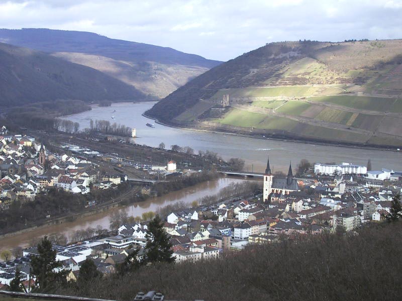
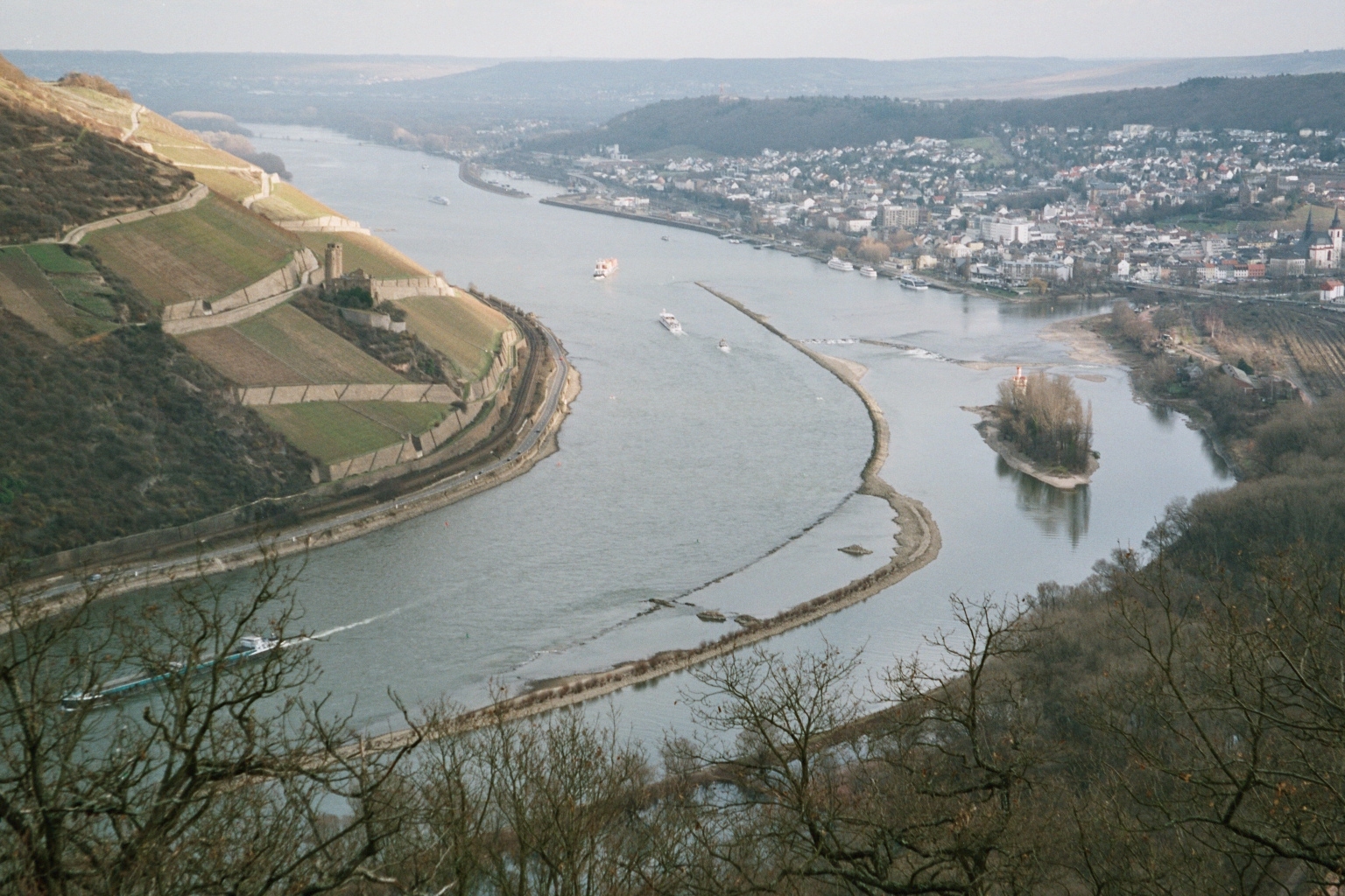
Bingen is situated just southeast of the Rhine knee by the Bingen Forest (Binger Wald – actually a low mountain range), which rises west of the town. Rising to the north on the other side of the Rhine is the Rheingau range, the Taunus's southwesternmost outcrop. In Bingen the river Nahe empties into the Rhine Gorge. Bingen forms the southern limit of the UNESCO Rhine Gorge World Heritage Site. The Rochusberg (mountain) is nearly completely surrounded by the town site.
Constituent communities
|
|
Population development
(each time at 31 December)
| Year | 1998 | 2000 | 2002 | 2004 | 2006 | 2008 | 2010 |
| Inhabitants | 24,821 | 24,710 | 24,786 | 24,849 | 24,587 | 24,398 | 25,833 |
History


Antiquity
Even before the Romans came, people lived here, because the location favoured transport, being at the confluence of the Nahe and Rhine Rivers, and the Rhine's entry into the gorge. The first settlement seems to have been a Celtic (Gaulish) settlement by the name of Binge – meaning "rift". In the early first century AD, Roman troops were stationed in Bingen on the Rhine Valley Road, and rendered the local name as Bingium in Latin. There the Romans erected a wooden bridge across the Nahe and constructed a bridgehead castrum. A Roman Mithraic monument, which included a mutilated sculpture representing the nativity of Mithra from a rock, was discovered in Bingen; one of its inscriptions is dated 236.[4]
Medieval period
The presbyter Aetherius of Bingen founded sometime between 335 and 360 a firmly Christian community. Bearing witness to this time is Aetherius's gravestone, which can still be seen in Saint Martin's Basilica.[5][6] After the fall of the Limes, the town became a Frankish royal estate and passed in 983 by the Donation of Verona from Otto II to Archbishop Willigis of Mainz.[7] Under Otto III the Binger Kammerforst (forest) came into being. Under Willigis, some way up the river Nahe, the stone Drususbrücke (bridge) was built.[8]
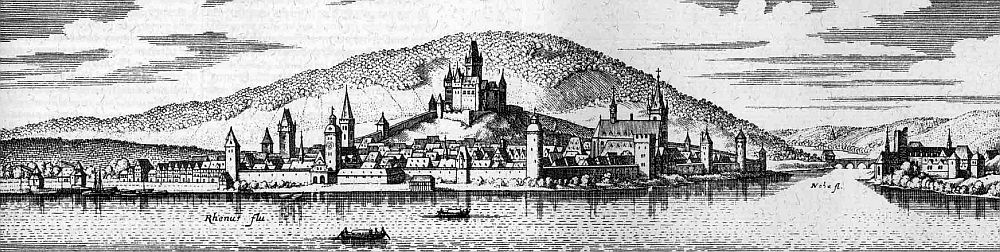
The inhabitants of Bingen strove time and again for independence, which led in 1165 through disputes between the Archbishop of Mainz and the Emperor to destruction. In the 13th century, Bingen was a member of the Rhenish League of Towns. The building of Klopp Castle (Burg Klopp) in the mid 13th century could well be seen as being tied in with this development. A last attempt was the town's unsuccessful participation in the German Peasants' War in 1525. From the Archbishop the Cathedral Chapter of Mainz acquired the town in two halves in 1424 and 1438. Until the late 18th century Bingen remained under its administration. Like many towns in the valley, Bingen suffered several town fires and wars.
Modern period
From 1792 to 1813, the town was, as part of the département of Mont-Tonnerre (or Donnersberg – both names meaning "Thunder Mountain"), French after French Revolutionary troops had occupied the Rhine's left bank. In 1816, after the Congress of Vienna, the town passed to the Grand Duchy of Hesse-Darmstadt while today's outlying centre of Bingerbrück went to Prussia's Rhine Province, making Bingen a border town until 1871, when the German Empire was founded.
On 7 June 1969, the formerly Prussian[9] municipality of Bingerbrück was amalgamated. On 22 April 1972 came Dromersheim's and Sponsheim's amalgamation with Bingen. The epithet am Rhein has been borne since 1 July 1982.[10]
For the State Garden Show in 2008 in Bingen, the Rhineside areas in the town underwent extensive modernization.
Jewish history
Benjamin of Tudela mentioned a Jewish community in Bingen in the mid-12th century. Christian inhabitants attacked the small Jewish quarter on Rosh Hashanah in 1198 or 1199, and the Jews were driven from the city. Jews again lived in Bingen as moneylenders in the middle of the 13th century under the jurisdiction of the archbishop of Mainz. In 1343, French Jews settled in Bingen. In 1405, the archbishop declared a moratorium on one-fifth of the debts owed to Jews by Christians, and subsequently the archbishops repeatedly extorted large sums. Noted rabbis who taught in the small community included Seligmann Oppenheim, who convened the Council of Bingen (1455–56) in an unsuccessful attempt to establish his authority over the whole of Rhineland Jewry. After the proposal was opposed by Moses Minz, the matter was referred to Isaac Isserlein, who rejected the project. The Jews were again expelled from Bingen in 1507, and did not return until the second half of the 16th century. The Jewish population was 465 in 1933, and 222 in 1939 due to flight and emigration. The 169 Jews who remained in Bingen in 1942 were deported, and only four ultimately returned. The synagogue was demolished in 1945, and the community was not reestablished after World War II.[11]
Politics
Town council
The council is made up of 36 members. The mayor since 2012 has been the CDU politician Thomas Feser. Seats are apportioned thus:[12]
| SPD | CDU | FDP | Grüne | FWG | Linke | Total | |
| 2019 | 11 | 11 | 3 | 6 | 3 | 2 | 36 seats |
| 2014 | 12 | 16 | 2 | 4 | 2 | - | 36 seats |
| 2009 | 10 | 16 | 4 | 4 | 2 | - | 36 seats |
| 2004 | 10 | 18 | 3 | 3 | 2 | - | 36 seats |
Coat of arms
The town's arms show Saint Martin cutting off a piece of his cloak for a poor man and, in a small inescutcheon in dexter chief, the Wheel of Mainz.

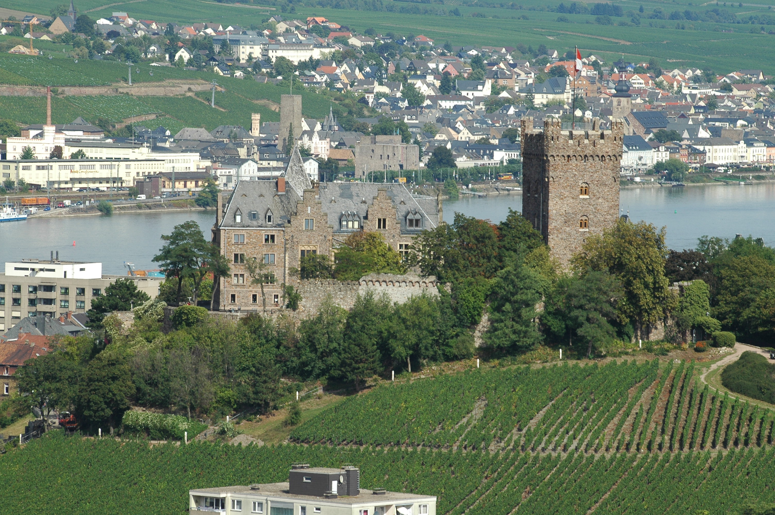
Main sights
- Mouse Tower
- Former monastery church, the Basilica of St. Martin, from the 15th century with Romanesque crypt
- Klopp Castle (Burg Klopp)
- Rochuskapelle
- Drususbrücke (bridge) with Romanesque bridge chapel
- Old Rhine Crane
- Haferkasten (“Oat Shed”, from after 1689) with Stefan-George-Museum
- Puricellipalais, an Empire style building from 1780
- Old Graveyard from the 19th century with Napoleon monument
- Historical Museum on the theme “Hildegard of Bingen”
- Roman villa rustica in the Bingen Forest
- Rhine Floodplain Special Protection Area
- Bingerbrück Reiter Signal Box technological cultural monument
- A new concept was introduced with the Route der Industriekultur Rhein-Main (“Rhine-Main Industrial Culture Route”), along which industrial building works on the 160 km between Miltenberg and Bingen are linked together into an adventure route about the Industrial Age in southern Germany.[13] Already 700 buildings are scientifically catalogued.
Culture
Bingen 2008 State Garden Show
Bingen was from 18 April to 19 October 2008 host for the Rhineland-Palatinate State Garden Show. The event was held along a 2.8 km stretch of the Rhine waterfront on 24 ha of exhibition area. With 1.3 million visitors, the expected number of 600,000 was greatly exceeded.[14]
Regular events
- Bingen swingt – jazz festival
- Binger Open Air Festival – Alternative festival
- Breakpoint – worldwide, one of the demoscene's biggest events (no longer held)
- Nacht der Verführung – (literally "Night of Seduction") wine festival in the vines
- Rhein im Feuerzauber – great firework event
- Rochusfest (Saint Roch's Festival) – church festival with folk character, Bishopric of Mainz pilgrimage
- Winzerfest (winemakers' festival) – lasting 11 days, the longest wine festival on the Rhine
Economy and infrastructure

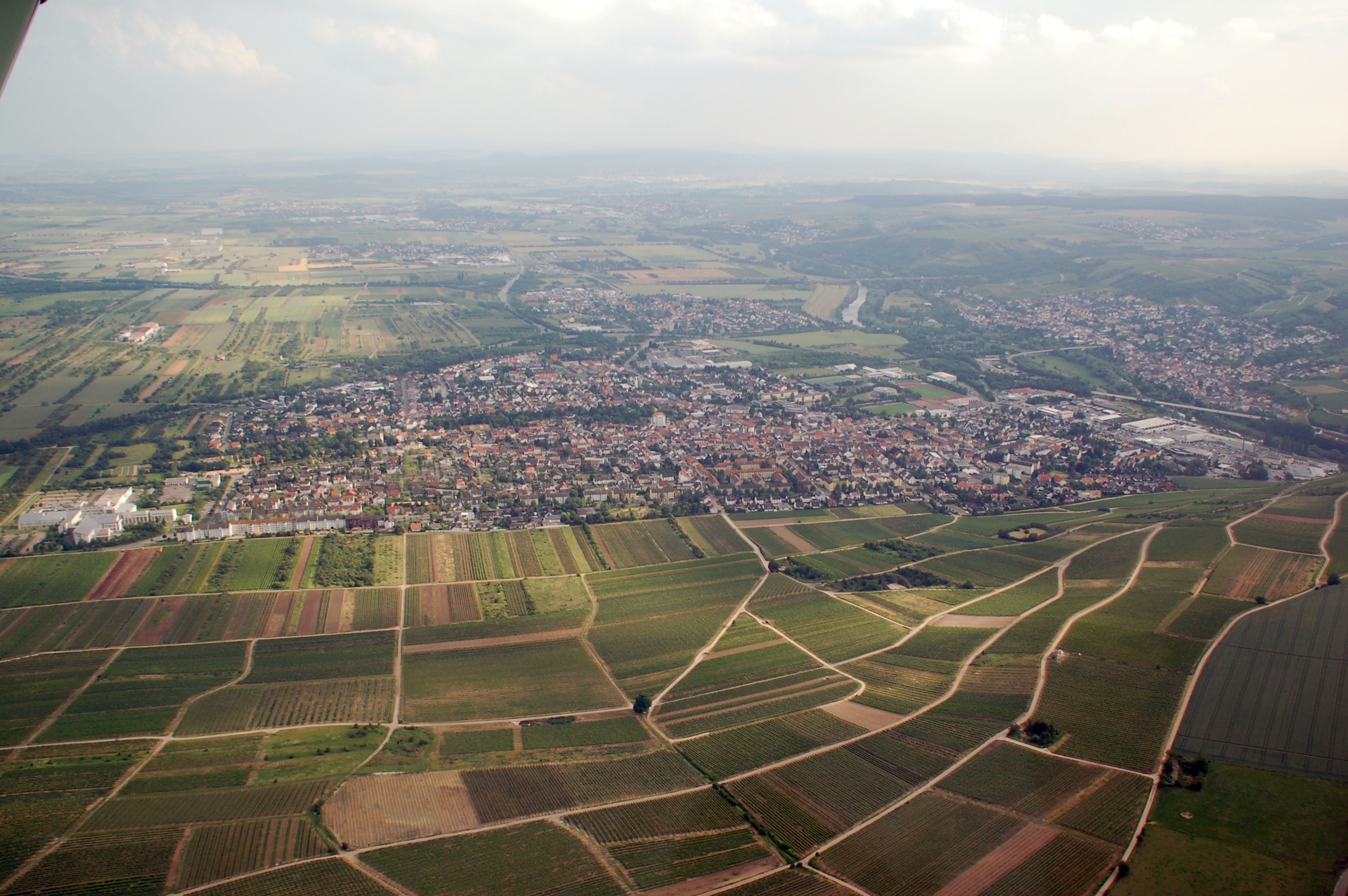
The region is characterized economically by winegrowing, especially as in Bingen three winegrowing areas (Rheinhessen, Mittelrhein and Nahe) meet. The town is also the winegrowing Bereich's (Bereich Bingen) namesake in German wine law.
Other industries that once did business in Bingen when there was a harbour have left the town over the years. The service industries here today are found Italic textmainly in the industrial park (Autobahn interchange Bingen-Ost / Kempten / Industriegebiet) and in the Scharlachberg commercial park.
Tourism also plays an important role.
Resident businesses
- NSM-Löwen (slot machines)
- Oerlikon Balzers Coating Germany GmbH
- Sekthaus Carl Graeger
Transport
Rail
The main railway station, Bingen (Rhein) Hauptbahnhof, lies in the outlying centre of Bingerbrück. It is served by InterCity trains as well as one ICE line.
Bingen (Rhein) Stadt station lies 2 km farther east, right across from the historical harbour crane. This station is important only for local transport. There is also a stop in Bingen-Gaulsheim. The reason that two railway stations arose in Bingen is historical. The main railway station was originally a Prussian border station built by the Rhenish Railway Company on its West Rhine Railway, whilst the station in town belonged to the Hessian Ludwig Railway.
The stops at Drususbrücke on the Bingen Hbf-Bad Kreuznach line and Bingen-Kempten and Büdesheim-Dromersheim on the Bingen/Rhein Stadt–Alzey line are no longer served.
Road
Bingen lies next to Autobahnen A 60 and A 61, which are linked to the town by Bundesstraße 9.
Water
Only private transport is still of importance today. The cargo harbour has been abandoned. The former winter harbour is now a marina.
There are landing stages of the tourist lines Köln-Düsseldorfer, Bingen-Rüdesheimer Fahrgastschifffahrt and Rösslerlinie. A passenger ferry and a car ferry link Bingen with Rüdesheim.
Until the late 1970s Bingen was a piloting station.
Education
- University of Applied Sciences Bingen
- Stefan-George-Gymnasium
- Hildegardisschule, Bishopric of Mainz Catholic private school
- Rochus-Realschule
- Rupertus Hauptschule
- Berufsbildende Schule Bingen (vocational school)
- Bingen town library
- Folk high school


Notable people
Born before 1900
- Hildegard of Bingen (1098–1179), abbess and author, mystic, writer, composer, musician, and medic. After her the Bingen girls' school (Gymnasium and vocational school), the Hildegardisschule (“Higa”), is named. On 7 October 2012, Pope Benedict XVI named her a Doctor of the Church.
- Bertha of Bingen (c. 600's)
- Joseph Albrecht von Ittner (1754–1825), writer
- Philipp Foltz (1805–1877), painter
- Ferdinand Allmann (1828–1912), Mayor of Bingen and Member of the Landstände of the Grand Duchy of Hesse
- Heinrich Brück (1831–1903), Bishop of Mainz
- Johann Baptist Hilsdorf (1835–1918), photographer and father of Theodor and Jacob
- Karl Johann Brilmayer (1843–1905), Catholic priest, writer and Rhenish Hessian local historian
- Alice Bensheimer (1864–1935), politician and feminist
- Theodor Hilsdorf (1868–1944), photographer
- Stefan George (1868–1933), poet
- Carl Friedberg (1872–1955), pianist and music pedagogue
- Jacob Hilsdorf (1872–1916), photographer
- Pankraz Blank (born 1882), Member of the Landtag (Zentrum)
- Saladin Schmitt (1883–1951), theatre researcher, producer and theatre manager
- Fritz Nathan (1891–1960), leading Jewish architect who designed synagogues, department stores, and the first skyscraper in Mannheim[15]
Born 1900 and later
- Max Richter (geologist) (1900–1983), geologist and paleontologist, professor at the Freie Universität Berlin
- August Weimer (1908–1980), trade unionist and politician (CDU), Member of the Bundestag
- Anton Philipp Brück (1913–1984), ecclesiastical historian, librarian at the Martinus-Bibliothek
- Günter Duffrer (born 1922), docent for pastoral liturgy at the Episcopal Seminary, diocesan president of church choirs in the Bishopric of Mainz
- Claire Marienfeld (born 1940), politician, former Bundestag Armed Forces Commissioner
- Mary Roos (born 1949), singer and actress
- Tina York (born 1954), singer
- Thomas Kling (1957–2005), lyric poet
- Peter Frey (born 1957), journalist
- Frank Schröder (actor) (born 1964), singer and actor
- Dajan Šimac (born 1982), footballer
- Jan Schlaudraff (born 1983), footballer and first national player from Bingen
Twin towns – sister cities
Bingen am Rhein is twinned with:[16]
 Hitchin, England, United Kingdom (1958)
 Nuits-Saint-Georges, France (1960)
- Venarey-les-Laumes, France (1967)
 Prizren, Kosovo (1968)
 Anamur, Turkey (2011)
 Kutná Hora, Czech Republic (2011)
References
- Wahlen der Bürgermeister der verbandsfreien Gemeinden, Landeswahlleiter Rheinland-Pfalz, accessed 30 July 2021.
- "Bevölkerungsstand 2020, Kreise, Gemeinden, Verbandsgemeinden". Statistisches Landesamt Rheinland-Pfalz (in German). 2021.
- "Bingen am Rhein | the Rhine Valley". Archived from the original on 2015-04-27. Retrieved 2015-01-14.
- Sidney N. Deane (1924). "Archaeological News". American Journal of Archaeology. 28 (3 Àdate=July–September 1924): 344. doi:10.2307/497748. JSTOR 497748. S2CID 245275207.
- Hans Ulrich Instinsky: Die Grabinschrift des Presbyters Aetherius von Bingen, in: JbBistumMainz 5, 1950, pages 305–309
- Ein alter Stein in regionalgeschichte.net Archived April 16, 2009, at the Wayback Machine
- Heinrich Gottfried Philipp Gengler: Regesten und Urkunden zur Verfassungs- und Rechtsgeschichte der deutschen Städte im Mittelalter, Erlangen 1863, S. 224.
- Chisholm, Hugh, ed. (1911). . Encyclopædia Britannica. Vol. 3 (11th ed.). Cambridge University Press.
- "Bingen - regionalgeschichte.net". www.regionalgeschichte.net.
- Statistisches Landesamt Rheinland-Pfalz – Amtliches Gemeindeverzeichnis 2006 Archived 2011-07-18 at the Wayback Machine
- "Bingen". www.jewishvirtuallibrary.org.
- Rheinland-Pfalz, Statistisches Landesamt. "LWL RLP - Kommunalwahlen: Ergebnisse der Ratswahlen: Wahlergebnisse 2019: Stadt- und Gemeinderatswahlen". wahlen.rlp.de.
- Neue Wege zur alten Industriekultur Archived 2016-01-28 at the Wayback Machine. Frankfurter Rundschau on 27 Nov. 2006
- "realtime.at - Domain gecatcht". www.landesgartenschau-bingen-2008.de.
- "Guide to the Fritz Nathan (1891-1960)Collection, 1914-2000AR 1443 / MF 533". findingaids.cjh.org.
- "Partnerstädte". bingen.de (in German). Bingen am Rhein. Retrieved 2021-02-10.
External links
- Town's official webpage (in German)
- Tourist Information on Bingen am Rhein
- Information on Bingen
- Jewish Encyclopedia: "Bingen" by Kaufmann Kohler & A. M. Friedenberg (1906).
- Jewish History of Bingen (in German)

Authority control | |
|---|---|
| General | |
| National libraries | |
| Other |
|
На других языках
[de] Bingen am Rhein
Bingen am Rhein ist eine große kreisangehörige Stadt im Landkreis Mainz-Bingen in Rheinland-Pfalz. Der ursprüngliche Name der Siedlung war Bingium, keltisches Wort eventuell für „Loch im Fels“, Bezeichnung für die Untiefe hinter dem Mäuseturm, bekannt als Binger Loch. Bingen war Ausgangspunkt der Ausoniusstraße, einer römischen Militärstraße, welche die Stadt mit Trier verband. Bekannt ist Bingen unter anderem durch die Geschichte um den Binger Mäuseturm, in dem angeblich der Mainzer Erzbischof Hatto von Mäusen gefressen wurde. 2008 war Bingen Ausrichter der dritten rheinland-pfälzischen Landesgartenschau nach Kaiserslautern und Trier.- [en] Bingen am Rhein
[es] Bingen am Rhein
Bingen del Rin, o Bingen, es una ciudad alemana que pertenece al estado federal de Renania-Palatinado. Está situada en la confluencia de los ríos Rin y Nahe al oeste de Alemania y, cerca de la ciudad de Maguncia.[ru] Бинген (Рейнланд-Пфальц)
Би́нген[1][2][3], Бинген-ам-Райн[lower-alpha 1] (нем. Bingen am Rhein) — город в Германии, в земле Рейнланд-Пфальц.Другой контент может иметь иную лицензию. Перед использованием материалов сайта WikiSort.org внимательно изучите правила лицензирования конкретных элементов наполнения сайта.
WikiSort.org - проект по пересортировке и дополнению контента Википедии