world.wikisort.org - Germany
Geilenkirchen (German pronunciation: [ˈɡaɪlənkɪʁçn̩] (![]() listen), Ripuarian: Jellekerke [ˈjæləˌkæʀ˦(ə)kə]) is a town in the district Heinsberg, in North Rhine-Westphalia, Germany. It is situated near the border with the Netherlands, on the river Wurm, approx. 15 km (9.3 mi) north-east of Heerlen and 20 km (12.4 mi) north of Aachen.
listen), Ripuarian: Jellekerke [ˈjæləˌkæʀ˦(ə)kə]) is a town in the district Heinsberg, in North Rhine-Westphalia, Germany. It is situated near the border with the Netherlands, on the river Wurm, approx. 15 km (9.3 mi) north-east of Heerlen and 20 km (12.4 mi) north of Aachen.
Geilenkirchen | |
|---|---|
Town | |
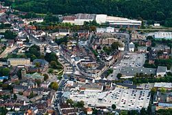
 Aerial view | |
 Coat of arms | |
Location of Geilenkirchen within Heinsberg district  | |
 Geilenkirchen  Geilenkirchen | |
| Coordinates: 50°57′55″N 6°07′10″E | |
| Country | Germany |
| State | North Rhine-Westphalia |
| Admin. region | Köln |
| District | Heinsberg |
| Subdivisions | 13 |
| Government | |
| • Mayor (2020–25) | Daniela Ritzerfeld[1] (Ind.) |
| Area | |
| • Total | 83 km2 (32 sq mi) |
| Elevation | 95 m (312 ft) |
| Population (2020-12-31)[2] | |
| • Total | 27,518 |
| • Density | 330/km2 (860/sq mi) |
| Time zone | UTC+01:00 (CET) |
| • Summer (DST) | UTC+02:00 (CEST) |
| Postal codes | 52511 |
| Dialling codes | 02451; 02453; 02462 |
| Vehicle registration | HS, ERK, GK |
| Website | www.geilenkirchen.de |
It was the site of Operation Clipper in November 1944.
The town gives its name to nearby NATO Air Base Geilenkirchen. The base is home to 17 E-3A airborne early warning and control aircraft manned by crews from 14 nations.
On July 24, 2019 the highest temperature ever recorded in Germany was measured in Geilenkirchen with 40.5 °C (104.9 °F) during a heat wave that affected much of Europe.[3] The record was broken the following day when temperature in Lingen reached 42.6 °C (108.7 °F).[4]
Born in Geilenkirchen
- Ludolf Camphausen (1803–1890), banker, Prussian minister president in the revolutionary year 1848
- Otto von Camphausen (1812–1896), Prussian Finance Minister
- Christoph Dohmen (born 1957), professor of the Old Testament at the University of Regensburg
- Hans Meyer (1900–1962), German physician and ministerial official
- Max Wilms (1867–1918), German physician and surgeon
References
- Wahlergebnisse in NRW Kommunalwahlen 2020, Land Nordrhein-Westfalen, accessed 21 June 2021.
- "Bevölkerung der Gemeinden Nordrhein-Westfalens am 31. Dezember 2020" (in German). Landesbetrieb Information und Technik NRW. Retrieved 21 June 2021.
- Waidner, Jannik. "In Geilenkirchen in NRW: 40,5 Grad – Neuer Hitzerekord in Deutschland". Faz.net – via www.faz.net.
- "Neuer Hitzerekord: 42,6 °C in Lingen (Emsland)!". www.nwzonline.de.
На других языках
- [en] Geilenkirchen
[ru] Гайленкирхен
Гайленкирхен (нем. Geilenkirchen) — город в Германии, в земле Северный Рейн-Вестфалия, входит в состав района Хайнсберг.Другой контент может иметь иную лицензию. Перед использованием материалов сайта WikiSort.org внимательно изучите правила лицензирования конкретных элементов наполнения сайта.
WikiSort.org - проект по пересортировке и дополнению контента Википедии
