world.wikisort.org - Germany
Deißlingen is a municipality of the district of Rottweil of Baden-Württemberg, Germany.
Deißlingen | |
|---|---|
Municipality | |
 The Deißlinger Hagenstall | |
 Coat of arms | |
Location of Deißlingen within Rottweil district 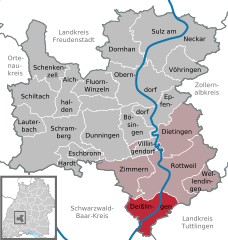 | |
 Deißlingen  Deißlingen | |
| Coordinates: 48°06′48″N 08°36′22″E | |
| Country | Germany |
| State | Baden-Württemberg |
| Admin. region | Freiburg |
| District | Rottweil |
| Area | |
| • Total | 32.16 km2 (12.42 sq mi) |
| Elevation | 611 m (2,005 ft) |
| Population (2020-12-31)[1] | |
| • Total | 6,235 |
| • Density | 190/km2 (500/sq mi) |
| Time zone | UTC+01:00 (CET) |
| • Summer (DST) | UTC+02:00 (CEST) |
| Postal codes | 78652 |
| Dialling codes | 07420 |
| Vehicle registration | RW |
| Website | www |
History
In 1802-03, Deißlingen, a possession of the Free Imperial City of Rottweil, and Lauffen ob Rottweil, a property of Rottenmünster Abbey, were mediatized to the Electorate, later Kingdom, of Württemberg. Deißlingen was assigned to a newly organized Oberamt at Rottweil, and Lauffen to Oberamt Spaichingen. Lauffen joined Deißlingen in Rottweil's jurisdiction on 27 October 1810. The district was reorganized on 1 October 1938 as Landkreis Rottweil, to which the two towns were still assigned. On 1 January 1974, Lauffen was incorporated into Deißlingen and a new municipality formed.[2]
Geography
The municipality (Gemeinde) of Deißlingen covers 32.15 square kilometers (12.41 sq mi) of the Rottweil district of Baden-Württemberg, which assigns Deißlingen to the metropolitan area of Villingen-Schwenningen, Tuttlingen, and Rottweil. Deißlingen is physically located in a transitional landscape between the muschelkalk-keuper plateaus of the Upper Gäu to the north, the Swabian Jura to the east, and the Baar to the south. Elevation above sea level in the municipal area ranges from a high of 753 meters (2,470 ft) Normalnull (NN) at the border with Tuttlingen district to a low of 574 meters (1,883 ft) NN on the Neckar as it forms the border with Rottweil.[2]
The forested slopes of the Neckar and Mückenbach river valleys were declared Federally-protected landscapes in 1953. They were joined in 1990 by the Eschach valley.[2]
Politics
Deißlingen has two boroughs (Ortsteile): Deißlingen and Lauffen.[2]
Coat of arms
The municipal coat of arms for Deißlingen shows a blue wolfsangel upon a field of yellow, with a black bar at the top containing a yellow stag antler, a clear reference to Württemberg. The wall anchor is a motif associated with Lauffen ob Rottweil's as early as 1780. This coat of arms is a combination of those of the towns of Deißlingen and Lauffen, with a change made to the chief to comply with the rule of tincture. The Rottweil district office approved the official use of the coat of arms and issued a corresponding municipal flag on 10 December 1981.[2]
References
- "Bevölkerung nach Nationalität und Geschlecht am 31. Dezember 2020" [Population by nationality and sex as of December 31, 2020] (CSV). Statistisches Landesamt Baden-Württemberg (in German). June 2021. Retrieved 17 October 2021.
- "Deißlingen". LEO-BW (in German). Baden-Württemberg. Retrieved 24 July 2020.
External links
- Official website
 (in German)
Towns and municipalities in Rottweil (district) | ||
|---|---|---|
На других языках
- [en] Deißlingen
[ru] Дайслинген
Дайслинген (нем. Deißlingen) — коммуна в Германии, в земле Баден-Вюртемберг.Другой контент может иметь иную лицензию. Перед использованием материалов сайта WikiSort.org внимательно изучите правила лицензирования конкретных элементов наполнения сайта.
WikiSort.org - проект по пересортировке и дополнению контента Википедии