world.wikisort.org - Germany
Blankenfelde-Mahlow is a municipality in the Teltow-Fläming district of Brandenburg, Germany. It is situated approximately 3 kilometres (2 miles) south of Berlin.
Blankenfelde-Mahlow | |
|---|---|
Municipality | |
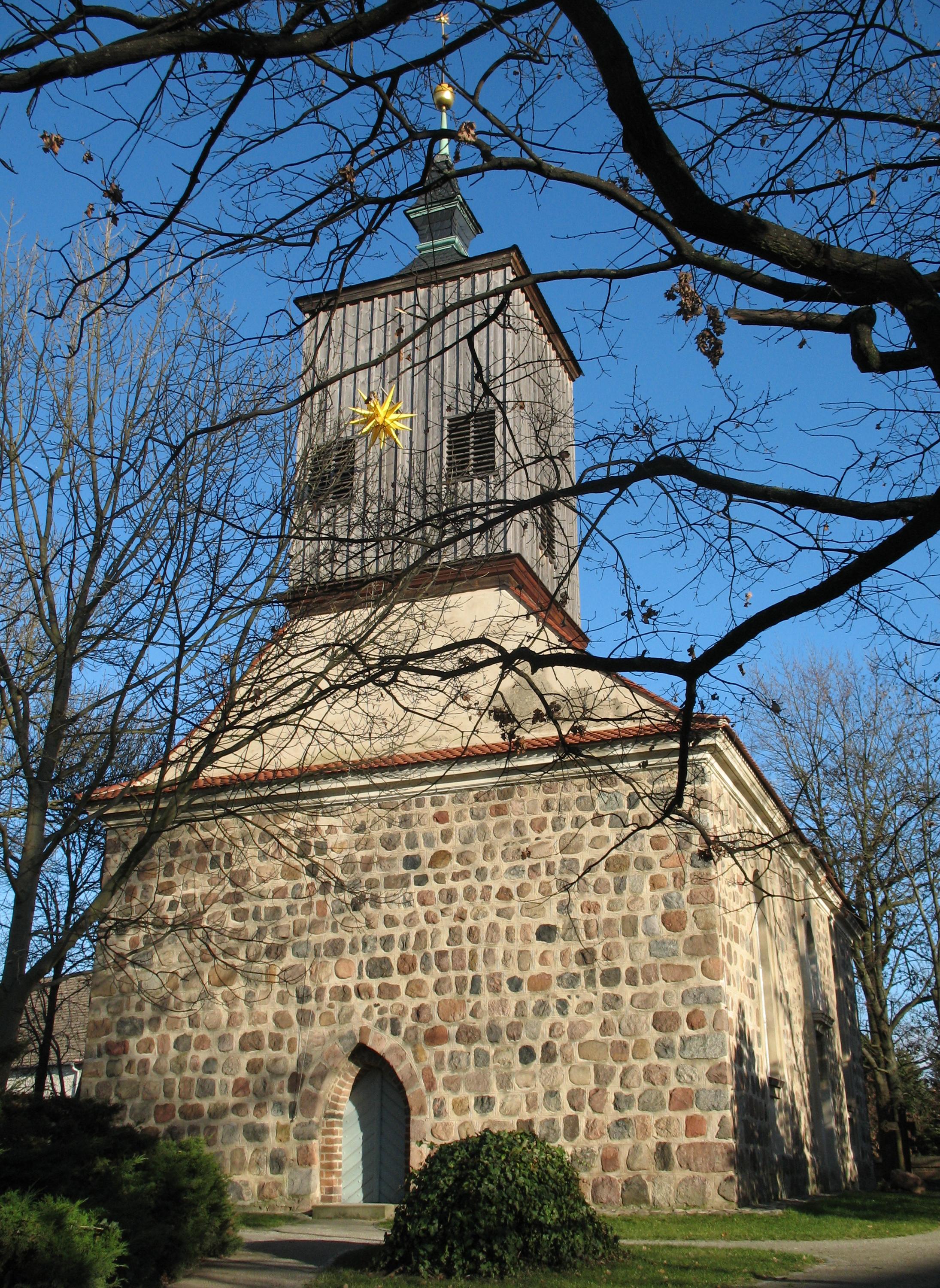
Church in Blankenfelde | |
Location of Blankenfelde-Mahlow within Teltow-Fläming district | |
 Blankenfelde-Mahlow  Blankenfelde-Mahlow | |
| Coordinates: 52°21′00″N 13°24′00″E | |
| Country | Germany |
| State | Brandenburg |
| District | Teltow-Fläming |
| Government | |
| • Mayor (2019–27) | Michael Schwuchow[1] (SPD) |
| Area | |
| • Total | 54.89 km2 (21.19 sq mi) |
| Elevation | 43 m (141 ft) |
| Population (2020-12-31)[2] | |
| • Total | 28,606 |
| • Density | 520/km2 (1,300/sq mi) |
| Time zone | UTC+01:00 (CET) |
| • Summer (DST) | UTC+02:00 (CEST) |
| Postal codes | 15827, 15831 |
| Dialling codes | 03379 |
| Vehicle registration | TF |
| Website | www.blankenfelde-mahlow.de |
History
The municipality shared its borders with the former West Berlin, and so during the period 1961-1990 it was separated.
Blankenfelde
Blankenfelde was first mentioned in documents in 1375. However, a substantial part of this district, the so-called Gagfah settlement, did not develop until the 1930s, after the Süd-Berlin Bodenaktiengesellschaft had acquired and parceled out the area. As a result, the population increased significantly - from 766 inhabitants in 1930 to 6228 inhabitants in 1939.
Mahlow
Mahlow was first mentioned in documents in 1287. After the place had received a station in 1875, the immigration of wealthy Berliners. Its constituency is under Teltow from 1945 until its dissolution in 1952. As early as 1950, the community Glasow was merged with the community Mahlow. The construction of the Berlin Wall from 13 August 1961, the S-Bahn links were cut to Berlin. Only after the fall of the Wall in 1989 did these connections get going again. On 31 August 1992, the S-Bahn connection was restored with the gap closing the Dresden railway between Lichtenrade and Mahlow.
Demography
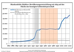 Development of population since 1875 within the current Boundaries (Blue Line: Population; Dotted Line: Comparison to Population development in Brandenburg state; Grey Background: Time of Nazi Germany; Red Background: Time of communist East Germany)
 Recent Population Development and Projections (Population Development before Census 2011 (blue line); Recent Population Development according to the Census in Germany in 2011 (blue bordered line); Official projections for 2005–2030 (yellow line); for 2017–2030 (scarlet line); for 2020–2030 (green line)


|
|
|
Transport
Blankenfelde-Mahlow is located on the federal highway B 96 between the Berlin state border (district Tempelhof-Schöneberg) and Zossen, the state road L 40 between Potsdam and King Wusterhausen and the L 76 to Teltow. The nearest motorway junction is Rangsdorf on the Federal Highway 10 (southern Berliner Ring).
Since 1992, Blankenfelde-Mahlow is with the stations Mahlow and Blankenfelde (Kr Teltow-Fläming) again with the S-Bahn line 2 from Berlin on the Dresden train, after this originally to Rangsdorf going connection in 1961 in the course of the construction of the Berlin Wall and separated was set. Terminus is now Blankenfelde.
With the regional train you can reach Blankenfelde and Dahlewitz via the Regional Express lines RE 5 Rostock / Stralsund-Berlin-Elsterwerda / Wünsdorf-Waldstadt and RE 7 Dessau-Berlin-Wünsdorf-Waldstadt.
In the immediate vicinity there is the airport Berlin-Schönefeld (SXF), which was extended to Berlin Brandenburg Airport (BER), which is not yet in operation. It will be reachable from Blankenfelde-Mahlow by train or car in fifteen minutes.
Twin towns – sister cities
Blankenfelde-Mahlow is twinned with:[4]
Notable people
- Manfred Görg (1938–2012), Catholic theologian and egyptologist
- Hans-Joachim Hacker (born 1949), politician (SPD)
- Jan-Michael Feustel (1951–2009), art historian and author
- Dietmar Klemt, politician (SPD), mayor and official director 1992–2003
References
- Landkreis Teltow-Fläming Wahl der Bürgermeisterin / des Bürgermeisters, accessed 4 July 2021.
- "Bevölkerung im Land Brandenburg nach amtsfreien Gemeinden, Ämtern und Gemeinden 31. Dezember 2020". Amt für Statistik Berlin-Brandenburg (in German). June 2021.
- Detailed data sources are to be found in the Wikimedia Commons.Population Projection Brandenburg at Wikimedia Commons
- "Partnerstädte". blankenfelde-mahlow.de (in German). Blankenfelde-Mahlow. Retrieved 2021-03-05.
Towns and municipalities in Teltow-Fläming | ||
|---|---|---|
 | ||
На других языках
[de] Blankenfelde-Mahlow
Blankenfelde-Mahlow ist eine amtsfreie Gemeinde im nördlichen Teil des Landkreises Teltow-Fläming in Brandenburg.- [en] Blankenfelde-Mahlow
[es] Blankenfelde-Mahlow
Blankenfelde-Mahlow es un municipio situado en el distrito de Teltow-Fläming, en el estado federado de Brandeburgo (Alemania), a una altitud de 40 metros. Su población a finales de 2016 era de unos 27 000 habs. y su densidad poblacional, 500 hab/km².[1][2][ru] Бланкенфельде-Малов
Бланкенфельде-Малов (нем. Blankenfelde-Mahlow) — коммуна в Германии, в земле Бранденбург.Другой контент может иметь иную лицензию. Перед использованием материалов сайта WikiSort.org внимательно изучите правила лицензирования конкретных элементов наполнения сайта.
WikiSort.org - проект по пересортировке и дополнению контента Википедии