world.wikisort.org - Germany
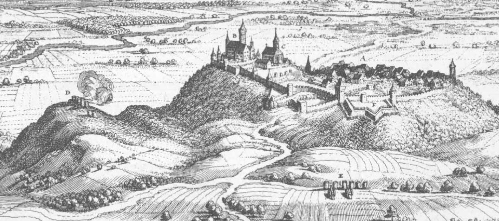
Amöneburg (German pronunciation: [aˈmøːnəbʊʁk] (![]() listen)) is a town in the Marburg-Biedenkopf district in Hesse, Germany. It lies on a mountain and is built around the castle of the same name, Burg Amöneburg.
listen)) is a town in the Marburg-Biedenkopf district in Hesse, Germany. It lies on a mountain and is built around the castle of the same name, Burg Amöneburg.
Amöneburg | |
|---|---|
Town | |
 View of the town from the east | |
 Coat of arms | |
Location of Amöneburg within Marburg-Biedenkopf district 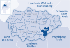 | |
 Amöneburg  Amöneburg | |
| Coordinates: 50°47′52″N 8°55′23″E | |
| Country | Germany |
| State | Hesse |
| Admin. region | Gießen |
| District | Marburg-Biedenkopf |
| Government | |
| • Mayor (2017–23) | Michael Plettenberg[1] (Ind.) |
| Area | |
| • Total | 43.95 km2 (16.97 sq mi) |
| Elevation | 365 m (1,198 ft) |
| Population (2020-12-31)[2] | |
| • Total | 4,980 |
| • Density | 110/km2 (290/sq mi) |
| Time zone | UTC+01:00 (CET) |
| • Summer (DST) | UTC+02:00 (CEST) |
| Postal codes | 35287 |
| Dialling codes | 06422 |
| Vehicle registration | MR |
| Website | www.amoeneburg.de |
Geography
Location
Amöneburg lies on a basalt cone that can be seen from a great distance, below which flows the river Ohm, a tributary to the Lahn. From the Vogelsberg massif in the southeast, Amöneburg is split by the Amöneburg Basin, a hollow suspected of being a meteorite crater. In the southwest rise the Lahn Mountains.
Neighbouring communities
In the north, Amöneburg borders on the town of Kirchhain, in the east on the town of Stadtallendorf (both in Marburg-Biedenkopf), in the southeast on the town of Homberg (Vogelsbergkreis), and in the west on the community of Ebsdorfergrund (Marburg-Biedenkopf).
Communities within town
- Erfurtshausen
- Mardorf
- Roßdorf
- Rüdigheim
Coat of arms
Amöneburg's coat of arms, like many throughout western Germany, depicts the Wheel of Mainz and Saint Martin of Tours patron saint of the diocese of Mainz cutting off a piece of his cloak for a poor man.
History
Findings from digs have suggested that the area was already settled in the New Stone Age. It is supposed that in Celtic times there was a town (or oppidum) here. In 721, Saint Boniface built a small monastery and a church below the castle.
At the beginning of the 12th century, much of Hesse belonged to Thuringia. The Thuringian lands, however, were so widely scattered that quite often they were interspersed with estates belonging to the Archbishopric of Mainz and its vassals. The parish of Amöneburg belonged to the archbishopric until 1803.
Amöneburg's rectangular market square was laid out in this shape in the 18th century. Also worth seeing is the Mainzer Hof with its barn and manor house at the Lindauer Tor (gate).
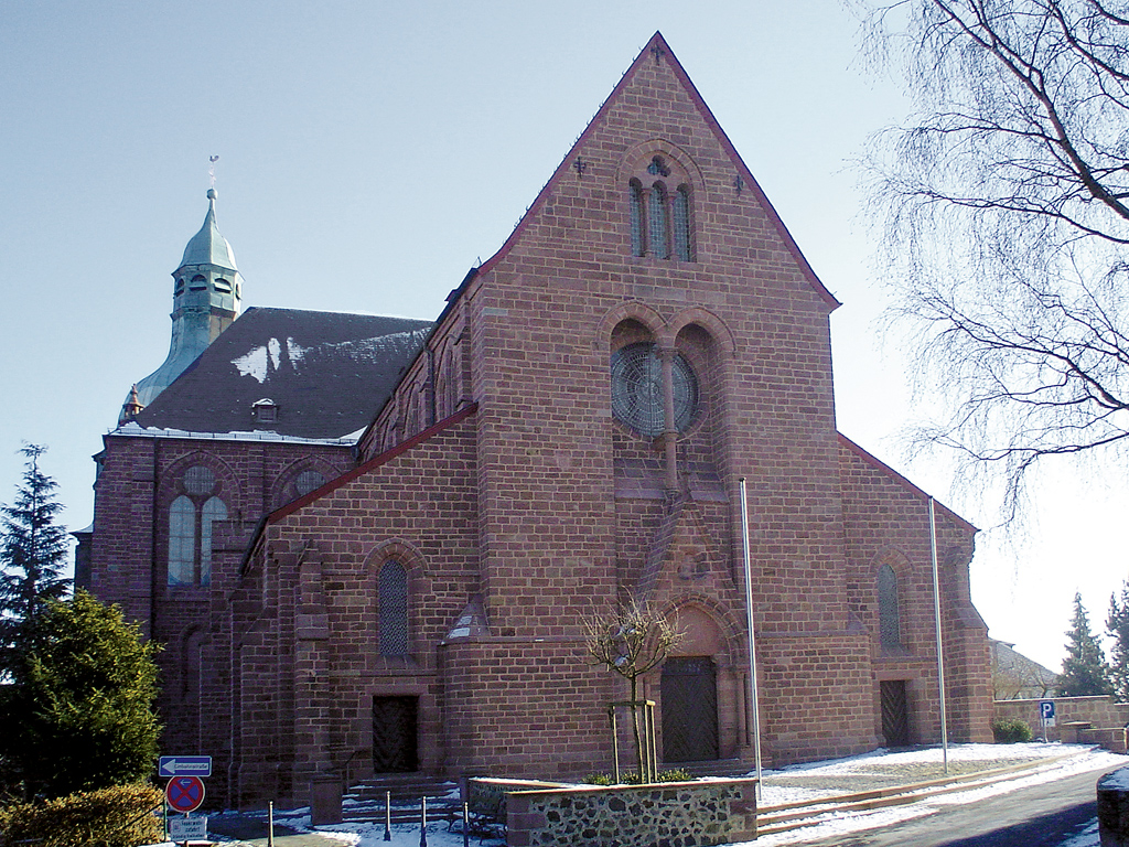
The adjoining church is a neo-Gothic basilica. On its north side stands the 14th-century church tower with its Baroque cupola.
Around the knoll that forms the townsite runs the town wall, still preserved to a great extent. A loop road offers good views of the surrounding countryside.
At the southeastern foot of the crags on which the town is built lies the Brückermühle, and old mill, with an old stone bridge (Ohmbrücke) across the river Ohm, which was an historically important crossing. It is known from the Hessians' and Brunswickers' fight against the French in 1762, recalled nowadays by a Baroque obelisk in the yard outside the Brückerwirtshaus (inn).
In June 1646 Imperialist forces took the town by treaty.[3]
Abandonments
Around Amöneburg, the abandoned communities of Brück, Brunsfort, Gerende, Heuchelheim, Lindau, Radenhausen and Wanehusen may be found.
Politics
Mayors
- 1996-2002: Oliver Haupt
- 2002-2005: Anders Arendt
- 2005-today: Michael Richter-Plettenberg
Town council
As of municipal elections held on March 6, 2016, town council seats are apportioned thus:[4]
| CDU | 11 seats |
| SPD | 6 seats |
| FWG (citizens' coalition) | 6 seats |
Transport
Somewhat north of Amöneburg runs Federal Highway B 62 (Biedenkopf - Alsfeld) with connections to B 454 to Schwalmstadt and B 3 towards Marburg. The nearest railway connections is 5 km north, in Kirchhain.
Regular events
- Kirchweihfest (Church dedication festival, yearly, last weekend in August, organized by local clubs)
Museums
Museum Amöneburg: Prehistory and early history of the Amöneburg Basin, agricultural history, mediaeval fortifications and finds from digs, models and dioramas with explanatory notices, and in the attic rooms a nature preservation information centre.
Personalities

- Saint Boniface (around 673-754 or 755), founded 721 founded a monastery cell below the castle Amöneburg and began the Christianization of Upper Hesse from Amöneburg
- Johannes Eisermann, (1486-1558), (born in Amönenburg), called Ferrarius Montanus, religious scholar, jurist and first rector of the University of Marburg.
- Ludwig Schick (born 1949), auxiliary bishop in Fulda from 1998 to 2002, since 2002 Archbishop of Bamberg, visited in Amöneburg the seminary St. Johann.
Town partnerships
 Château Garnier, France, since 1974
 Tragwein, Austria
 Tuoro sul Trasimeno, Italy, since 1987
There has also been a common "ring" partnership among these towns since 1997.
References
- "Ergebnisse der letzten Direktwahl aller hessischen Landkreise und Gemeinden" (XLS) (in German). Hessisches Statistisches Landesamt. 5 September 2022.
- "Bevölkerung in Hessen am 31.12.2020 nach Gemeinden". Hessisches Statistisches Landesamt (in German). June 2021.
- Helfferich, Tryntje, The Thirty Years War: A Documentary History (Cambridge, 2009), p. 300.
- "Kommunalwahlen 2016 in Hessen". www.statistik-hessen.de. Archived from the original on 13 June 2016. Retrieved 22 May 2022.
External links
Towns and municipalities in the district of Marburg-Biedenkopf | ||
|---|---|---|
 | ||
Authority control | |
|---|---|
| General | |
| National libraries | |
На других языках
[de] Amöneburg
Amöneburg .mw-parser-output .IPA a{text-decoration:none}[aˈmøːnəbʊrk] ist eine Kleinstadt im mittelhessischen Landkreis Marburg-Biedenkopf. Sie liegt auf dem 365 m hohen Berg Amöneburg mit der Burg Amöneburg am Gipfel. Die Stadt hat ihren Namen ursprünglich von dem in der Nähe vorbeifließenden Fluss Ohm und von der auf der Kuppe des ehemaligen Vulkans liegenden Burg.- [en] Amöneburg
[ru] Амёнебург
Амёнебург (нем. Amöneburg) — город в Германии, в земле Гессен. Подчинён административному округу Гиссен. Входит в состав района Марбург-Биденкопф. Население составляет 5162 человека (на 31 декабря 2010 года).[1] Занимает площадь 43,95 км². Официальный код — 06 5 34 001.Другой контент может иметь иную лицензию. Перед использованием материалов сайта WikiSort.org внимательно изучите правила лицензирования конкретных элементов наполнения сайта.
WikiSort.org - проект по пересортировке и дополнению контента Википедии