world.wikisort.org - France
Saint-Jean-de-Sixt (Arpitan: Sent-Jian-de-Sixt) is a commune in the Haute-Savoie department in the Auvergne-Rhône-Alpes region in southeastern France.
Saint-Jean-de-Sixt | |
|---|---|
Commune | |
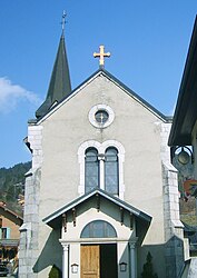
 The church in Saint-Jean-de-Sixt | |
Location of Saint-Jean-de-Sixt  | |
 Saint-Jean-de-Sixt  Saint-Jean-de-Sixt | |
| Coordinates: 45°55′26″N 6°24′38″E | |
| Country | France |
| Region | Auvergne-Rhône-Alpes |
| Department | Haute-Savoie |
| Arrondissement | Annecy |
| Canton | Faverges |
| Intercommunality | Vallées de Thônes |
| Government | |
| • Mayor (2020–2026) | Didier Lathuille[1] |
| Area 1 | 12.21 km2 (4.71 sq mi) |
| Population | 1,461 |
| • Density | 120/km2 (310/sq mi) |
| Time zone | UTC+01:00 (CET) |
| • Summer (DST) | UTC+02:00 (CEST) |
| INSEE/Postal code | 74239 /74450 |
| Elevation | 828–1,860 m (2,717–6,102 ft) (avg. 963 m or 3,159 ft) |
| 1 French Land Register data, which excludes lakes, ponds, glaciers > 1 km2 (0.386 sq mi or 247 acres) and river estuaries. | |
It lies in the Aravis Range of the French Alps. The inhabitants are the Saintjeandais or Saintjeandins.
The village used to be called Villaret, when it was a part of the Kingdom of Savoy, prior to its incorporation into France in 1860.
Nearby
Nearby villages include Manigod, Thônes, Le Grand Bornand, La Clusaz and the larger Chamonix and Annecy.
Notable inhabitants
- Saint Peter Faber, S.J., one of the founders of the Jesuit Order, was born here.
See also
References
- "Répertoire national des élus: les maires". data.gouv.fr, Plateforme ouverte des données publiques françaises (in French). 9 August 2021.
- "Populations légales 2019". The National Institute of Statistics and Economic Studies. 29 December 2021.
External links
Wikimedia Commons has media related to Saint-Jean-de-Sixt.
На других языках
- [en] Saint-Jean-de-Sixt
[es] Saint-Jean-de-Sixt
Saint-Jean-de-Sixt es una población y comuna francesa, en la región de Ródano-Alpes, departamento de Alta Saboya, en el distrito de Annecy y cantón de Thônes.Текст в блоке "Читать" взят с сайта "Википедия" и доступен по лицензии Creative Commons Attribution-ShareAlike; в отдельных случаях могут действовать дополнительные условия.
Другой контент может иметь иную лицензию. Перед использованием материалов сайта WikiSort.org внимательно изучите правила лицензирования конкретных элементов наполнения сайта.
Другой контент может иметь иную лицензию. Перед использованием материалов сайта WikiSort.org внимательно изучите правила лицензирования конкретных элементов наполнения сайта.
2019-2025
WikiSort.org - проект по пересортировке и дополнению контента Википедии
WikiSort.org - проект по пересортировке и дополнению контента Википедии