world.wikisort.org - France
Saint-Avold (French pronunciation: [sɛ̃.t‿avɔld]; German: Sankt Avold; Lorraine Franconian: Sänt Avuur) is a commune in the Moselle department in Grand Est in north-eastern France.[3]
This article may be expanded with text translated from the corresponding article in French. (August 2018) Click [show] for important translation instructions.
|
Saint-Avold | |
|---|---|
Commune | |
 Eastern end of Abbey of Saint-Nabor | |
 Coat of arms | |
Location of Saint-Avold  | |
 Saint-Avold  Saint-Avold | |
| Coordinates: 49°06′37″N 6°42′38″E | |
| Country | France |
| Region | Grand Est |
| Department | Moselle |
| Arrondissement | Forbach-Boulay-Moselle |
| Canton | Saint-Avold |
| Intercommunality | CA Saint-Avold Synergie |
| Government | |
| • Mayor (2020–2026) | René Steiner[1] |
| Area 1 | 35.48 km2 (13.70 sq mi) |
| Population | 15,415 |
| • Density | 430/km2 (1,100/sq mi) |
| Time zone | UTC+01:00 (CET) |
| • Summer (DST) | UTC+02:00 (CEST) |
| INSEE/Postal code | 57606 /57500 |
| Elevation | 215–383 m (705–1,257 ft) |
| 1 French Land Register data, which excludes lakes, ponds, glaciers > 1 km2 (0.386 sq mi or 247 acres) and river estuaries. | |
It is situated twenty-eight miles (45 km) east of Metz, France and seventeen miles (27 km) southwest of Saarbrücken, Germany.
History
The Saint-Avold area has frequently suffered invasions and since the nineteenth century has been controlled alternately by German and French authorities.
The original Abbey of Saint Nabor began as an oratory for a sixth-century monastery. Gradually a complex developed after it received the relics of Saint Nabor, and the church was rebuilt in the eighteenth century, in part following Baroque style. It was designated as a basilica.
During the French Revolution, the monastery and church suffered extensive damage; the cloisters were destroyed. The ancient parish church was sacrificed in exchange for keeping Saint Nabor. The abbey also suffered bombing damage during World War II, but much of the church has been restored.
The Saint-Avold Synagogue is a Jewish synagogue near Place Paul-Collin. The current synagogue building, completed in 1956, replaces a nearby synagogue which was also destroyed during World War II.
Population
| Year | Pop. | ±% p.a. |
|---|---|---|
| 1968 | 16,280 | — |
| 1975 | 17,955 | +1.41% |
| 1982 | 16,485 | −1.21% |
| 1990 | 16,533 | +0.04% |
| 1999 | 16,922 | +0.26% |
| 2007 | 16,611 | −0.23% |
| 2012 | 16,349 | −0.32% |
| 2017 | 15,483 | −1.08% |
| Source: INSEE[4] | ||
Lorraine American Cemetery
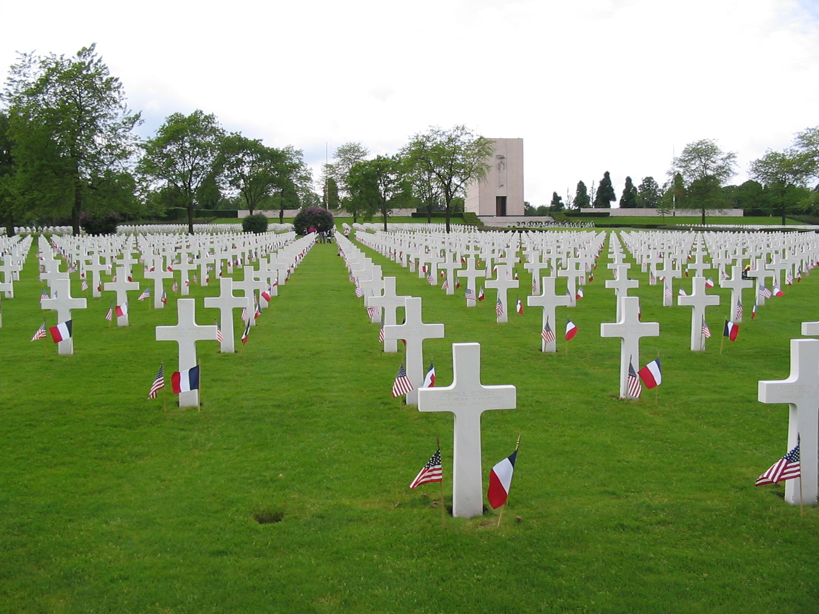
Just north of the town is the site of Europe's largest United States' World War II military cemetery, the Lorraine American Cemetery and Memorial, with the graves of 10,489 American soldiers who died during World War II. Most of the men were killed during the United States' drive to expel German forces from the fortress city of Metz toward the Siegfried Line and the Rhine River. The soldiers were mostly from the U.S. Seventh Army's Infantry and Armored divisions and its cavalry groups.[5]
Climate
Climate in this area has mild differences between highs and lows, and there is adequate rainfall year-round. The Köppen Climate Classification subtype for this climate is "Cfb" (Marine West Coast Climate/Oceanic climate).[6]
| Climate data for Saint-Avold | |||||||||||||
|---|---|---|---|---|---|---|---|---|---|---|---|---|---|
| Month | Jan | Feb | Mar | Apr | May | Jun | Jul | Aug | Sep | Oct | Nov | Dec | Year |
| Average high °C (°F) | 4 (39) |
6 (42) |
11 (52) |
15 (59) |
19 (67) |
22 (72) |
24 (76) |
24 (75) |
21 (69) |
15 (59) |
9 (48) |
4 (40) |
14 (58) |
| Average low °C (°F) | −2 (29) |
−2 (29) |
1 (34) |
4 (40) |
8 (46) |
11 (52) |
13 (55) |
13 (55) |
10 (50) |
6 (42) |
2 (36) |
−1 (31) |
6 (42) |
| Average precipitation cm (inches) | 5.1 (2) |
4.1 (1.6) |
4.8 (1.9) |
4.6 (1.8) |
5.1 (2) |
5.8 (2.3) |
6.9 (2.7) |
6.4 (2.5) |
5.6 (2.2) |
6.6 (2.6) |
6.1 (2.4) |
6.4 (2.5) |
67 (26.4) |
| Source: Weatherbase [7] | |||||||||||||
Sister cities
|
Notable people
- Louis Aloyse Risse (1850–1925), engineer born in Saint-Avold who designed the Grand Concourse in the Bronx in New York.
- Erich Isselhorst, (1906–1948), Nazi war criminal, executed in Strasbourg in 1948
- Adrienne Thomas (1897–1980), novelist.
- Umut Bozok, (1996–), footballer
See also
References
- "Répertoire national des élus: les maires". data.gouv.fr, Plateforme ouverte des données publiques françaises (in French). 2 December 2020.
- "Populations légales 2019". The National Institute of Statistics and Economic Studies. 29 December 2021.
- INSEE commune file
- Population en historique depuis 1968, INSEE
- "Lorraine American Cemetery and Memorial", American Battle Monument Commission
- Climate Summary for Saint-Avold, France
- "Weatherbase.com". Weatherbase. 2013. Retrieved on July 6, 2013.
External links
- History of Saint Avold
- Saint-Avold, France Web site
- Photo of Saint Nabor Basilica
- Sociéte d'Histoire du Pays Naborien
Authority control | |
|---|---|
| General |
|
| National libraries | |
| Other |
|
На других языках
[de] Saint-Avold
Vorlage:Infobox Gemeinde in Frankreich/Wartung/abweichendes Wappen in Wikidata- [en] Saint-Avold
[es] Saint-Avold
Saint-Avold es una población y comuna francesa, en la región de Lorena, departamento de Mosela, en el distrito de Forbach y cantones de Saint-Avold-1 y Saint-Avold-2.[fr] Saint-Avold
Saint-Avold [sɛ̃t‿avɔld][1] est une commune française située dans le département de la Moselle, en Lorraine, au sein de la nouvelle entité administrative Grand Est.[it] Saint-Avold
Saint-Avold (in tedesco Sankt Avold, in lorenese Sänt Avuur) è un comune francese di 16.753 abitanti situato nel dipartimento della Mosella nella regione del Grand Est.[ru] Сент-Авольд
Сент-Аво́льд (фр. Saint-Avold, нем. Sankt Avold) — город во французском департаменте Мозель, регион Эльзас — Шампань — Арденны — Лотарингия, округ Форбак — Буле-Мозель, кантон Сент-Авольд. До марта 2015 года город являлся административным центром упразднённых кантонов Сент-Авольд-1 и Сент-Авольд-2 (округ Форбак).Другой контент может иметь иную лицензию. Перед использованием материалов сайта WikiSort.org внимательно изучите правила лицензирования конкретных элементов наполнения сайта.
WikiSort.org - проект по пересортировке и дополнению контента Википедии