world.wikisort.org - France
Poligny (French pronunciation: [pɔliɲi] (![]() listen)) is a commune in the Jura department in Bourgogne-Franche-Comté in eastern France.[3]
listen)) is a commune in the Jura department in Bourgogne-Franche-Comté in eastern France.[3]
Poligny | |
|---|---|
Commune | |
 A general view of Poligny | |
 Flag  Coat of arms | |
Location of Poligny  | |
 Poligny  Poligny | |
| Coordinates: 46°50′12″N 5°42′31″E | |
| Country | France |
| Region | Bourgogne-Franche-Comté |
| Department | Jura |
| Arrondissement | Dole |
| Canton | Poligny |
| Intercommunality | CC Arbois, Poligny, Salins - Coeur du Jura |
| Government | |
| • Mayor (2020–2026) | Dominique Bonnet[1] |
| Area 1 | 50.22 km2 (19.39 sq mi) |
| Population | 4,003 |
| • Density | 80/km2 (210/sq mi) |
| Time zone | UTC+01:00 (CET) |
| • Summer (DST) | UTC+02:00 (CEST) |
| INSEE/Postal code | 39434 /39800 |
| Elevation | 252–626 m (827–2,054 ft) |
| 1 French Land Register data, which excludes lakes, ponds, glaciers > 1 km2 (0.386 sq mi or 247 acres) and river estuaries. | |
The town stands at the foot of the first plateau of the Jura region, with limestone cliffs rising to its east and south, and a steephead valley leading to the village of Vaux-sur-Poligny to the east. On the cliffs to the east is a notable cave, known as "Le Trou de la Lune" (the Moonhole); on the cliffs to the south is a large cross, the "Croix du Dan". A network of hiking trails surrounds the town and provide routes to both these viewpoints, and the GR 59 long distance footpath runs through the town.
First Empire general Jean-Pierre Travot was born in Poligny; a statue in his honour stands in the principal square of the town, the Place des Déportés, and a road is named after him.
Poligny is served by the railway line from Besançon to Lons-le-Saunier.
The town is recognised as the "Capital of Comté", with a third of the region's production of this much-loved cheese being aged in the town's cellars. The town is also surrounded by vineyards, and is home to a number of independent wine producers as well as a cooperative.
Population
|
|
Gallery
 Croix du Dan
 Général Travot
 Collégiale St.Hippolyte
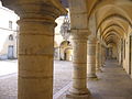 Convent des Ursulines
 Mouthier le Vieillard
 Wladimir Gagneur
 Tower of Paravis
 Tower of the "Sergenterie"
 Le Moon hole
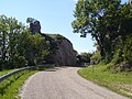 La "Roche Percée"


See also
References
- "Répertoire national des élus: les maires". data.gouv.fr, Plateforme ouverte des données publiques françaises (in French). 2 December 2020.
- "Populations légales 2019". The National Institute of Statistics and Economic Studies. 29 December 2021.
- INSEE commune file
External links
- . Encyclopædia Britannica (11th ed.). 1911.
Authority control | |
|---|---|
| National libraries | |
| Other |
|
This Jura geographical article is a stub. You can help Wikipedia by expanding it. |
Другой контент может иметь иную лицензию. Перед использованием материалов сайта WikiSort.org внимательно изучите правила лицензирования конкретных элементов наполнения сайта.
WikiSort.org - проект по пересортировке и дополнению контента Википедии