world.wikisort.org - France
Orée-d'Anjou (French pronunciation: [ɔʁe dɑ̃ʒu] (![]() listen), literally Edge of Anjou) is a commune in the Maine-et-Loire department of western France. Champtoceaux is the municipal seat.
listen), literally Edge of Anjou) is a commune in the Maine-et-Loire department of western France. Champtoceaux is the municipal seat.
Orée-d'Anjou | |
|---|---|
Commune | |
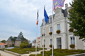
 The town hall of Champtoceaux with the towers of the château in the background | |
Location of Orée-d'Anjou  | |
 Orée-d'Anjou  Orée-d'Anjou | |
| Coordinates: 47°20′13″N 1°15′50″W | |
| Country | France |
| Region | Pays de la Loire |
| Department | Maine-et-Loire |
| Arrondissement | Cholet |
| Canton | Mauges-sur-Loire |
| Intercommunality | Mauges Communauté |
| Government | |
| • Mayor (2022–2026) | André Martin[1] |
| Area 1 | 156.34 km2 (60.36 sq mi) |
| Population | 16,429 |
| • Density | 110/km2 (270/sq mi) |
| Time zone | UTC+01:00 (CET) |
| • Summer (DST) | UTC+02:00 (CEST) |
| INSEE/Postal code | 49069 /49270, 49530 |
| 1 French Land Register data, which excludes lakes, ponds, glaciers > 1 km2 (0.386 sq mi or 247 acres) and river estuaries. | |
History
It was established on 15 December 2015 and consists of the former communes of Bouzillé, Champtoceaux, Drain, Landemont, Liré, Saint-Christophe-la-Couperie, Saint-Laurent-des-Autels, Saint-Sauveur-de-Landemont and La Varenne.[3]
Population
| Year | Pop. | ±% p.a. |
|---|---|---|
| 1968 | 9,678 | — |
| 1975 | 10,315 | +0.91% |
| 1982 | 11,153 | +1.12% |
| 1990 | 11,863 | +0.77% |
| 1999 | 12,296 | +0.40% |
| 2007 | 14,440 | +2.03% |
| 2012 | 15,824 | +1.85% |
| 2017 | 16,413 | +0.73% |
| Populations of the area corresponding with the commune of Orée-d'Anjou at 1 January 2020. Source: INSEE[4] | ||
See also
References
Wikimedia Commons has media related to Orée d'Anjou.
- "Répertoire national des élus: les maires" (in French). data.gouv.fr, Plateforme ouverte des données publiques françaises. 13 September 2022.
- "Populations légales 2019". The National Institute of Statistics and Economic Studies. 29 December 2021.
- Arrêté préfectoral, 25 November 2015 (in French)
- Population en historique depuis 1968, INSEE
На других языках
[de] Orée d’Anjou
Orée d’Anjou ist eine französische Gemeinde mit 16.025 Einwohnern im Département Maine-et-Loire in der Region Pays de la Loire. Die Gemeinde gehört zum Arrondissement Angers und zum Kanton Mauges-sur-Loire. Die Einwohner werden Oréens genannt.- [en] Orée-d'Anjou
[fr] Orée d'Anjou
Orée d'Anjou est, depuis le 15 décembre 2015, une commune nouvelle française, située dans le département de Maine-et-Loire, en région Pays de la Loire[1].Текст в блоке "Читать" взят с сайта "Википедия" и доступен по лицензии Creative Commons Attribution-ShareAlike; в отдельных случаях могут действовать дополнительные условия.
Другой контент может иметь иную лицензию. Перед использованием материалов сайта WikiSort.org внимательно изучите правила лицензирования конкретных элементов наполнения сайта.
Другой контент может иметь иную лицензию. Перед использованием материалов сайта WikiSort.org внимательно изучите правила лицензирования конкретных элементов наполнения сайта.
2019-2025
WikiSort.org - проект по пересортировке и дополнению контента Википедии
WikiSort.org - проект по пересортировке и дополнению контента Википедии