world.wikisort.org - France
Ménil-Hermei (French pronunciation: [menil ɛʁmɛ] (![]() listen)) is a commune in the Orne department in the Normandy region of north-western France.
listen)) is a commune in the Orne department in the Normandy region of north-western France.
Ménil-Hermei | |
|---|---|
Commune | |
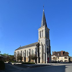
 The church in Ménil-Hermei | |
Location of Ménil-Hermei  | |
 Ménil-Hermei  Ménil-Hermei | |
| Coordinates: 48°49′38″N 0°19′30″W | |
| Country | France |
| Region | Normandy |
| Department | Orne |
| Arrondissement | Argentan |
| Canton | Athis-Val de Rouvre |
| Intercommunality | Val d'Orne |
| Government | |
| • Mayor (2020–2026) | Katia Halluin |
| Area 1 | 6.61 km2 (2.55 sq mi) |
| Population | 205 |
| • Density | 31/km2 (80/sq mi) |
| Time zone | UTC+01:00 (CET) |
| • Summer (DST) | UTC+02:00 (CEST) |
| INSEE/Postal code | 61267 /61210 |
| Elevation | 63–216 m (207–709 ft) (avg. 171 m or 561 ft) |
| 1 French Land Register data, which excludes lakes, ponds, glaciers > 1 km2 (0.386 sq mi or 247 acres) and river estuaries. | |
Administration
The mayor is Katia Halluin, elected in 2020.
Demography
| Year | Pop. | ±% p.a. |
|---|---|---|
| 1968 | 208 | — |
| 1975 | 203 | −0.35% |
| 1982 | 210 | +0.49% |
| 1990 | 176 | −2.18% |
| 1999 | 155 | −1.40% |
| 2007 | 190 | +2.58% |
| 2012 | 211 | +2.12% |
| 2017 | 203 | −0.77% |
| Source: INSEE[2] | ||
History
- In 1321, Jean de Corday bought the fief of Mesnil-Hermey.
- In 1465, the title of nobility of Raoul de Corday du Mesnil-Hermé is confirmed.
- In 1505, Marguerite - the daughter of Guillaume "Raoult", Esquire, Lord of Mesnil-Hermey - marries Thomas Williamson, a Scottish knight staying in France with the French king, Charles VIII).
- In the 18th century, the land of Mesnil-Hermey belonged to the Marquis de Rabodanges.
Places of interest
- The valley of the river Orne with:
- the raised stone which bygone people named: "Pierre à Gargantua".
- the rock called "Bec Corbin", dominating the river, at the foot of which passed the old stone road from Domfront to Falaise, via Durcet, La Forêt-Auvray and Ménil-Hermei.
Between these two towns, the road followed (unlike the current asphalt road) the route of the old path of "Bougas". It was by this route that the imposing stone pedestal of the monument to William the Conqueror, erected at the foot of Falaise Castle in 1850, was sent, causing considerable difficulties for the horse teams between "Forest Bridge" and Ménil-Hermei.
- The Lavoir (washing place) of "La Vieville"
- Another lavoir
- The interior of the lavoir
See also
References
- "Populations légales 2019". The National Institute of Statistics and Economic Studies. 29 December 2021.
- Population en historique depuis 1968, INSEE
Wikimedia Commons has media related to Ménil-Hermei.
На других языках
[de] Ménil-Hermei
Ménil-Hermei ist eine französische Gemeinde mit 205 Einwohnern (Stand 1. Januar 2019) im Département Orne in der Region Normandie.- [en] Ménil-Hermei
Текст в блоке "Читать" взят с сайта "Википедия" и доступен по лицензии Creative Commons Attribution-ShareAlike; в отдельных случаях могут действовать дополнительные условия.
Другой контент может иметь иную лицензию. Перед использованием материалов сайта WikiSort.org внимательно изучите правила лицензирования конкретных элементов наполнения сайта.
Другой контент может иметь иную лицензию. Перед использованием материалов сайта WikiSort.org внимательно изучите правила лицензирования конкретных элементов наполнения сайта.
2019-2025
WikiSort.org - проект по пересортировке и дополнению контента Википедии
WikiSort.org - проект по пересортировке и дополнению контента Википедии


