world.wikisort.org - France
Loray (French pronunciation: [lɔʁɛ]) is a commune in the Doubs department in the Bourgogne-Franche-Comté region in eastern France.
Loray | |
|---|---|
Commune | |
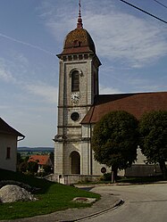
 The church in Loray | |
Location of Loray  | |
 Loray  Loray | |
| Coordinates: 47°09′14″N 6°29′47″E | |
| Country | France |
| Region | Bourgogne-Franche-Comté |
| Department | Doubs |
| Arrondissement | Pontarlier |
| Canton | Valdahon |
| Government | |
| • Mayor (2020–2026) | Claude Roussel |
| Area 1 | 14.39 km2 (5.56 sq mi) |
| Population | 564 |
| • Density | 39/km2 (100/sq mi) |
| Time zone | UTC+01:00 (CET) |
| • Summer (DST) | UTC+02:00 (CEST) |
| INSEE/Postal code | 25249 /25390 |
| Elevation | 500–971 m (1,640–3,186 ft) (avg. 745 m or 2,444 ft) |
| 1 French Land Register data, which excludes lakes, ponds, glaciers > 1 km2 (0.386 sq mi or 247 acres) and river estuaries. | |
Geography
Loray lies 12 km (7.5 mi) south of Pierrefontaine, near Valdahon and Orchamps-Vennes at approximately 50 km (31 mi) east of Besançon on the road between Morteau and Besançon. Its highest point is the Roche-Barchey at 1000 m.
Population
| Year | Pop. | ±% |
|---|---|---|
| 1841 | 508 | — |
| 1845 | 378 | −25.6% |
| 1849 | 567 | +50.0% |
| 1962 | 344 | −39.3% |
| 1968 | 356 | +3.5% |
| 1975 | 305 | −14.3% |
| 1982 | 365 | +19.7% |
| 1990 | 372 | +1.9% |
| 1999 | 404 | +8.6% |
| 2008 | 466 | +15.3% |
| 2012 | 489 | +4.9% |
Its inhabitants are called Loraitins (or Cabas).
Nearby communes
The neighbouring communes are La Sommette, Flangebouche, Orchamps-Vennes, Plaimbois-Vennes, and Vennes.
See also
References
- "Populations légales 2019". The National Institute of Statistics and Economic Studies. 29 December 2021.
External links
| Wikimedia Commons has media related to Loray. |
Текст в блоке "Читать" взят с сайта "Википедия" и доступен по лицензии Creative Commons Attribution-ShareAlike; в отдельных случаях могут действовать дополнительные условия.
Другой контент может иметь иную лицензию. Перед использованием материалов сайта WikiSort.org внимательно изучите правила лицензирования конкретных элементов наполнения сайта.
Другой контент может иметь иную лицензию. Перед использованием материалов сайта WikiSort.org внимательно изучите правила лицензирования конкретных элементов наполнения сайта.
2019-2025
WikiSort.org - проект по пересортировке и дополнению контента Википедии
WikiSort.org - проект по пересортировке и дополнению контента Википедии