world.wikisort.org - France
The arrondissement of Saint-Lô is an arrondissement of France in the Manche department in the Normandy region. It has 87 communes.[2] Its population is 103,045 (2016), and its area is 1,277.3 km2 (493.2 sq mi).[3]
Saint-Lô | |
|---|---|
Arrondissement | |
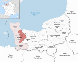 Location within the region Normandy | |
| Country | France |
| Region | Normandy |
| Department | Manche |
| No. of communes | 87 |
| Prefecture | Saint-Lô |
| Area | 1,277.3 km2 (493.2 sq mi) |
| Population | 103,054 |
| • Density | 81/km2 (210/sq mi) |
| INSEE code | 504 |
Composition
The communes of the arrondissement of Saint-Lô, and their INSEE codes, are:[2]
- Agneaux (50002)
- Airel (50004)
- Amigny (50006)
- Auvers (50023)
- La Barre-de-Semilly (50032)
- Baudre (50034)
- Beaucoudray (50039)
- Bérigny (50046)
- Beslon (50048)
- Beuvrigny (50050)
- Biéville (50054)
- La Bloutière (50060)
- Bourguenolles (50069)
- Bourgvallées (50546)
- Canisy (50095)
- Carantilly (50098)
- Carentan-les-Marais (50099)
- Cavigny (50106)
- Cerisy-la-Forêt (50110)
- Champrepus (50118)
- Chérencé-le-Héron (50130)
- La Colombe (50137)
- Condé-sur-Vire (50139)
- Couvains (50148)
- Dangy (50159)
- Le Dézert (50161)
- Domjean (50164)
- Fleury (50185)
- Fourneaux (50192)
- Gouvets (50214)
- Graignes-Mesnil-Angot (50216)
- Le Guislain (50225)
- La Haye-Bellefond (50234)
- Lamberville (50261)
- La Lande-d'Airou (50262)
- Le Lorey (50279)
- La Luzerne (50283)
- Margueray (50291)
- Marigny-le-Lozon (50292)
- Maupertuis (50295)
- La Meauffe (50297)
- Méautis (50298)
- Le Mesnil-Amey (50302)
- Le Mesnil-Eury (50310)
- Le Mesnil-Rouxelin (50321)
- Le Mesnil-Véneron (50324)
- Montabot (50334)
- Montbray (50338)
- Montrabot (50351)
- Montreuil-sur-Lozon (50352)
- Moon-sur-Elle (50356)
- Morigny (50357)
- Moyon-Villages (50363)
- Percy-en-Normandie (50393)
- Le Perron (50398)
- Pont-Hébert (50409)
- Quibou (50420)
- Rampan (50423)
- Remilly-les-Marais (50431)
- Saint-Amand-Villages (50444)
- Saint-André-de-Bohon (50445)
- Saint-André-de-l'Épine (50446)
- Saint-Clair-sur-l'Elle (50455)
- Sainte-Cécile (50453)
- Sainte-Suzanne-sur-Vire (50556)
- Saint-Fromond (50468)
- Saint-Georges-d'Elle (50473)
- Saint-Georges-Montcocq (50475)
- Saint-Germain-d'Elle (50476)
- Saint-Gilles (50483)
- Saint-Jean-de-Daye (50488)
- Saint-Jean-d'Elle (50492)
- Saint-Jean-de-Savigny (50491)
- Saint-Lô (50502)
- Saint-Louet-sur-Vire (50504)
- Saint-Martin-de-Bonfossé (50512)
- Saint-Pierre-de-Semilly (50538)
- Saint-Vigor-des-Monts (50563)
- Terre-et-Marais (50564)
- Tessy-Bocage (50592)
- Thèreval (50239)
- Torigny-les-Villes (50601)
- Tribehou (50606)
- La Trinité (50607)
- Villebaudon (50637)
- Villedieu-les-Poêles-Rouffigny (50639)
- Villiers-Fossard (50641)
History
The arrondissement of Saint-Lô was created in 1800.[4] At the January 2017 reorganisation of the arrondissements of Manche, it gained one commune from the arrondissement of Coutances, and it lost two communes to the arrondissement of Coutances.[5]
As a result of the reorganisation of the cantons of France which came into effect in 2015, the borders of the cantons are no longer related to the borders of the arrondissements. The cantons of the arrondissement of Saint-Lô were, as of January 2015:[6]
- Canisy
- Carentan
- Marigny
- Percy
- Saint-Clair-sur-l'Elle
- Saint-Jean-de-Daye
- Saint-Lô-Est
- Saint-Lô-Ouest
- Tessy-sur-Vire
- Torigni-sur-Vire
- Villedieu-les-Poêles
References
- "Téléchargement du fichier d'ensemble des populations légales en 2019". The National Institute of Statistics and Economic Studies. 29 December 2021.
- "Arrondissement de Saint-Lô (504)". INSEE. Retrieved 2019-10-01.
- "Comparateur de territoire, géographie au 01/01/2019". INSEE. Retrieved 2019-10-01.
- Historique de la Manche
- "Arrêté préfectoral, 20 December 2016" (PDF). pp. 27–40. Retrieved 2019-10-22.
- Populations légales 2012: 50 Manche, INSEE
На других языках
[de] Arrondissement Saint-Lô
Das Arrondissement Saint-Lô ist eine französische Verwaltungseinheit im Département Manche innerhalb der Region Normandie. Verwaltungssitz (Präfektur) ist Saint-Lô.- [en] Arrondissement of Saint-Lô
[ru] Сен-Ло (округ)
Сен-Ло (фр. Saint-Lô) — округ (фр. Arrondissement) во Франции, один из округов в регионе Нормандия. Департамент округа — Манш. Супрефектура — Сен-Ло. Население округа на 2018 год составляло 102 928 человек. Плотность населения составляет 80 чел./км². Площадь округа составляет 1291,02 км².Другой контент может иметь иную лицензию. Перед использованием материалов сайта WikiSort.org внимательно изучите правила лицензирования конкретных элементов наполнения сайта.
WikiSort.org - проект по пересортировке и дополнению контента Википедии