world.wikisort.org - France
The arrondissement of Belfort is an arrondissement in the Bourgogne-Franche-Comté region of France. It is the only arrondissement of the Territoire de Belfort department. It has 101 communes.[2] Its population is 144,089 (2016), and its area is 609.4 km2 (235.3 sq mi).[3]
Belfort | |
|---|---|
Arrondissement | |
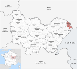 Location within the region Bourgogne-Franche-Comté | |
| Country | France |
| Region | Bourgogne-Franche-Comté |
| Department | Territoire de Belfort |
| No. of communes | 101 |
| Prefecture | Belfort |
| Area | 609.4 km2 (235.3 sq mi) |
| Population | 141,318 |
| • Density | 232/km2 (600/sq mi) |
| INSEE code | 901 |
Composition
The communes of the arrondissement of Belfort are:[2]
- Andelnans (90001)
- Angeot (90002)
- Anjoutey (90003)
- Argiésans (90004)
- Autrechêne (90082)
- Auxelles-Bas (90005)
- Auxelles-Haut (90006)
- Banvillars (90007)
- Bavilliers (90008)
- Beaucourt (90009)
- Belfort (90010)
- Bermont (90011)
- Bessoncourt (90012)
- Bethonvilliers (90013)
- Boron (90014)
- Botans (90015)
- Bourg-sous-Châtelet (90016)
- Bourogne (90017)
- Brebotte (90018)
- Bretagne (90019)
- Buc (90020)
- Charmois (90021)
- Châtenois-les-Forges (90022)
- Chaux (90023)
- Chavanatte (90024)
- Chavannes-les-Grands (90025)
- Chèvremont (90026)
- Courcelles (90027)
- Courtelevant (90028)
- Cravanche (90029)
- Croix (90030)
- Cunelières (90031)
- Danjoutin (90032)
- Delle (90033)
- Denney (90034)
- Dorans (90035)
- Eguenigue (90036)
- Éloie (90037)
- Essert (90039)
- Étueffont (90041)
- Évette-Salbert (90042)
- Faverois (90043)
- Fêche-l'Église (90045)
- Felon (90044)
- Florimont (90046)
- Fontaine (90047)
- Fontenelle (90048)
- Foussemagne (90049)
- Frais (90050)
- Froidefontaine (90051)
- Giromagny (90052)
- Grandvillars (90053)
- Grosmagny (90054)
- Grosne (90055)
- Joncherey (90056)
- Lachapelle-sous-Chaux (90057)
- Lachapelle-sous-Rougemont (90058)
- Lacollonge (90059)
- Lagrange (90060)
- Lamadeleine-Val-des-Anges (90061)
- Larivière (90062)
- Lebetain (90063)
- Lepuix (90065)
- Lepuix-Neuf (90064)
- Leval (90066)
- Menoncourt (90067)
- Meroux-Moval (90068)
- Méziré (90069)
- Montbouton (90070)
- Montreux-Château (90071)
- Morvillars (90072)
- Novillard (90074)
- Offemont (90075)
- Pérouse (90076)
- Petit-Croix (90077)
- Petitefontaine (90078)
- Petitmagny (90079)
- Phaffans (90080)
- Réchésy (90081)
- Recouvrance (90083)
- Reppe (90084)
- Riervescemont (90085)
- Romagny-sous-Rougemont (90086)
- Roppe (90087)
- Rougegoutte (90088)
- Rougemont-le-Château (90089)
- Saint-Dizier-l'Évêque (90090)
- Saint-Germain-le-Châtelet (90091)
- Sermamagny (90093)
- Sevenans (90094)
- Suarce (90095)
- Thiancourt (90096)
- Trévenans (90097)
- Urcerey (90098)
- Valdoie (90099)
- Vauthiermont (90100)
- Vellescot (90101)
- Vescemont (90102)
- Vétrigne (90103)
- Vézelois (90104)
- Villars-le-Sec (90105)
Demography
| Year | Pop. | ±% p.a. |
|---|---|---|
| 1968 | 118,450 | — |
| 1975 | 128,125 | +1.13% |
| 1982 | 131,999 | +0.43% |
| 1990 | 134,097 | +0.20% |
| 1999 | 137,408 | +0.27% |
| 2007 | 142,444 | +0.45% |
| 2012 | 143,940 | +0.21% |
| 2017 | 142,622 | −0.18% |
| Source: INSEE[4] | ||
History
The arrondissement of Belfort was created in 1800 as a part of the department Haut-Rhin.[5] This arrondissement was larger than the current one, and also included part that is now in the department Haut-Rhin, for instance the communes Cernay, Dannemarie, Masevaux, Saint-Amarin and Thann.[6] In 1871, when most of Haut-Rhin was ceded to Germany, the part remaining in France became the Territoire de Belfort.[7]
As a result of the reorganisation of the cantons of France which came into effect in 2015, the borders of the cantons are no longer related to the borders of the arrondissements. The cantons of the arrondissement of Belfort were, as of January 2015:[8]
- Beaucourt
- Belfort-Centre
- Belfort-Est
- Belfort-Nord
- Belfort-Ouest
- Belfort-Sud
- Châtenois-les-Forges
- Danjoutin
- Delle
- Fontaine
- Giromagny
- Grandvillars
- Offemont
- Rougemont-le-Château
- Valdoie
References
- "Téléchargement du fichier d'ensemble des populations légales en 2019". The National Institute of Statistics and Economic Studies. 29 December 2021.
- "Arrondissement de Belfort (901)". INSEE. Retrieved 2019-10-04.
- "Comparateur de territoire, géographie au 01/01/2019". INSEE. Retrieved 2019-10-04.
- Population en historique depuis 1968, INSEE
- Historique du Haut-Rhin
- Almanach Impérial pour l'an XIII (in French). Paris: Testu. 1805. p. 344. Retrieved 28 October 2019 – via Gallica.
- Historique du Territoire de Belfort
- "Populations légales 2012: 90 Territoire de Belfort" (PDF). INSEE. December 2014.
|
| Authority control |
|
|---|
На других языках
[de] Arrondissement Belfort
Das Arrondissement Belfort ist das einzige Arrondissement des französischen Départements Territoire de Belfort innerhalb der Region Bourgogne-Franche-Comté. Hauptort (Sitz der Präfektur) ist Belfort.- [en] Arrondissement of Belfort
[ru] Бельфор (округ)
Бельфор (фр. Belfort) — округ (фр. Arrondissement) во Франции, один из округов в регионе Франш-Конте. Департамент округа — Территория Бельфор. Супрефектура — Бельфор. Население округа на 2006 год составляло 141 201 человек. Плотность населения составляет 232 чел./км². Площадь округа составляет всего 609 км².Другой контент может иметь иную лицензию. Перед использованием материалов сайта WikiSort.org внимательно изучите правила лицензирования конкретных элементов наполнения сайта.
WikiSort.org - проект по пересортировке и дополнению контента Википедии