world.wikisort.org - France
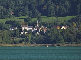
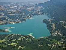
Aiguebelette-le-Lac (French pronunciation: [ɛɡbəlɛt lə lak]) is a commune and village in the Savoie department in the Auvergne-Rhône-Alpes region in south-eastern France. In 2016, it had a population of 249 people. It is named after and lies near the southeastern shore of Lac d'Aiguebelette, one of the largest natural lakes of France. Le Port is a small port on the lake, with a beach. The commune contains the Château d'Aiguebelette, a medieval structure which is in a ruinous state, while the main church in the area, dedicated to Saint Andrew, was restored in 1854.
Aiguebelette-le-Lac | |
|---|---|
Commune | |
 | |
 Coat of arms | |
Location of Aiguebelette-le-Lac  | |
 Aiguebelette-le-Lac  Aiguebelette-le-Lac | |
| Coordinates: 45°32′19″N 5°48′56″E | |
| Country | France |
| Region | Auvergne-Rhône-Alpes |
| Department | Savoie |
| Arrondissement | Chambéry |
| Canton | Le Pont-de-Beauvoisin |
| Intercommunality | Lac d'Aiguebelette |
| Government | |
| • Mayor (2020–2026) | Claude Coutaz[1] |
| Area 1 | 7.91 km2 (3.05 sq mi) |
| Population | 232 |
| • Density | 29/km2 (76/sq mi) |
| Demonym(s) | Aiguebelettois |
| Time zone | UTC+01:00 (CET) |
| • Summer (DST) | UTC+02:00 (CEST) |
| INSEE/Postal code | 73001 /73610 |
| Elevation | 372–1,360 m (1,220–4,462 ft) |
| 1 French Land Register data, which excludes lakes, ponds, glaciers > 1 km2 (0.386 sq mi or 247 acres) and river estuaries. | |
History
During the period of occupation of the Duchy of Savoy by the French revolutionary troops, following the annexation of 1792, the commune belonged to the canton of Le Pont-de-Beauvoisin, in the Mont Blanc Department.[3]
During the Second World War. Aiguebelette-le-Lac, located in an unoccupied zone, was the scene of a significant event with the house arrest of many foreign Jewish families living in hotels at the time. On August 26, 1942 these families underwent a roundup organized by the French police under the orders of the government of Vichy. Many of them were deported and murdered in Auschwitz.[4] The neighboring municipalities of Lépin-le-Lac and Saint-Alban-de-Montbel were also affected by this policy of regrouping foreign Jews to deport them.
Geography

The village of Aiguebelette-le-Lac lies near the southeastern shore of Lac d'Aiguebelette. There is a port and beach on the lake to the north of the town on the shore at Le Port. The commune contains the hamlets of Les Allamans, Les Cambet, La Combe, La Girardière, Le Noyau, Les Prés, Le Port, Les Gustin, Le Bourg, Le Boyat, Côte-Épine, Les Combettes, Le Cugnet, Les Culées, Le Fayet, Malacôte, Le Sauget and Le Platon.[5]
Landmarks

There are the remains of a fortified village in the vicinity, with the door to an old medieval enclosure. There are also prehistoric pile-dwelling (or stilt house) settlements that are part of the Prehistoric Pile dwellings around the Alps UNESCO World Heritage Site.[6] The Château d'Aiguebelette is in a ruinous state. In 1317 it was mentioned in an act passed by Dauphin.[7] The main church in the area is dedicated to Saint Andrew (Saint André). It was restored in 1854.[8]
Transport
The D9210 road passes through passes through Aiguebelette-le-Lac and skirts the eastern shore of the lake, leading to Autoroute A43. The commune is served by the railway station Gare d'Aiguebelette-le-Lac, on the TER Auvergne-Rhône-Alpes line. The nearest airport is at Chambéry Airport.[5]
See also
References
- "Répertoire national des élus: les maires". data.gouv.fr, Plateforme ouverte des données publiques françaises (in French). 2 December 2020.
- "Populations légales 2019". The National Institute of Statistics and Economic Studies. 29 December 2021.
- Vernier, Jules-Joseph, Étude historique et géographique sur la Savoie, Le Livre d'Histoire - Res Universis (repr. 1993) (1st ed. 1896), 137 p. (ISBN 2-7428-0039-5, ISSN 0993-7129), p. 96-99. (in French)
- Catherine Lewertowski (2003). Morts ou juifs: la maison de Moissac, 1939-1945 (in French). Flammarion. p. 172. ISBN 9782082103237.
- [Google (10 August 2019). "Aiguebelette-le-Lac" (Map). Google Maps. Google. Retrieved 10 August 2019.
- "UNESCO World Heritage Site - Prehistoric Pile dwellings around the Alps". UNESCO. Retrieved 10 August 2019.
- Pailard, Philippe, Histoire des communes savoyardes, Volume 1, Horvath, p.260
- Mémoires et documents, Volume 58 (in French). Société savoisienne d'histoire et d'archéologie. 1918. p. 175.
External links
![]() Media related to Aiguebelette-le-Lac at Wikimedia Commons
Media related to Aiguebelette-le-Lac at Wikimedia Commons
На других языках
- [en] Aiguebelette-le-Lac
[ru] Эгбелет-ле-Лак
Эгбелет-ле-Лак (фр. Aiguebelette-le-Lac) — коммуна во Франции, департамент Савойя, регион Овернь — Рона — Альпы. Входит в состав кантона Ле-Пон-де-Бовуазен, округ Шамбери[1]. На 2012 год население коммуны составляло 249 человек. На территории коммуны расположено одно из доисторических свайных поселений, внесённое во Всемирное наследие ЮНЕСКО[2].Другой контент может иметь иную лицензию. Перед использованием материалов сайта WikiSort.org внимательно изучите правила лицензирования конкретных элементов наполнения сайта.
WikiSort.org - проект по пересортировке и дополнению контента Википедии