world.wikisort.org - France
Aiglun (French pronunciation: [ɛɡlœ̃]) is a commune in the Alpes-Maritimes department in the Provence-Alpes-Côte d'Azur region of southeastern France.
Aiglun | |
|---|---|
Commune | |
 A general view of the village | |
 Coat of arms | |
Location of Aiglun  | |
 Aiglun  Aiglun | |
| Coordinates: 43°51′30″N 6°54′54″E | |
| Country | France |
| Region | Provence-Alpes-Côte d'Azur |
| Department | Alpes-Maritimes |
| Arrondissement | Grasse |
| Canton | Vence |
| Intercommunality | Alpes d'Azur |
| Government | |
| • Mayor (2020–2026) | Anthony Salomone[1] |
| Area 1 | 15.37 km2 (5.93 sq mi) |
| Population | 94 |
| • Density | 6.1/km2 (16/sq mi) |
| Time zone | UTC+01:00 (CET) |
| • Summer (DST) | UTC+02:00 (CEST) |
| INSEE/Postal code | 06001 /06910 |
| Elevation | 373–1,541 m (1,224–5,056 ft) (avg. 624 m or 2,047 ft) |
| 1 French Land Register data, which excludes lakes, ponds, glaciers > 1 km2 (0.386 sq mi or 247 acres) and river estuaries. | |
The inhabitants of the commune are known as Aiglenois or Aiglenoises.[3]
Geography
Aiglun is a remote mountain commune some 40 km north-east of Nice in a straight line. There are only two access routes to the commune - the first by Highway D17 from Roquesteron to the east. Heading west on Highway D17 continue left onto Highway D10 which continues via a mountainous route into the commune and the village of Aiglun. The other access is the continuation of Highway D10 west from Aiglun over a circuitous mountain route to Le Mas. The Estéron river passes through the commune south of the village and forms part of the western border of the commune as well as a small portion of the eastern border. Numerous streams feed into this river in the commune.
The northern part of the commune consists of high snow-capped mountains while the southern part is less high mountains. There are few roads however there are four hamlets in the Esteron Valley: Vascogne, Les Lones, Le Colombier, and L'Escle.[4]
Neighbouring communes and villages
Places adjacent to Aiglun, Alpes-Maritimes | ||||||||||||||||
|---|---|---|---|---|---|---|---|---|---|---|---|---|---|---|---|---|
| ||||||||||||||||
History
In 1388 the village of Aiglun was under the protection of the House of Savoy like the rest of the region during the "Dédition of Nice to Savoy"[5] from 1388.
At the Treaty of Turin on 24 March 1760, the commune became French (the kingdom of France and that of Sardinia then proceeded to boundary adjustments and therefore there was an exchange of territories).
Toponymy
The name of the town appears for the first time in texts around 1200 in the form Ayglezuni. This was derived from the Latin word Aquila, meaning "eagle", and the Gallic dunum, meaning "height" and signifies as a whole the "height of the eagle".[6]
Heraldry
 |
Blazon: Azure, a spread eagle of Argent over a salmon the same.
|
Administration
This list is incomplete; you can help by adding missing items. (April 2021) |
List of Successive Mayors of Aiglun[7]
| From | To | Name | Party | Position |
|---|---|---|---|---|
| 1870 | 1874 | Jean-Baptiste GRANIER | ||
| 1874 | 1876 | Antoine BERNARD | ||
| 1876 | 1878 | Louis BERNARD | ||
| 1878 | 1881 | Auguste BONNEFROI | ||
| 1881 | 1884 | Désiré MARTEL | ||
| 1884 | 1888 | Joseph DAUMAS | ||
| 1888 | 1896 | Désiré MARTEL | ||
| 1896 | 1900 | Jean-Pierre JAUME | ||
| 1900 | 1901 | Pierre GUIZOL | ||
| 1901 | 1912 | Joseph ROBIN | ||
| 1912 | 1920 | Jean-Pierre JAUME | ||
| 1920 | 1942 | Antoine ROUX |

- Mayors from 1942
| From | To | Name | Party |
|---|---|---|---|
| 1942 | 1945 | François Blanc | |
| 1945 | 1978 | Pierre Martin | |
| 1978 | 2001 | Marius Blanc | |
| 2001 | 2005 | Irene Montiglio | SE |
| 2005 | 2014 | Charles Bremond | DVD |
| 2014 | 2020 | Didier Nicolas | |
| 2020 | Current | Anthony Salomone |
Population
|
| ||||||||||||||||||||||||||||||||||||||||||||||||||||||||||||||||||||||||||||||||||||||||||||||||||||||||||||||||||
| Source: EHESS[8] and INSEE[9] | |||||||||||||||||||||||||||||||||||||||||||||||||||||||||||||||||||||||||||||||||||||||||||||||||||||||||||||||||||


Sites and Monuments
The village is known for its steep climbing walls over 200 metres high with high difficulty routes. The Aiglun canyon is also popular for canyoning enthusiasts.
Aiglun Picture Gallery
 The Village
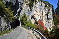 First tunnel on the road to the village
 The bridge entering Aiglun
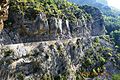 The cliff road into Aiglun
 An Oratory in the cliff face
 The entry to Aiglun
 Main entrance to Aiglun
 Aiglun Water Trough
 Aiglun Church


Notable people
- Fanny Robiane. Daughter of Joseph Robin, who was mayor of Aiglun in the early 20th century, this French theatre actress died in 1982 at Aiglun, where she retired and she has left a rich archive (autographed books, including by Armand Godoy, Jean-Richard Bloch and others; pictures; clippings, etc.). Her memory is still alive with the people of Aiglun (the Aiglenois) who knew her and plans are underway to honour her. A cultural association sponsored among others by the commune and the General Council launched since 2004 called "Fanny Robiane Encounter" devoted to theatre, poetry, music and other one-time cultural events are scheduled throughout the year. Sometimes these events are carried out in collaboration with the University of Nice.
See also
- Communes of the Alpes-Maritimes department
- Yves Bernard, The Tourist and Cultural Directory of the Alpes-Maritimes and Monaco, p. 149 Publishing Campanile, 1997 (ISBN 978-2-912366-00-9)
References
- "Répertoire national des élus: les maires". data.gouv.fr, Plateforme ouverte des données publiques françaises (in French). 2 December 2020.
- "Populations légales 2019". The National Institute of Statistics and Economic Studies. 29 December 2021.
- Inhabitants of Alpes-Maritimes (in French)
- Google Maps
- This was a charter of 28 September 1388 which attached Nice to the new territories of Provence for the House of Savoy. See Dédition de Nice à la Savoie in the French Wikipedia
- Ernest Nègre, Toponymie générale de la France: etymology of 35,000 place names, Genève: Librairie Droz, 1990. Collection of Roman and French Publications, volume 193. Volume I : Preceltic, Celtic, and Roman words, § 2725, p. 173,
- List of Mayors of France
- Des villages de Cassini aux communes d'aujourd'hui: Commune data sheet Aiglun, EHESS. (in French)
- Population en historique depuis 1968, INSEE
External links
- Official website for Aiglun (in French)
- Aiglun on the old IGN website (in French)
- Aiglun on Géoportail, National Geographic Institute (IGN) website (in French)
- Aiglun on the 1750 Cassini Map
На других языках
[de] Aiglun (Alpes-Maritimes)
Aiglun ist eine französische Gemeinde im Département Alpes-Maritimes in der Region Provence-Alpes-Côte d’Azur. Sie gehört zum Arrondissement Grasse und zum Kanton Vence.- [en] Aiglun, Alpes-Maritimes
[ru] Эглён (Приморские Альпы)
Эглён (фр. Aiglun) — коммуна на юго-востоке Франции в регионе Прованс — Альпы — Лазурный берег, департамент Приморские Альпы, округ Грас, кантон Ванс[1]. До марта 2015 года коммуна административно входила в состав упразднённого кантона Сент-Обан (округ Грас).Другой контент может иметь иную лицензию. Перед использованием материалов сайта WikiSort.org внимательно изучите правила лицензирования конкретных элементов наполнения сайта.
WikiSort.org - проект по пересортировке и дополнению контента Википедии