world.wikisort.org - Frankreich
La Mancelière ist eine französische Gemeinde mit 178 Einwohnern (Stand: 1. Januar 2019) im Département Eure-et-Loir in der Region Centre-Val de Loire; sie gehört zum Arrondissement Dreux und ist Teil des Kantons Saint-Lubin-des-Joncherets (bis 2015: Kanton Brezolles).
| La Mancelière | ||
|---|---|---|
| Staat | Frankreich | |
| Region | Centre-Val de Loire | |
| Département (Nr.) | Eure-et-Loir (28) | |
| Arrondissement | Dreux | |
| Kanton | Saint-Lubin-des-Joncherets | |
| Gemeindeverband | Agglo du Pays de Dreux | |
| Koordinaten | 48° 39′ N, 1° 0′ O | |
| Höhe | 179–212 m | |
| Fläche | 5,9 km² | |
| Einwohner | 178 (1. Januar 2019) | |
| Bevölkerungsdichte | 30 Einw./km² | |
| Postleitzahl | 28270 | |
| INSEE-Code | 28231 | |
 Mairie La Mancelière | ||
Geographie
La Mancelière liegt etwa 45 Kilometer nordwestlich von Chartres. Umgeben wird La Mancelière von den Nachbargemeinden Beauche im Norden, Les Châtelets im Osten und Nordosten, La Saucelle im Osten und Südosten, La Puisaye im Süden sowie Morvilliers im Westen.
Bevölkerungsentwicklung
| Jahr | 1962 | 1968 | 1975 | 1982 | 1990 | 1999 | 2006 | 2017 |
|---|---|---|---|---|---|---|---|---|
| Einwohner | 148 | 127 | 102 | 117 | 134 | 142 | 158 | 187 |
| Quellen: Cassini und INSEE | ||||||||
Sehenswürdigkeiten
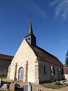
- Kirche Notre-Dame

Weblinks
Commons: La Mancelière – Sammlung von Bildern, Videos und Audiodateien
На других языках
- [de] La Mancelière
[en] La Mancelière
La Mancelière (French pronunciation: [la mɑ̃s(ə)ljɛʁ]) is a commune in the Eure-et-Loir department and Centre-Val de Loire region of north-central France. It lies 44 km north-west of Chartres, 30 km west-south-west of Dreux, and some 105 km from Paris.Текст в блоке "Читать" взят с сайта "Википедия" и доступен по лицензии Creative Commons Attribution-ShareAlike; в отдельных случаях могут действовать дополнительные условия.
Другой контент может иметь иную лицензию. Перед использованием материалов сайта WikiSort.org внимательно изучите правила лицензирования конкретных элементов наполнения сайта.
Другой контент может иметь иную лицензию. Перед использованием материалов сайта WikiSort.org внимательно изучите правила лицензирования конкретных элементов наполнения сайта.
2019-2025
WikiSort.org - проект по пересортировке и дополнению контента Википедии
WikiSort.org - проект по пересортировке и дополнению контента Википедии
