world.wikisort.org - Frankreich
Bosroumois ist eine französische Gemeinde mit 3.649 Einwohnern (Stand: 1. Januar 2019) im Département Eure in der Region Normandie. Sie gehört zum Arrondissement Bernay sowie zum Kanton Grand Bourgtheroulde und ist Mitglied im Gemeindeverband Roumois Seine.
| Bosroumois | ||
|---|---|---|
| ||
| Staat | Frankreich | |
| Region | Normandie | |
| Département (Nr.) | Eure (27) | |
| Arrondissement | Bernay | |
| Kanton | Grand Bourgtheroulde | |
| Gemeindeverband | Roumois Seine | |
| Koordinaten | 49° 17′ N, 0° 56′ O | |
| Höhe | 107–162 m | |
| Fläche | 13,24 km² | |
| Einwohner | 3.649 (1. Januar 2019) | |
| Bevölkerungsdichte | 276 Einw./km² | |
| Postleitzahl | 27670 | |
| INSEE-Code | 27090 | |

Geografie
Bosroumois liegt etwa 30 Kilometer südsüdwestlich von Rouen. Umgeben wird Bosroumois von den Nachbargemeinden La Londe im Norden, Saint-Ouen-du-Tilleul im Osten, Le Thuit de l’Oison im Süden, Saint-Pierre-de-Bosguérard im Süden und Südwesten sowie Grand Bourgtheroulde im Westen.
Geschichte
Zum 1. Januar 2017 wurden die bis dahin eigenständigen Kommunen Le Bosc-Roger-en-Roumois und Bosnormand zur neuen Gemeinde (commune nouvelle) Bosroumois zusammengeschlossen. Der Sitz dieser neu geschaffenen Gebietskörperschaft befindet sich im Ortsteil Le Bosc-Roger-en-Roumois.
Gliederung
| Ortsteil | ehemaliger INSEE-Code | Fläche (km²) | Höhenlage (m) | Einwohnerzahl (2019)[1] | Dichte (Einw. je km²) |
|---|---|---|---|---|---|
| Le Bosc-Roger-en-Roumois (Verwaltungssitz) | 27090 | 9,90 | 107–162 | 3.323 | 327,0 |
| Bosnormand | 27093 | 3,34 | 124–161 | 326 | 98,2 |
Sehenswürdigkeiten
Le Bosc-Roger-en-Roumois
- Kirche Saint-Pierre
Bosnormand
- Kirche Saint-Aubin aus dem 17. Jahrhundert
- Schloss Amfreville aus dem 17. Jahrhundert
 Kirche Saint-Pierre
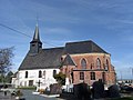 Kirche Saint-Aubin


Weblinks
Einzelnachweise
- Französisches Statistikinstitut (www.insee.fr)
На других языках
- [de] Bosroumois
[en] Bosroumois
Bosroumois (French pronunciation: [boʁumwa]) is a commune in the department of Eure, northern France. The municipality was established on 1 January 2017 by merger of the former communes of Le Bosc-Roger-en-Roumois (the seat) and Bosnormand.[2][ru] Борумуа
Борумуа (фр. Bosroumois) — новая коммуна на севере Франции, регион Нормандия, департамент Эр, округ Берне, кантон Гран-Буртерульд. Расположена в 27 км к юго-западу от Руана и в 46 км к северо-западу от Эврё, в 10 км от автомагистралей А13 «Нормандия» и А28.Другой контент может иметь иную лицензию. Перед использованием материалов сайта WikiSort.org внимательно изучите правила лицензирования конкретных элементов наполнения сайта.
WikiSort.org - проект по пересортировке и дополнению контента Википедии