 A grain processing facility by the Turku–Uusikaupunki railway in Nousiainen
 European route E8 in Nousiainen
 A kiosk at the Rantapiha recreational area by the Lake Savojärvi near Kurjenrahka National Park
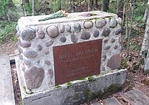 The memorial of Ahti Jalonen (1901–1918), a young victim of the White Terror during the Finnish Civil War
 Emovaha glacial erratic in Nousiainen
world.wikisort.org - Finland
Nousiainen (Finnish: [ˈnou̯siˌɑi̯nen]; Swedish: Nousis) is a municipality of Finland. It is located in the Southwest Finland region, 20 kilometres (12 mi) from Turku along Highway 8 (E8).[6] The Finnish-speaking municipality has a population of 4,688 (31 December 2021)[2] and covers an area of 199.55 square kilometres (77.05 sq mi) of which 0.62 km2 (0.24 sq mi) is water.[1] The population density is 23.58 inhabitants per square kilometre (61.1/sq mi).
Nousiainen
Nousis | |
|---|---|
Municipality | |
| Nousiaisten kunta Nousis kommun | |
 Nousiainen Church | |
 Coat of arms | |
 Location of Nousiainen in Finland | |
| Coordinates: 60°36′N 022°05′E | |
| Country | |
| Region | Southwest Finland |
| Sub-region | Turku sub-region |
| Charter | 1867 |
| Government | |
| • Municipal manager | Juhani Kylämäkilä |
| Area (2018-01-01)[1] | |
| • Total | 199.55 km2 (77.05 sq mi) |
| • Land | 198.81 km2 (76.76 sq mi) |
| • Water | 0.62 km2 (0.24 sq mi) |
| • Rank | 263rd largest in Finland |
| Population (2021-12-31)[2] | |
| • Total | 4,688 |
| • Rank | 178th largest in Finland |
| • Density | 23.58/km2 (61.1/sq mi) |
| Population by native language | |
| • Finnish | 98.3% (official) |
| • Swedish | 0.8% |
| • Others | 0.8% |
| Population by age | |
| • 0 to 14 | 19% |
| • 15 to 64 | 60.3% |
| • 65 or older | 20.6% |
| Time zone | UTC+02:00 (EET) |
| • Summer (DST) | UTC+03:00 (EEST) |
| Municipal tax rate[5] | 21.5% |
| Climate | Dfb |
| Website | www.nousiainen.fi |
There are two Natura 2000 sites in Nousiainen: the Kurjenrahka National Park and the Rehtisuo Raised Bog.[7]
History
Nousiainen was an "ancient parish" (a unit of social organization) before Swedish rule.
Nousiainen was the first seat of the bishop of Finland until the early 13th century, when the seat was shifted to Koroinen, nowadays a part of Turku. It remained, however, a place of pilgrimage throughout the Middle Ages.[8] The coat of arms of Nousiainen depicts Bishop Henry and Lalli.
Nousiainen was mentioned in 1232 as de Nousia and in 1234 as Nosis. Its name is derived from a pre-Christian Finnish personal name Nousia, still the name of some 10-20 men in 2022.[9] Even after the bishopric was moved to Koroinen, Nousiainen was still an important pilgrimage site until the reformation, as it was thought that bishop Henry was buried there.
The village of Nummi, the current administrative seat of the municipality, was mentioned in 1380 as Nummusby. Court sessions for Nousiainen, Masku and Santamala were held there at the time. By 1556, Nummi was the largest village in Nousiainen.[10]
Economics
Agriculture has always been Nousiainen's most significant industry. Significant employers also included Teleste Oyj's electronics factory, which, however, has already closed down in the municipality. In 2015, the municipality had 1,009 jobs; of these, 11% were in primary production (agriculture, forestry and fishery), 72% in services and 15% in processing.[11] The companies that paid the most corporate tax in 2016 were FCR Finland, which operates in the shipbuilding industry, Mynämäen-Nousiaisten Osuuspankki and Maalausliike Helin.[12]
Culture
Food
Sweetened potato casserole, or imelet perunloora in the local dialect, was named the traditional parish dish of Nousiainen in the 1980s.[13]
Notable people
- Mikko Rantanen (born 1996), professional ice hockey player for the Colorado Avalanche of the National Hockey League (NHL)
Gallery


See also
References
- "Area of Finnish Municipalities 1.1.2018" (PDF). National Land Survey of Finland. Retrieved 30 January 2018.
- "Preliminary population structure by area, 2021M01*-2021M12*". StatFin (in Finnish). Statistics Finland. Retrieved 2 February 2022.
- "Population according to language and the number of foreigners and land area km2 by area as of 31 December 2008". Statistics Finland's PX-Web databases. Statistics Finland. Retrieved 29 March 2009.
- "Population according to age (1-year) and sex by area and the regional division of each statistical reference year, 2003–2020". StatFin. Statistics Finland. Retrieved 2 May 2021.
- "List of municipal and parish tax rates in 2021" (PDF). Tax Administration of Finland. 1 December 2020. Retrieved 10 April 2021.
- Opaskartta - Turun karttapalvelu
- Natura 2000 -alueet - Varsinais-Suomi - Ympäristö (in Finnish)
- David Kirby, A Concise History of Finland (Cambridge, 2006), p. 7.
- "Digi- ja väestötietovirasto". verkkopalvelu.vrk.fi (in Finnish). August 15, 2022. Retrieved August 20, 2022.
{{cite web}}: CS1 maint: url-status (link) - "SuomalainenPaikannimikirja_e-kirja_kuvallinen.pdf" (PDF). kaino.kotus.fi (in Finnish). p. 293+294. Retrieved August 19, 2022.
{{cite web}}: CS1 maint: url-status (link) - Kuntien avainluvut - Statistics Finland (in Finnish)
- YLE: Alueen Nousiainen yhteisöverotiedot (in Finnish)
- Jaakko Kolmonen: Kotomaamme ruoka-aitta: Suomen, Karjalan ja Petsamon pitäjäruoat, p. 26. Helsinki: Patakolmonen Ky, 1988. (in Finnish)
External links
 Media related to Nousiainen at Wikimedia Commons
- Municipality of Nousiainen – Official website
Municipalities of Southwest Finland | ||
|---|---|---|
| Municipalities |  | |
| Former municipalities |
| |
| ||
На других языках
[de] Nousiainen
Nousiainen [.mw-parser-output .IPA a{text-decoration:none}ˈnɔu̯siɑi̯nɛn] (schwed. Nousis) ist eine Gemeinde im Südwesten Finnlands. Nousiainen liegt in der Landschaft Varsinais-Suomi rund 20 km nordwestlich von Turku. Viele der 4693 Einwohner (Stand 31. Dezember 2020) arbeiten in der nahegelegenen Großstadt. Seinen Namen (vom finnischen Wort für „heben“) erhielt der Ort wegen der starken Landhebung, die in Südwestfinnland 1 cm pro Jahr beträgt. Früher gehörte Nousiainen zum vorgelagerten Schärengebiet, durch die Landhebung wurde es zu einem Teil des Festlandes.- [en] Nousiainen
[ru] Ноусиайнен (община)
Ноусиайнен (фин. Nousiainen, швед. Nousis) — община в провинции Исконная Финляндия, губерния Западная Финляндия, Финляндия. Общая площадь территории — 199,43 км², из которых 0,62 км² — вода.Текст в блоке "Читать" взят с сайта "Википедия" и доступен по лицензии Creative Commons Attribution-ShareAlike; в отдельных случаях могут действовать дополнительные условия.
Другой контент может иметь иную лицензию. Перед использованием материалов сайта WikiSort.org внимательно изучите правила лицензирования конкретных элементов наполнения сайта.
Другой контент может иметь иную лицензию. Перед использованием материалов сайта WikiSort.org внимательно изучите правила лицензирования конкретных элементов наполнения сайта.
2019-2026
WikiSort.org - проект по пересортировке и дополнению контента Википедии
WikiSort.org - проект по пересортировке и дополнению контента Википедии