world.wikisort.org - Estonia
Jõhvi is a town in northeastern Estonia, and the administrative centre of the Ida-Viru County. The town is also an administrative centre of Jõhvi Parish. It is situated about 50 km west of the Estonia–Russia international border.
Jõhvi | |
|---|---|
Town | |
 | |
 Jõhvi Location in Estonia | |
| Coordinates: 59°21′27″N 27°25′37″E | |
| Country | Estonia |
| County | Ida-Viru County |
| Municipality | Jõhvi Parish |
| City status | 1938 |
| Area | |
| • Total | 7.62 km2 (2.94 sq mi) |
| Population (2021)[1] | |
| • Total | 10,130 |
| • Rank | 13th |
| • Density | 1,300/km2 (3,400/sq mi) |
| Ethnicity | |
| • Estonians | 34.5% |
| • Russians | 55.7% |
| • other | 9.6% |
| Time zone | UTC+2 (EET) |
| • Summer (DST) | UTC+3 (EEST) |
| Postal code | 41501 to 41599 |
| Area code | (+372) 33 |
History
Jõhvi was first mentioned as a village in 1241 in Liber Census Daniae when it was ruled by Denmark. Historical names of Jõhvi were Gewi and Jewe. In the 13th century a church was built there and Jõhvi became the centre of the local church parish.
On 1 May 1938, the government of Estonia upgraded the official status of Jõhvi from "borough" to that of an independent "town". During the period of Soviet occupation (1944–1991), Jõhvi was administratively not a town, but a district of the city of Kohtla-Järve. In 2005, the town of Jõhvi was united with the parish of Jõhvi.
During the period of the Soviet occupation, large numbers of immigrant workers from Russia and other parts of the former USSR were brought in to populate the rapidly growing city of Kohtla-Järve, including the then district of Jõhvi.[2][3] The population in the Jõhvi area which had been, as of 1934 census, over 90% ethnic Estonian, became overwhelmingly non-Estonian in the second half of the 20th century.[2] According to more recent data, about 55% of the town's population are ethnic Russians.
Population
Jõhvi population by year
- the year 1917. 1,300 people
- on April 1, 1938. 2525 people
- on January 1, 1999 12,922 ;
- the year 2000. 12,112 people of whom 6,482 (53.5%) were Russians and 4,022 (33.2%) Estonians;
- the year 2003. 11,743 people
- the year 2005. 11,533 people
- According to the 2011 census, 10,775 people of whom 3,718 (34.5%) are Estonians. [4]
Climate
| Climate data for Jõhvi (normals 1991–2020, extremes 1926–present) | |||||||||||||
|---|---|---|---|---|---|---|---|---|---|---|---|---|---|
| Month | Jan | Feb | Mar | Apr | May | Jun | Jul | Aug | Sep | Oct | Nov | Dec | Year |
| Record high °C (°F) | 8.9 (48.0) |
8.1 (46.6) |
16.8 (62.2) |
26.0 (78.8) |
32.1 (89.8) |
33.1 (91.6) |
33.7 (92.7) |
34.6 (94.3) |
28.1 (82.6) |
19.7 (67.5) |
13.6 (56.5) |
10.9 (51.6) |
34.6 (94.3) |
| Average high °C (°F) | −2.3 (27.9) |
−2.4 (27.7) |
1.9 (35.4) |
9.5 (49.1) |
15.8 (60.4) |
19.6 (67.3) |
22.4 (72.3) |
21.0 (69.8) |
15.7 (60.3) |
8.5 (47.3) |
2.7 (36.9) |
−0.5 (31.1) |
9.3 (48.7) |
| Daily mean °C (°F) | −4.6 (23.7) |
−5.2 (22.6) |
−1.7 (28.9) |
4.5 (40.1) |
10.3 (50.5) |
14.6 (58.3) |
17.4 (63.3) |
15.9 (60.6) |
11.2 (52.2) |
5.5 (41.9) |
0.6 (33.1) |
−2.5 (27.5) |
5.5 (41.9) |
| Average low °C (°F) | −7.5 (18.5) |
−8.5 (16.7) |
−5.5 (22.1) |
−0.1 (31.8) |
4.3 (39.7) |
9.1 (48.4) |
11.9 (53.4) |
10.9 (51.6) |
7.0 (44.6) |
2.4 (36.3) |
−1.7 (28.9) |
−5 (23) |
1.4 (34.5) |
| Record low °C (°F) | −34.5 (−30.1) |
−36 (−33) |
−28.4 (−19.1) |
−18 (0) |
−6.5 (20.3) |
−2.5 (27.5) |
1.7 (35.1) |
−0.6 (30.9) |
−4.2 (24.4) |
−15.7 (3.7) |
−25.9 (−14.6) |
−41 (−42) |
−41 (−42) |
| Average precipitation mm (inches) | 45 (1.8) |
34 (1.3) |
36 (1.4) |
34 (1.3) |
50 (2.0) |
84 (3.3) |
77 (3.0) |
93 (3.7) |
67 (2.6) |
84 (3.3) |
64 (2.5) |
49 (1.9) |
717 (28.2) |
| Average precipitation days (≥ 1.0 mm) | 12 | 9 | 9 | 8 | 7 | 10 | 11 | 12 | 13 | 14 | 14 | 14 | 132 |
| Average relative humidity (%) | 90 | 88 | 80 | 72 | 68 | 73 | 76 | 80 | 84 | 87 | 90 | 91 | 82 |
| Source: Estonian Weather Service (precipitation days, 1971–2000)[5][6][7][8][9] | |||||||||||||
Gallery
 Jõhvi church
 Central square
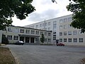 Jõhvi Gymnasium
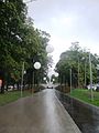 Jõhvi promenade
 Jõhvi Concert Hall
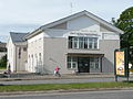 Jõhvi Central Library
 Jõhvi at night
 Monument in memoriam of Kaljo Kiisk


References
- "Population by sex, age group and place of residence after the 2017 administrative reform, 1 January". Statistics Estonia. Retrieved 2021-12-26.
- Duncan, W. Raymond (2019). Ethnic Nationalism And Regional Conflict: The Former Soviet Union And Yugoslavia. Routledge. ISBN 9780429715938.
- Kattago, Siobhan (2008). "Commemorating Liberation and Occupation: War Memorials Along the Road to Narva". Journal of Baltic Studies. 39 (4): 431–449. doi:10.1080/01629770802461225. S2CID 145001694.
- Eestlaste arv ja osatähtsus elukoha (asula) järgi, 31. detsember 2011
- "Climate normals-Temperature". Estonian Weather Service. Retrieved 14 February 2021.
- "Climate normals-Precipitation". Estonian Weather Service. Retrieved 14 February 2021.
- "Climate normals-Humidity". Estonian Weather Service. Retrieved 14 February 2021.
- "Kliimanormid-Sademed, õhuniiskus" (in Estonian). Estonian Weather Service. Archived from the original on 22 February 2012. Retrieved 14 February 2021.
- "Rekordid" (in Estonian). Estonian Weather Service. Retrieved 19 March 2021.
External links
Cities and towns of Estonia | ||
|---|---|---|
| ||
Jaanilinn (Ivangorod) and Petseri (Pechory) were annexed by the Soviet Union in 1945 and are currently part of Russia. | ||
Settlements in Jõhvi Parish | ||
|---|---|---|
| Town |  | |
| Small borough | ||
| Villages | ||
Authority control | |
|---|---|
| General |
|
| National libraries | |
| Other |
|
На других языках
[de] Jõhvi (Jõhvi)
Jõhvi (deutsch Jewe, russisch Йыхви) ist eine Stadt im Nordosten Estlands. Sie ist die Hauptstadt des Landkreises Ida-Viru.- [en] Jõhvi
[ru] Йыхви
Йы́хви (эст. Jõhvi) — город на северо-востоке Эстонии. С 1938 по 1940 год имел статус города в Эстонской Республике, затем с 1940 по 1991 год был в составе Эстонской ССР, в период с 1941 по 1944 год Йыхви находился под немецкой оккупацией. В настоящее время является административным центром уезда Ида-Вирумаа и волости Йыхви.Другой контент может иметь иную лицензию. Перед использованием материалов сайта WikiSort.org внимательно изучите правила лицензирования конкретных элементов наполнения сайта.
WikiSort.org - проект по пересортировке и дополнению контента Википедии