world.wikisort.org - Czech
Moravany (German: Morbes) is a municipality and village in Brno-Country District in the South Moravian Region of the Czech Republic. It has about 3,400 inhabitants.
Moravany | |
|---|---|
Municipality | |
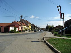
 Main road of Moravany | |
 Moravany Location in the Czech Republic | |
| Coordinates: 49°8′44″N 16°34′34″E | |
| Country | |
| Region | South Moravian |
| District | Brno-Country |
| First mentioned | 1289 |
| Area | |
| • Total | 6.64 km2 (2.56 sq mi) |
| Elevation | 246 m (807 ft) |
| Population (2022-01-01)[1] | |
| • Total | 3,382 |
| • Density | 510/km2 (1,300/sq mi) |
| Time zone | UTC+1 (CET) |
| • Summer (DST) | UTC+2 (CEST) |
| Postal code | 664 48 |
| Website | www |
Moravany lies approximately 7 kilometres (4 mi) south-west of Brno and 188 km (117 mi) south-east of Prague.
History
The first written mention of Moravany is from 1289.[2]
References
- "Population of Municipalities – 1 January 2022". Czech Statistical Office. 2022-04-29.
- "Historie" (in Czech). Obec Moravany. Retrieved 2021-11-18.
| Wikimedia Commons has media related to Moravany (Brno-Country District). |
Текст в блоке "Читать" взят с сайта "Википедия" и доступен по лицензии Creative Commons Attribution-ShareAlike; в отдельных случаях могут действовать дополнительные условия.
Другой контент может иметь иную лицензию. Перед использованием материалов сайта WikiSort.org внимательно изучите правила лицензирования конкретных элементов наполнения сайта.
Другой контент может иметь иную лицензию. Перед использованием материалов сайта WikiSort.org внимательно изучите правила лицензирования конкретных элементов наполнения сайта.
2019-2025
WikiSort.org - проект по пересортировке и дополнению контента Википедии
WikiSort.org - проект по пересортировке и дополнению контента Википедии
