world.wikisort.org - Czech
Kšice (German: Kscheutz) is a municipality and village in Tachov District in the Plzeň Region of the Czech Republic. It has about 200 inhabitants.
Kšice | |
|---|---|
Municipality | |
 Common pond | |
 Flag  Coat of arms | |
 Kšice Location in the Czech Republic | |
| Coordinates: 49°48′9″N 12°59′50″E | |
| Country | |
| Region | Plzeň |
| District | Tachov |
| First mentioned | 1369 |
| Area | |
| • Total | 15.44 km2 (5.96 sq mi) |
| Elevation | 488 m (1,601 ft) |
| Population (2022-01-01)[1] | |
| • Total | 226 |
| • Density | 15/km2 (38/sq mi) |
| Time zone | UTC+1 (CET) |
| • Summer (DST) | UTC+2 (CEST) |
| Postal code | 349 01 |
| Website | www |
Administrative parts
The village of Lomnička is an administrative part of Kšice.
Geography
Kšice is located about 25 kilometres (16 mi) east of Tachov and 27 km (17 mi) west of Plzeň. It lies in the Plasy Uplands. The highest point is the hill Stelka at 547 m (1,795 ft) above sea level.
History
The first written mention of Kšice is from 1369. It was then part of the Stříbro estate. Silver and lead were mined in the vicinity of the village. At the end of the 19th century, the last mine was closed down.[2]
After the Munich Agreement in 1938, the village was annexed by Nazi Germany and administered as part of Reichsgau Sudetenland.
In 1971, Lomnička was joined to the municipality. From 1980 to 1991, Kšice was an administrative part of Stříbro. Since 1992, it has been a separate municipality.[3]
Sights
The Church of the Assumption of the Virgin Mary is the landmark of Kšice. A predecessor of the church was a Gothic building, first documented in 1384. The current church was built in the Baroque style in 1716.[4]
Gallery
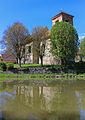 Church of the Assumption of the Virgin Mary
 Houses in the centre of Kšice
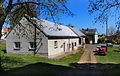 Municipal office


References
- "Population of Municipalities – 1 January 2022". Czech Statistical Office. 2022-04-29.
- "Historie" (in Czech). Obec Kšice. Retrieved 2022-09-21.
- "Historický lexikon obcí České republiky 1869–2011" (in Czech). Czech Statistical Office. 2015-12-21. pp. 265, 302.
- "Kostel Nanebevzetí Panny Marie" (in Czech). National Heritage Institute. Retrieved 2022-09-21.
External links
| Authority control: National libraries |
|---|
Другой контент может иметь иную лицензию. Перед использованием материалов сайта WikiSort.org внимательно изучите правила лицензирования конкретных элементов наполнения сайта.
WikiSort.org - проект по пересортировке и дополнению контента Википедии