world.wikisort.org - Czech
Kynšperk nad Ohří (Czech pronunciation: [ˈkɪnʃpɛrk ˈnat oɦr̝iː]; German: Königsberg an der Eger) is a town in Sokolov District in the Karlovy Vary Region of the Czech Republic. It has about 4,600 inhabitants.
Kynšperk nad Ohří | |
|---|---|
Town | |
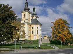
 Church of the Assumption of the Virgin Mary | |
 Flag  Coat of arms | |
 Kynšperk nad Ohří Location in the Czech Republic | |
| Coordinates: 50°7′8″N 12°31′59″E | |
| Country | |
| Region | Karlovy Vary |
| District | Sokolov |
| Founded | 1232 |
| Government | |
| • Mayor | Tomáš Svoboda (ČSSD) |
| Area | |
| • Total | 23.31 km2 (9.00 sq mi) |
| Elevation | 431 m (1,414 ft) |
| Population (2022-01-01)[1] | |
| • Total | 4,590 |
| • Density | 200/km2 (510/sq mi) |
| Time zone | UTC+1 (CET) |
| • Summer (DST) | UTC+2 (CEST) |
| Postal codes | 357 51, 358 01 |
| Website | www |
Administrative parts
Villages of Chotíkov, Dolní Pochlovice, Dvorečky, Kamenný Dvůr, Liboc, Štědrá and Zlatá are administrative parts of Kynšperk nad Ohří.
Geography
Kynšperk nad Ohří is located about 10 kilometres (6 mi) southwest of Sokolov and 28 km (17 mi) southwest of Karlovy Vary. It is situated mostly in the Cheb Basin. The southeastern part of the municipal territory extends into the Slavkov Forest and includes the highest point of Kynšperk nad Ohří, which is a contour line at 580 metres (1,900 ft) above sea level.
Kynšperk nad Ohří lies on the Ohře River. North of the town is located Boží požehnání Lake, an artificial lake created during the revitalization of a former lignite mine.
History
The town was founded in 1232. The town's founding charter is the oldest preserved document of establishing a locality in the Czech Republic and is stored in the National Archives in Prague.[2]
Transport
The D6 motorway runs next to the town.
Notable people
- Caspar Buberl (1834–1899), American sculptor
- Alfred Scharf (1900–1965), British art historian
Twin towns – sister cities
Kynšperk nad Ohří is twinned with:[3]
 Himmelkron, Germany
References
- "Population of Municipalities – 1 January 2022". Czech Statistical Office. 2022-04-29.
- "Zakládací listina" (in Czech). Město Kynšperk nad Ohří. Retrieved 2020-07-27.
- "Partnerské město Himmelkron" (in Czech). Město Kynšperk nad Ohří. Retrieved 2020-07-24.
External links
- Official website (in Czech)
Другой контент может иметь иную лицензию. Перед использованием материалов сайта WikiSort.org внимательно изучите правила лицензирования конкретных элементов наполнения сайта.
WikiSort.org - проект по пересортировке и дополнению контента Википедии