world.wikisort.org - Czech
Horoměřice is a municipality and village in Prague-West District in the Central Bohemian Region of the Czech Republic. It has about 4,500 inhabitants.
Horoměřice | |
|---|---|
Municipality | |
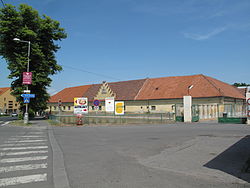
 Horoměřice Castle | |
 Flag  Coat of arms | |
 Horoměřice Location in the Czech Republic | |
| Coordinates: 50°7′54″N 14°20′20″E | |
| Country | |
| Region | Central Bohemian |
| District | Prague-West |
| First mentioned | 1088 |
| Government | |
| • Mayor | Jan Herčík |
| Area | |
| • Total | 8.05 km2 (3.11 sq mi) |
| Elevation | 308 m (1,010 ft) |
| Population (2022-01-01)[1] | |
| • Total | 4,511 |
| • Density | 560/km2 (1,500/sq mi) |
| Time zone | UTC+1 (CET) |
| • Summer (DST) | UTC+2 (CEST) |
| Postal code | 252 62 |
| Website | www |
Geography
Horoměřice Jesenice is situated northwest of Prague, in its immediate vicinity. It lies in an agricultural landscape of the Prague Plateau.
History
The first written mention of Horoměřice is from 1273. Back then it was owned by the Strahov Monastery.[2]
Sights
There is a simple castle from the 18th century, which belonged to Strahov Monastery until 1945. Today it is owned by the municipality, which intends to reconstruct and use it for social and cultural purposes.[3]
Notable people
- Benedikt Roezl (1824–1885), traveller, gardener and botanist
References
- "Population of Municipalities – 1 January 2022". Czech Statistical Office. 2022-04-29.
- "Historie" (in Czech). Obec Horoměřice. Retrieved 2020-11-14.
- "Horoměřice chtějí opravit svůj zámek" (in Czech). Praha TV. 2019-07-12. Retrieved 2022-05-16.
External links
Wikimedia Commons has media related to Horoměřice.
Текст в блоке "Читать" взят с сайта "Википедия" и доступен по лицензии Creative Commons Attribution-ShareAlike; в отдельных случаях могут действовать дополнительные условия.
Другой контент может иметь иную лицензию. Перед использованием материалов сайта WikiSort.org внимательно изучите правила лицензирования конкретных элементов наполнения сайта.
Другой контент может иметь иную лицензию. Перед использованием материалов сайта WikiSort.org внимательно изучите правила лицензирования конкретных элементов наполнения сайта.
2019-2025
WikiSort.org - проект по пересортировке и дополнению контента Википедии
WikiSort.org - проект по пересортировке и дополнению контента Википедии