world.wikisort.org - Cuba
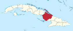
Camagüey (Spanish pronunciation: [kamaˈ(ɣ)wej]) is the largest of the provinces of Cuba. Its capital is Camagüey. Other towns include Florida and Nuevitas.
Camagüey Province | |
|---|---|
Province of Cuba | |
| Province of Camagüey | |
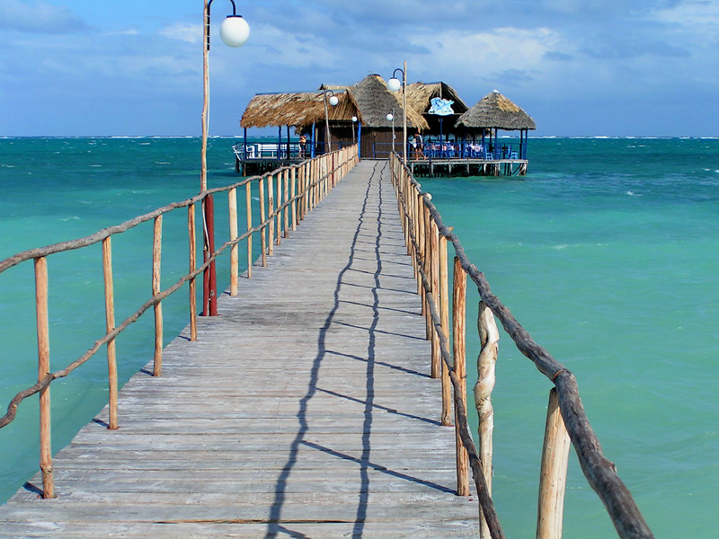 Santa Lucia Beach | |
 Coat of arms | |
 | |
| Country | Cuba |
| Capital | Camagüey |
| Area | |
| • Total | 15,413.82 km2 (5,951.31 sq mi) |
| Population (2018)[1] | |
| • Total | 1,531,909 |
| • Density | 99/km2 (260/sq mi) |
| Time zone | UTC-5 (EST) |
| Area code | +53-32 |
| HDI (2019) | 0.760[2] high · 14th of 16 |
| Website | Portal Camagüey |
Geography
Camagüey is mostly low lying, with no major hills or mountain ranges passing through the province. Numerous large cays (including what used to be one of Fidel Castro's favourite fishing spots; the Archipiélago Jardines de la Reina) characterize the southern coasts, while the northern coast is lined by Jardines del Rey of the Sabana-Camagüey Archipelago.
Sandy beaches are found on both coasts also, and despite a large potential for tourism, the province has seen little development in that area with the exception of Santa Lucía beach, on the province's North coast.
Economy
The economy of the Camagüey province is primarily cattle and sugar (in the north and south) farming, and the province is known for its cowboy culture, with rodeos frequently held. Chickens and rice are also farmed, and a small citrus fruit industry exists. The capital city also has one of the few breweries on the island.
Municipalities
| Municipality | Population (2004) | Area (km2) | Location | Remarks |
|---|---|---|---|---|
| Camagüey | 324,921 | 1,106 | 21.38389°N 77.90722°W | Provincial capital |
| Carlos M. de Céspedes | 25,707 | 653 | 21.57694°N 78.27750°W | |
| Esmeralda | 29,953 | 1,480 | 21.85611°N 78.11111°W | |
| Florida | 73,612 | 1,800 | 21.52944°N 78.22250°W | |
| Guáimaro | 57,086 | 1,847 | 21.05889°N 77.34778°W | |
| Jimaguayú | 21,169 | 799 | 21.26667°N 77.83028°W | |
| Minas | 38,517 | 1,015 | 21.48944°N 77.60472°W | |
| Najasa | 16,470 | 921 | 21.08389°N 77.74694°W | |
| Nuevitas | 44,882 | 415 | 21.54028°N 77.26444°W | |
| Santa Cruz del Sur | 51,335 | 1,122 | 20.71944°N 77.99083°W | |
| Sibanicú | 31,117 | 736 | 21.23917°N 77.52083°W | |
| Sierra de Cubitas | 18,589 | 549 | 21.73306°N 77.77056°W | |
| Vertientes | 53,299 | 2,005 | 21.25722°N 78.14889°W |
References
- "Lugar que ocupa el territorio según la superficie y la población" (PDF). Una MIRADA a Cuba (in Spanish). Oficina Nacional de Estadísticas. Cuba. 2010.
- "Sub-national HDI - Area Database - Global Data Lab". hdi.globaldatalab.org. Retrieved 2022-01-24.
- Atenas.cu (2004). "2004 Population trends, by Province and Municipality" (in Spanish). Archived from the original on 2006-07-14. Retrieved 2007-10-06.
- Statoids (July 2003). "Municipios of Cuba". Retrieved 2007-10-06.
Further reading
- New York Public Library (1912). "Cuba: History and Description: Special Places: Puerto Principe (Province)". List of Works Relating to the West Indies.
External links
- (in Spanish) Portal Camagüey
| Current provinces | |||||||
|---|---|---|---|---|---|---|---|
| Current special municipality | |||||||
| Historical provinces |
| ||||||
| |||||||
Authority control | |
|---|---|
| National libraries | |
| Other |
|
На других языках
- [en] Camagüey Province
[ru] Камагуэй (провинция)
Камагуэ́й (исп. Camagüey) — провинция Кубы, расположенная в центральной части страны. На севере граничит с Атлантическим океаном, на юге с Карибским морем, на западе с провинцией Сьего-де-Авила, до 1975 входившей в её состав, на востоке с провинцией Лас-Тунас.Другой контент может иметь иную лицензию. Перед использованием материалов сайта WikiSort.org внимательно изучите правила лицензирования конкретных элементов наполнения сайта.
WikiSort.org - проект по пересортировке и дополнению контента Википедии