world.wikisort.org - Colombia
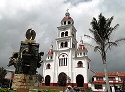
Villahermosa is a town and municipality in the Tolima department of Colombia. The population of the municipality was 12,574 as of the 1993 census. The municipality is also one of the most important coffee producers of Tolima's north.
This article uses bare URLs, which are uninformative and vulnerable to link rot. (September 2022) |
Villahermosa, Tolima | |
|---|---|
Municipality and town | |
 | |
 Flag  Seal | |
 Location of the municipality and town of Villahermosa, Tolima in the Tolima Department of Colombia. | |
| Country | |
| Department | Tolima Department |
| Area | |
| • Total | 264.7 km2 (102.2 sq mi) |
| Elevation | 2,079 m (6,821 ft) |
| Population (2015) | |
| • Total | 10,696 |
| • Density | 40/km2 (100/sq mi) |
| Time zone | UTC-5 (Colombia Standard Time) |
Climate
Villahermosa has a subtropical highland climate (Cfb). It has heavy rainfall year-round.
| Climate data for Villahermosa | |||||||||||||
|---|---|---|---|---|---|---|---|---|---|---|---|---|---|
| Month | Jan | Feb | Mar | Apr | May | Jun | Jul | Aug | Sep | Oct | Nov | Dec | Year |
| Average high °C (°F) | 19.7 (67.5) |
19.9 (67.8) |
20.1 (68.2) |
20.2 (68.4) |
20.4 (68.7) |
20.4 (68.7) |
20.3 (68.5) |
20.5 (68.9) |
20.4 (68.7) |
20.0 (68.0) |
19.9 (67.8) |
19.9 (67.8) |
20.1 (68.2) |
| Daily mean °C (°F) | 16.5 (61.7) |
16.6 (61.9) |
16.8 (62.2) |
17.1 (62.8) |
17.3 (63.1) |
17.1 (62.8) |
16.9 (62.4) |
17.0 (62.6) |
17.0 (62.6) |
16.7 (62.1) |
16.7 (62.1) |
16.6 (61.9) |
16.9 (62.4) |
| Average low °C (°F) | 13.6 (56.5) |
13.8 (56.8) |
14.0 (57.2) |
14.3 (57.7) |
14.3 (57.7) |
13.7 (56.7) |
13.5 (56.3) |
13.3 (55.9) |
13.6 (56.5) |
13.7 (56.7) |
13.7 (56.7) |
13.7 (56.7) |
13.8 (56.8) |
| Average rainfall mm (inches) | 161.1 (6.34) |
192.2 (7.57) |
242.4 (9.54) |
286.0 (11.26) |
292.9 (11.53) |
137.2 (5.40) |
108.1 (4.26) |
125.9 (4.96) |
232.0 (9.13) |
308.2 (12.13) |
270.8 (10.66) |
185.0 (7.28) |
2,541.8 (100.06) |
| Average rainy days | 16 | 16 | 20 | 22 | 21 | 15 | 13 | 13 | 17 | 22 | 21 | 18 | 214 |
| Average relative humidity (%) | 89 | 89 | 89 | 89 | 89 | 88 | 85 | 84 | 86 | 89 | 90 | 89 | 88 |
| Mean monthly sunshine hours | 133.3 | 107.3 | 114.7 | 108.0 | 133.3 | 165.0 | 186.0 | 186.0 | 153.0 | 127.1 | 105.0 | 127.1 | 1,645.8 |
| Mean daily sunshine hours | 4.3 | 3.8 | 3.7 | 3.6 | 4.3 | 5.5 | 6.0 | 6.0 | 5.1 | 4.1 | 3.5 | 4.1 | 4.5 |
| Source: [1] | |||||||||||||
References
На других языках
- [en] Villahermosa, Tolima
[es] Villahermosa (Tolima)
Villahermosa es un municipio de Colombia, situado en la parte noroccidental del departamento del Tolima; forma parte del parque de los nevados, principal sitio turístico, donde nacen los ríos Azufrado y Lagunilla.Текст в блоке "Читать" взят с сайта "Википедия" и доступен по лицензии Creative Commons Attribution-ShareAlike; в отдельных случаях могут действовать дополнительные условия.
Другой контент может иметь иную лицензию. Перед использованием материалов сайта WikiSort.org внимательно изучите правила лицензирования конкретных элементов наполнения сайта.
Другой контент может иметь иную лицензию. Перед использованием материалов сайта WikiSort.org внимательно изучите правила лицензирования конкретных элементов наполнения сайта.
2019-2025
WikiSort.org - проект по пересортировке и дополнению контента Википедии
WikiSort.org - проект по пересортировке и дополнению контента Википедии