world.wikisort.org - Colombia
Ibagué (Spanish pronunciation: [iβaˈɣe]) (referred to as San Bonifacio de Ibagué del Valle de las Lanzas during the Spanish period) is the capital of Tolima, one of the 32 departments that make up the Republic of Colombia.[3] The city is located in the center of the country, on the central mountain range of the Colombian Andes, near Nevado del Tolima. It is one of the most populous cities in the country, with about 529,635 (according to the 2018 census) inhabitants, making it the seventh (7th) most populous in Colombia.[4] It was founded on October 14, 1550, by the Spanish captain Andrés López de Galarza. The city of Ibagué is divided into 13 communes and the rural area has 17 corregimientos.[5] As the capital of the department of Tolima the city hosts the Government of Tolima, the Departmental Assembly, and the Attorney General's Office. It is the main epicenter of political, economic, administrative, business, art, culture, and tourism activities in the area.
Ibagué | |
|---|---|
Municipio | |
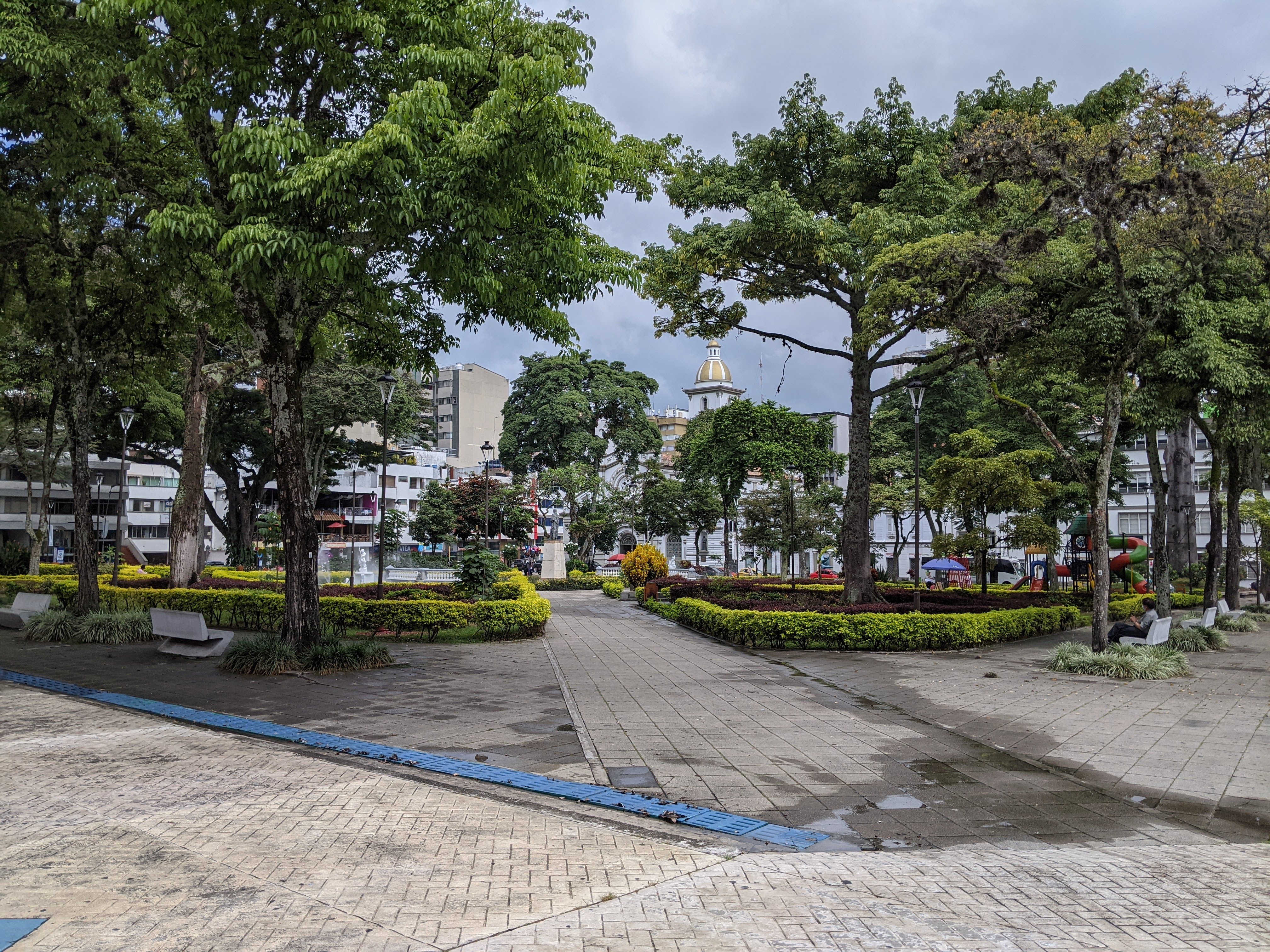
     From the top: Panorama of Ibagué from the east, Ibagué's city hall, Governorate of Tolima, Ocobos flowered in front of the Cathedral of Ibague and Art Museum of Tolima. | |
 Flag  Seal | |
| Nickname: Ciudad musical de Colombia (Musical city of Colombia)[1] | |
 Location of the city of Ibagué in Tolima. | |
 Ibagué Location in Colombia | |
| Coordinates: 4°26′N 75°14′W | |
| Country | |
| Region | Andean Region |
| Department | Department of Tolima |
| Foundation | October 14, 1550 |
| Government | |
| • Mayor | Andrés Hurtado |
| Area | |
| • Municipio | 1,498 km2 (578 sq mi) |
| Elevation | 1,285 m (4,216 ft) |
| Population (2018)[2] | |
| • Municipio | 529,635 |
| • Urban | 492,554 |
| • Rural | 37,081 |
| Demonym(s) | Ibaguereño, ibaguereña |
| Time zone | UTC-5 (Eastern Time Zone) |
| Postal code | 730001-730019 |
| Area code | 57 + 8 |
| Website | ibague |
Ibagué maintains one of the major urban economies of Colombia and could grow in prominence within South America[6] with its development potential and competitive national and international business centers, industry, and infrastructure. It is one of three cities in the country chosen by the World Trade Center Association (WTCA) to build headquarters along with Cali,[7] adding to the one existing in Bogotá. The economy of Ibagué is based primarily on the industrial, tourism, and agricultural sectors, with its textile industry[8] being the third largest in Colombia.[9] According to "Doing Business" from the World Bank in Washington DC, Ibagué tops the ranking of the cities with greater ease of doing business and investment in the country after Manizales.[10] The city is also part of the Colombian coffee growing axis.
The city is known as "The Musical Capital of Colombia and America", thanks to the Conservatory of Tolima[11] (one of the most prestigious and important in Colombia),[12] folklore festivities,[13] and its many monuments referring to music. The city's main educational institutions are the University of Tolima, the University of Ibagué, the Universidad Nacional Abierta y a Distancia (UNAD) and the Conservatory of Tolima.
History
Ibagué was founded by Andrés López de Galarza on October 14 of 1550, as "Villa de San Bonifacio de Ibagué del Valle de las Lanzas" ("Town of Saint Boniface of Ibagué of the Valley of the Spears") in a nearby location where now lies the urban area of the neighboring municipality of Cajamarca about 42 km (26 miles) to the west of Ibagué's current whereabouts. The indigenous Pijaos commanded by cacique Ibagué were not fond of Spaniards colonizing the area so the city was re-founded in its current location on February 7, 1551. [citation needed]
From April to December 1854, Ibagué was briefly the capital of the New Granada following a coup d'etat promoted by general José María Melo. In 1908, when the department of Tolima was created, Ibagué was designated as its capital. The University of Tolima was founded in 1945, and was raised to state university status in 1954. The city is also the home of the Roman Catholic Archdiocese of Ibagué.
Geography
Ibagué is located in the Colombian Andean region, in the center of the department of Tolima, surrounded by mountains on all sides with the exception of a plateau which extends to the east.
Volcanism
Ibagué lies within the Andean Volcanic Belt. It has two active volcanoes in its immediate vicinity: the Nevado del Tolima, 28 km (17 mi) NW of the city, and the Cerro Machín, 17 km (11 mi) west of the city center but still within the Municipality of Ibagué. The city is one access point to Los Nevados National Park, the other being Manizales.
Cerro Machín has been dormant for the last 800 years, but seismological activity has been registered recently causing several earthquakes. The volcano is classified as "III – Changes in behavior of volcanic activity" by Ingeominas, the Colombian Institute for Geology and Mining.[14] A map of menaced areas has been published indicating that in the event of an eruption the city of Ibagué would not be affected despite its proximity to the volcano.[15]
Demographics
The total population of the municipality of Ibagué (including urban and rural areas), according to the 2018 census, was 529,635 inhabitants, of which 492,554 resided in the urban area.[16]
Infrastructure
Transportation
Municipal transport is managed by several local bus companies that operate minibuses throughout the city and to neighboring villages.
Ibagué lies at the intersection of national roads 40 and 43, connecting the city to Magdalena River Valley and Bogotá to the east, Armenia and the Valle del Cauca to the west, and Honda to the north. There is a long distance bus terminal with connections to most big cities in Colombia. There are frequent connections to Bogotá, Cali, Medellín, and several overnight buses to Cartagena, Barranquilla, and seasonal services to Santa Marta.
About 10 km (6 mi) east of the city lies Perales Airport which has several flights a day to Bogotá and Medellín.
Climate
Ibagué features a tropical rainforest climate under the Köppen climate classification, albeit a relatively cooler version of the climate due to the high altitude. Although the city does experience noticeably drier conditions during and around the months of January and July, the city has no true dry season month, as all twelve months see on average more than 60 mm (2.4 in) of rain. As is commonplace in areas with this climate, temperatures are relatively consistent throughout the course of the year in Ibagué, with average high temperatures of about 28 °C or 82.4 °F and average low temperatures of about 18 °C or 64.4 °F. On average Ibagué sees 1,700 mm (66.9 in) of rain annually.
| Climate data for Ibagué, Colombia (Perales Airport) 1981-2010 | |||||||||||||
|---|---|---|---|---|---|---|---|---|---|---|---|---|---|
| Month | Jan | Feb | Mar | Apr | May | Jun | Jul | Aug | Sep | Oct | Nov | Dec | Year |
| Record high °C (°F) | 34.4 (93.9) |
35.4 (95.7) |
34.4 (93.9) |
34.2 (93.6) |
33.2 (91.8) |
33.6 (92.5) |
35.0 (95.0) |
36.4 (97.5) |
36.0 (96.8) |
34.8 (94.6) |
31.9 (89.4) |
34.2 (93.6) |
36.4 (97.5) |
| Average high °C (°F) | 28.8 (83.8) |
29.1 (84.4) |
28.8 (83.8) |
28.2 (82.8) |
28.2 (82.8) |
28.9 (84.0) |
29.8 (85.6) |
30.8 (87.4) |
29.9 (85.8) |
28.2 (82.8) |
27.5 (81.5) |
28.0 (82.4) |
28.8 (83.8) |
| Daily mean °C (°F) | 23.8 (74.8) |
24.2 (75.6) |
24.0 (75.2) |
23.7 (74.7) |
23.8 (74.8) |
24.1 (75.4) |
24.5 (76.1) |
25.2 (77.4) |
24.6 (76.3) |
23.5 (74.3) |
23.1 (73.6) |
23.3 (73.9) |
24.0 (75.2) |
| Average low °C (°F) | 18.8 (65.8) |
19.3 (66.7) |
19.3 (66.7) |
19.3 (66.7) |
19.3 (66.7) |
19.1 (66.4) |
18.9 (66.0) |
19.2 (66.6) |
19.0 (66.2) |
19.0 (66.2) |
19.0 (66.2) |
18.9 (66.0) |
19.1 (66.4) |
| Record low °C (°F) | 15.3 (59.5) |
15.2 (59.4) |
14.8 (58.6) |
15.6 (60.1) |
16.2 (61.2) |
15.2 (59.4) |
15.2 (59.4) |
10.6 (51.1) |
14.4 (57.9) |
16.0 (60.8) |
15.2 (59.4) |
15.4 (59.7) |
10.6 (51.1) |
| Average rainfall mm (inches) | 86.5 (3.41) |
109.1 (4.30) |
138.2 (5.44) |
227.1 (8.94) |
228.2 (8.98) |
110.6 (4.35) |
75.9 (2.99) |
78.2 (3.08) |
149.9 (5.90) |
205.6 (8.09) |
173.7 (6.84) |
108.6 (4.28) |
1,691.6 (66.6) |
| Average rainy days (≥ 1 mm) | 12 | 13 | 16 | 20 | 19 | 12 | 10 | 10 | 14 | 19 | 19 | 14 | 178 |
| Average relative humidity (%) | 77 | 77 | 79 | 81 | 81 | 77 | 70 | 66 | 72 | 80 | 83 | 81 | 77 |
| Mean monthly sunshine hours | 179.8 | 144.1 | 139.5 | 138.0 | 155.0 | 168.0 | 192.2 | 195.3 | 180.0 | 158.1 | 141.0 | 164.3 | 1,955.3 |
| Mean daily sunshine hours | 5.8 | 5.1 | 4.5 | 4.6 | 5.0 | 5.6 | 6.2 | 6.3 | 6.0 | 5.1 | 4.7 | 5.3 | 5.3 |
| Source: Instituto de Hidrologia Meteorologia y Estudios Ambientales[17][18][19] | |||||||||||||
Neighborhoods
- Licapeña
Notable people
- Andres Marin, competitive ice climber
- Darío Ortiz Robledo, artist[20]
- Óscar Escandón, boxer
- Jairo Alberto Bocanegra Pena, singer
- Patricia Caicedo, soprano
- Estefanía Gómez, actress
- James Cañón, novelist
- James Rodríguez, soccer player
Sports
This section needs to be updated. (June 2020) |
The Colombian Football Association announced that Ibagué will be one of the venue cities to host the 2016 FIFA Futsal World Cup,[21] although in the end it was not designated as the venue for the sporting event.[22]
Twin towns – sister cities
Ibagué is twinned with:[23]
 Chengdu, China
 Vitoria-Gasteiz, Spain
References
- City of Ibagué (Tolima). Mycities.co. Retrieved June 2, 2014
- https://www.dane.gov.co/files/varios/informacion-capital-DANE-2019.pdf [bare URL PDF]
- "What are the departments of Colombia". colombiainfo.org. Retrieved March 23, 2015.
- https://www.dane.gov.co/files/varios/informacion-capital-DANE-2019.pdf [bare URL PDF]
- "mapa de comunas de ibague" (PDF) (in Spanish). 2010.[permanent dead link]
- "world trade center ibague" (in Spanish). 2010.
- "world trade center Colombia" (in Spanish). 2010.
- colombianparadise (2010). "economía de ibague" (in Spanish).
- El tiempo (2010). "ibague,ciudad de la confeccion" (in Spanish).
- ibague es la segunda ciudad negociante del país (2010). "ibague seuna ciudad finanicera y de negocios del pais/web2/joomla/documentos/mapa_comunas.pdf" (in Spanish).
- conservatorio de ibague (2010). "conservatorio de ibague" (in Spanish).
- conservatorio del tolima (2010). "conservatorio del tolima" (in Spanish).
- reinado nacional del folclor (2010). "reinado nacional del folclor" (in Spanish). Archived from the original on June 19, 2013. Retrieved May 22, 2013.
- "Ingeominas" (in Spanish). Manizales, Colombia: Ingeominas. August 1, 2009. Archived from the original on June 26, 2007. Retrieved August 13, 2009.
- "Mapa de amenaza del Cerro Machín" (in Spanish). Manizales, Colombia: Ingeominas. December 9, 2008. Archived from the original on October 13, 2008. Retrieved August 13, 2009.
- https://www.dane.gov.co/files/varios/informacion-capital-DANE-2019.pdf [bare URL PDF]
- "Promedios Climatológicos 1981–2010" (in Spanish). Instituto de Hidrologia Meteorologia y Estudios Ambientales. Archived from the original on August 15, 2016. Retrieved August 16, 2016.
- "Promedios Climatológicos 1971–2000" (in Spanish). Instituto de Hidrologia Meteorologia y Estudios Ambientales. Archived from the original on August 15, 2016. Retrieved August 16, 2016.
- "Tiempo y Clima" (in Spanish). Instituto de Hidrologia Meteorologia y Estudios Ambientales. Archived from the original on August 15, 2016. Retrieved August 16, 2016.
- "Darío Ortiz abrió su 'Ventana al Mundo'", El Espectador, September 29, 2008 (in Spanish).
- "Copa Mundial de Futsal de la FIFA se jugará en Colombia en 2016". fcf.com.co/. May 28, 2013. Archived from the original on December 3, 2013.
- "Cali, Medellín y Bucaramanga, sedes del Mundial de Futsal". January 29, 2016.
- "Menu: International cooperation". ibaguecreativa.gov.co. Ibagué Creativa. Retrieved December 22, 2021.
External links
- El Nuevo Día (local journal)
- ElOlfato.com (digital magazine)
- Ecos del Combeima (local radio station and digital radio)
- Ondas de Ibagué (local radio station and digital radio)
 Media related to Ibagué at Wikimedia Commons
 Ibagué travel guide from Wikivoyage
Municipalities in Tolima Department | ||
|---|---|---|
| ||
На других языках
- [en] Ibagué
[es] Ibagué
Ibagué es un municipio colombiano ubicado en el centro-occidente de Colombia, sobre la Cordillera Central de los Andes entre el Cañón del Combeima y el Valle del Magdalena, en cercanías del Nevado del Tolima. Es la capital del departamento de Tolima. Se encuentra a una altitud promedio de 1285 m.s.n.m; su área urbana se divide en 13 comunas y su zona rural en más de 17 corregimientos, 144 veredas y 14 inspecciones. Fue fundada el 14 de octubre de 1550 por el capitán español Andrés López de Galarza como Villa de San Bonifacio de Ibagué del Valle de las Lanzas, lo que la convierte en una de las ciudades más antiguas de América. Por ser una ciudad capital, alberga la Gobernación del Tolima, el Palacio de Justicia, el Palacio Municipal, la Asamblea Departamental, la sede departamental de la Fiscalía General de la Nación, y es el principal epicentro político, industrial, comercial, cultural, financiero y turístico del departamento.[ru] Ибаге
Ибаге́ (исп. Ibague) — город, расположенный в центре Колумбии. Административный центр департамента Толима.Другой контент может иметь иную лицензию. Перед использованием материалов сайта WikiSort.org внимательно изучите правила лицензирования конкретных элементов наполнения сайта.
WikiSort.org - проект по пересортировке и дополнению контента Википедии