world.wikisort.org - Colombia
Soracá is a town and municipality in the Colombian Department of Boyacá, part of the subregion of the Central Boyacá Province. Soracá borders the municipalities of Chivatá in the north, Siachoque, Viracacha and Ramiriquí in the east, Boyacá in the south and the department capital Tunja in the west.[1]
Soracá | |
|---|---|
Municipality and town | |
 View of Soracá | |
 Flag | |
 Location of the municipality and town of Soracá in the Boyacá Department of Colombia | |
| Country | |
| Department | Boyacá Department |
| Province | Central Boyacá Province |
| Founded | 7 October 1776 |
| Government | |
| • Mayor | José Misael Neva Ocación (2020-2023) |
| Area | |
| • Municipality and town | 57 km2 (22 sq mi) |
| • Urban | 27 km2 (10 sq mi) |
| Elevation | 2,942 m (9,652 ft) |
| Population (2015) | |
| • Municipality and town | 5,353 |
| • Density | 94/km2 (240/sq mi) |
| • Urban | 751 |
| Time zone | UTC-5 (Colombia Standard Time) |
| Website | Official website |
Etymology
In Chibcha, Soracá means "ruling mansion of the sovereign".[2]
History
The area of Soracá was part of the zacazgo of Hunza, presently known as Tunja in the time before the Spanish conquest of the Muisca. The Muisca inhabiting the Altiplano Cundiboyacense and their confederation were an advanced civilization who spoke Chibcha. In the 1530s the Spanish conquistadores led by Gonzalo Jiménez de Quesada entered the territories of the Muisca.
Economy
Main economical activities in Soracá are dairy production, mining and production of bricks.[1]
Born in Soracá
- Graciano Fonseca, professional cyclist
Gallery
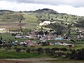 View of Soracá
 Soracá
 Soracá


 Medical center
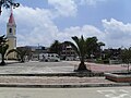 Central park
 Rural part of Soracá


References
- (in Spanish) Official website Soracá
- (in Spanish) Etymology Soracá
Provinces and Municipalities in Boyacá Department | |
|---|---|
| Central Boyacá Province | |
| Northern Boyacá Province |
|
| Western Boyacá Province |
|
| Eastern Boyacá Province | |
| Gutiérrez Province |
|
| La Libertad Province |
|
| Lengupá Province |
|
| Márquez Province | |
| Neira Province |
|
| Ricaurte Province |
|
| Sugamuxi Province | |
| Tundama Province | |
| Valderrama Province | |
| Boyacá Frontier District |
|
| Boyacá Special Handling Zone | |
See also: List of municipalities in Boyacá | |
На других языках
- [en] Soracá
[es] Soracá
Soracá es un municipio colombiano, ubicado en la provincia del Centro, del Departamento de Boyacá. El territorio del municipio se halla sobre el altiplano Cundiboyacense y es conocido por los cultivos de clima frío como la papa (tubérculo) y el ganado vacuno. Dista 7 km de la ciudad de Tunja, capital del departamento.[ru] Сорака
Сорака (исп. Soracá) — город и муниципалитет в центральной части Колумбии, на территории департамента Бояка. Входит в состав Центральной (исп.) (рус. провинции.Другой контент может иметь иную лицензию. Перед использованием материалов сайта WikiSort.org внимательно изучите правила лицензирования конкретных элементов наполнения сайта.
WikiSort.org - проект по пересортировке и дополнению контента Википедии