world.wikisort.org - Colombia
Santa Sofía is a town and municipality in the Department of Boyacá, part of the subregion of the Ricaurte Province, Colombia. The urban centre of Santa Sofía is located at an altitude of 2,387 metres (7,831 ft) on the Altiplano Cundiboyacense, with the highest elevated parts of the municipality, that have a páramo ecosystem, reaching 3,000 metres (9,800 ft). Santa Sofía borders Moniquirá in the north, Gachantivá in the west, Villa de Leyva in the southeast, Sutamarchán in the south, Saboyá in the southwest, and Puente Nacional, Santander in the west.[1]
Santa Sofía
Guatoque | |
|---|---|
Municipality and town | |
 Central square of Santa Sofía | |
 Location of the municipality and town of Santa Sofía in the Boyacá Department of Colombia | |
| Coordinates: 5°45′N 73°35′W | |
| Country | |
| Department | Boyacá Department |
| Province | Ricaurte Province |
| Founded | 10 January 1810 |
| Founded by | Spanish colonists ordered by Amar y Borbón |
| Government | |
| • Mayor | William Gustavo Parra Merchán (2020-2023) |
| Area | |
| • Municipality and town | 78 km2 (30 sq mi) |
| • Urban | 18 km2 (7 sq mi) |
| Elevation | 2,387 m (7,831 ft) |
| Population (2015) | |
| • Municipality and town | 2,704 |
| • Density | 35/km2 (90/sq mi) |
| • Urban | 721 |
| Time zone | UTC-5 (Colombia Standard Time) |
| Website | Official website |
Etymology
Originally, Santa Sofía was called Guatoque, a name derived from Muysccubun, meaning "creek of the mountain". The name was changed in 1906 to Santa Sofía, because mail that was meant to go to Guateque, in southern Boyacá, was accidentally delivered in Guatoque. The name Santa Sofía was given to the town honouring Sofía Ángulo de Reyes, spouse of the then president of Colombia Rafael Reyes.[1]
History
The area of Santa Sofía before the Spanish conquest was inhabited by the Muisca, who used the area to cross the lands towards the northern parts of their Muisca Confederation.
It was in nearby Sorocotá that De Quesada and his men first discovered the potato in 1537[2][3][4] together with maize and beans[5] alongside many aspects of local culture and customs as described in the History of the conquest of the New kingdom of Granada by Juan de Castellanos.[6]
Within the boundaries of the municipalities is located the Hoyo de la Romera, a sinkhole where unfaithful Muisca women were punished.[citation needed]
Santa Sofía, then as Guatoque, was founded by Spanish colonists ordered by Amar y Borbón on January 10, 1810, just before the independence of Colombia from the Spanish Empire was called.[1]
Economy
Main economical activities of Santa Sofía are livestock farming and agriculture, especially curuba, tomatoes and strawberries. Other products cultivated are potatoes, maize, peas, beans, sugarcane and yuca.[1]
Tourism
Santa Sofía is a rural community that gives access to the Guatoque Páramo and the Paso del Ángel, an ancient indigenous road. There are various caves and waterfalls located around Santa Sofía.[1]
Gallery
 Central square
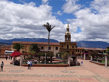 Central square
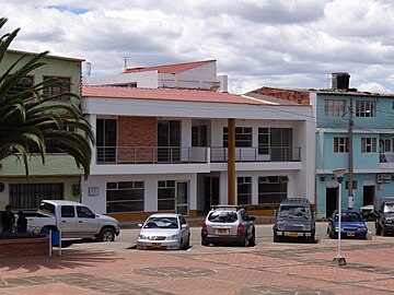 Town council building
 Greenhouses


 Guatoque creek
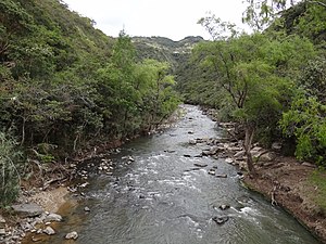 Moniquirá River
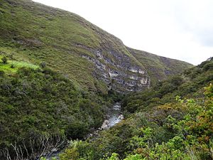 Paso del Ángel
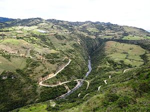 Ancient road, Paso del Ángel
 Hoyo de la Romera


References
| Wikimedia Commons has media related to Santa Sofía, Boyacá. |
- (in Spanish) Official website Santa Sofía
- Contributions from Texas Research Foundation. Texas Research Foundation. 1962.
- Pemberton, John (2011). Conquistadors: Searching for El Dorado: The Terrifying Spanish Conquest of the Aztec and Inca Empires. Canary Press eBooks. ISBN 978-1-907795-96-1.
- Sokolov, Raymond (1993-04-05). Why We Eat What We Eat: How Columbus Changed the Way the World Eats. Simon and Schuster. ISBN 978-0-671-79791-1.
- Brücher, Heinz (2012-12-06). Useful Plants of Neotropical Origin: and Their Wild Relatives. Springer Science & Business Media. ISBN 978-3-642-73313-0.
- Snodgrass, Mary Ellen (2012-09-15). World Food: An Encyclopedia of History, Culture and Social Influence from Hunter Gatherers to the Age of Globalization: An Encyclopedia of History, Culture and Social Influence from Hunter Gatherers to the Age of Globalization. Routledge. ISBN 978-1-317-45160-0.
Provinces and Municipalities in Boyacá Department | |
|---|---|
| Central Boyacá Province |
|
| Northern Boyacá Province |
|
| Western Boyacá Province |
|
| Eastern Boyacá Province | |
| Gutiérrez Province | |
| La Libertad Province |
|
| Lengupá Province |
|
| Márquez Province | |
| Neira Province |
|
| Ricaurte Province |
|
| Sugamuxi Province | |
| Tundama Province | |
| Valderrama Province | |
| Boyacá Frontier District |
|
| Boyacá Special Handling Zone |
|
See also: List of municipalities in Boyacá | |
На других языках
- [en] Santa Sofía, Boyacá
[es] Santa Sofía (Boyacá)
Santa Sofía es un municipio colombiano ubicado en la Provincia de Ricaurte en el departamento de Boyacá. Está situado a 12 km al norte de Villa de Leyva y a 77 km de Tunja la capital del departamento.[ru] Санта-София (Колумбия)
Санта-София (исп. Santa Sofía) — небольшой город и муниципалитет в центральной части Колумбии, на территории департамента Бояка. Входит в состав провинции Рикаурте (исп.) (рус..Другой контент может иметь иную лицензию. Перед использованием материалов сайта WikiSort.org внимательно изучите правила лицензирования конкретных элементов наполнения сайта.
WikiSort.org - проект по пересортировке и дополнению контента Википедии