world.wikisort.org - Colombia
Puerto Boyacá is a Colombian river-port town and municipality by the Magdalena River in the Boyacá Department, where is also considered a Special Handling Zone due to its port status. Its main industries are oil exploration and processing. In the 1980s and early 1990s, Puerto Boyacá was affected intensively by the Colombian Armed Conflict.
Puerto Boyacá | |
|---|---|
Municipality and town | |
 Flag  Seal | |
 Location of the municipality and town of Puerto Boyacá in the Boyacá Department of Colombia | |
 Puerto Boyacá Location in Colombia | |
| Coordinates: 5°58′41″N 74°35′23″W | |
| Country | |
| Department | Boyacá Department |
| Province | Boyacá Special Handling Zone |
| Founded | December 14, 1957 |
| Government | |
| • Mayor | Jicly Esgardo Mutis Isaza (2020-2023) |
| Area | |
| • Municipality and town | 1,472 km2 (568 sq mi) |
| • Urban | 4.03 km2 (1.56 sq mi) |
| Elevation | 145 m (476 ft) |
| Population (2015) | |
| • Municipality and town | 55,286[1] |
| Demonym(s) | Puertoboyacense |
| Time zone | UTC-5 (Colombia Standard Time) |
| Postal code | 152201-19 |
| Area code(s) | 57 + 8 |
| Website | Official website |
Borders
- North - departments of Bolívar, Santander
- West - Magdalena River and Puerto Berrío, Puerto Nare, Puerto Triunfo and Sonsón municipalities of Antioquia Department
- South - Puerto Salgar and Yacopí municipalities of Cundinamarca
- East - municipality of Otanche (Boyacá)
Born in Puerto Boyacá
- Fredy Guarín, Colombian football player
Gallery
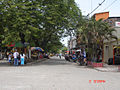 Puerto Boyacá typical street
- El Centro de la ciudad. Downtown city.

Other information
- Market Day: Sunday
- Distance from Tunja: 373 km
- Median temperature: 32 °C
Climate
| Month | Jan | Feb | Mar | Apr | May | Jun | Jul | Aug | Sep | Oct | Nov | Dec | Year |
|---|---|---|---|---|---|---|---|---|---|---|---|---|---|
| Record high °C (°F) | 38.6 (101.5) |
39.4 (102.9) |
40.0 (104.0) |
37.4 (99.3) |
37.0 (98.6) |
38.0 (100.4) |
41.2 (106.2) |
41.2 (106.2) |
39.0 (102.2) |
37.4 (99.3) |
37.4 (99.3) |
37.4 (99.3) |
38.7 (101.7) |
| Average high °C (°F) | 32.7 (90.9) |
33.0 (91.4) |
32.3 (90.1) |
32.2 (90.0) |
32.3 (90.1) |
32.9 (91.2) |
33.6 (92.5) |
33.8 (92.8) |
32.5 (90.5) |
31.5 (88.7) |
31.4 (88.5) |
32.0 (89.6) |
32.5 (90.5) |
| Daily mean °C (°F) | 28.1 (82.6) |
28.1 (82.6) |
27.8 (82.0) |
27.7 (81.9) |
27.8 (82.0) |
27.9 (82.2) |
28.4 (83.1) |
28.3 (82.9) |
27.6 (81.7) |
27.0 (80.6) |
27.2 (81.0) |
27.6 (81.7) |
27.6 (81.7) |
| Average low °C (°F) | 23.4 (74.1) |
23.7 (74.7) |
23.4 (74.1) |
23.2 (73.8) |
23.1 (73.6) |
23.4 (74.1) |
23.2 (73.8) |
23.3 (73.9) |
22.9 (73.2) |
22.8 (73.0) |
23.3 (73.9) |
23.7 (74.7) |
23.3 (73.9) |
| Record low °C (°F) | 20.0 (68.0) |
20.2 (68.4) |
18.0 (64.4) |
17.4 (63.3) |
16.8 (62.2) |
20.0 (68.0) |
20.2 (68.4) |
20.0 (68.0) |
19.0 (66.2) |
19.4 (66.9) |
20.0 (68.0) |
20.6 (69.1) |
19.3 (66.7) |
| Average precipitation mm (inches) | 64 (2.5) |
112 (4.4) |
153 (6.0) |
246 (9.7) |
234 (9.2) |
154 (6.1) |
143 (5.6) |
155 (6.1) |
239 (9.4) |
295 (11.6) |
191 (7.5) |
99 (3.9) |
2,086 (82.1) |
| Average rainy days (≥ 1 mm) | 7 | 11 | 13 | 18 | 20 | 18 | 16 | 16 | 19 | 21 | 16 | 10 | 183 |
| Average relative humidity (%) | 76 | 76 | 78 | 80 | 80 | 78 | 75 | 74 | 78 | 81 | 81 | 79 | 78 |
| Source: Instituto de Hidrología, Meteorología y Estudios Ambientales (IDEAM)[2] | |||||||||||||
References
- Departamento Administrativo Nacional de Estadística (DANE). Resultados y proyecciones (2005-2020) del censo 2005. Retrieved 17 June 2015.
- "Promedios 71-00" (in Spanish). IDEAM. Retrieved 30 April 2019.
External links
- (in Spanish) Puerto Boyacá municipality official website
Provinces and Municipalities in Boyacá Department | |
|---|---|
| Central Boyacá Province |
|
| Northern Boyacá Province |
|
| Western Boyacá Province |
|
| Eastern Boyacá Province | |
| Gutiérrez Province |
|
| La Libertad Province |
|
| Lengupá Province |
|
| Márquez Province | |
| Neira Province |
|
| Ricaurte Province |
|
| Sugamuxi Province | |
| Tundama Province | |
| Valderrama Province | |
| Boyacá Frontier District |
|
| Boyacá Special Handling Zone | |
See also: List of municipalities in Boyacá | |
This Boyacá Department location article is a stub. You can help Wikipedia by expanding it. |
На других языках
- [en] Puerto Boyacá
[ru] Пуэрто-Бояка
Пуэрто-Бояка (исп. Puerto Boyacá) — город и муниципалитет в центральной части Колумбии, на территории департамента Бояка. Административный центр Специальной зоны Манехо.Текст в блоке "Читать" взят с сайта "Википедия" и доступен по лицензии Creative Commons Attribution-ShareAlike; в отдельных случаях могут действовать дополнительные условия.
Другой контент может иметь иную лицензию. Перед использованием материалов сайта WikiSort.org внимательно изучите правила лицензирования конкретных элементов наполнения сайта.
Другой контент может иметь иную лицензию. Перед использованием материалов сайта WikiSort.org внимательно изучите правила лицензирования конкретных элементов наполнения сайта.
2019-2025
WikiSort.org - проект по пересортировке и дополнению контента Википедии
WikiSort.org - проект по пересортировке и дополнению контента Википедии