world.wikisort.org - China
Qian Gorlos Mongol Autonomous County (simplified Chinese: 前郭尔罗斯蒙古族自治县; traditional Chinese: 前郭爾羅斯蒙古族自治縣; pinyin: Qián Guō'ěrluósī Měnggǔzú Zìzhìxiàn), or simply Qian Gorlos County, commonly abbreviated as Qianguo County, is a county of northwestern Jilin province, China. It is under the administration of Songyuan City. Gorlos Mongols live here. Formerly known as, Qian Gorlos Banner.
Qian Gorlos County
ᠡᠮᠦᠨᠡᠳᠦ ᠭᠣᠷᠯᠣᠰ ᠰᠢᠶᠠᠨ 前郭尔罗斯县 | |
|---|---|
Autonomous county | |
ᠡᠮᠦᠨᠡᠳᠦ ᠭᠣᠷᠯᠣᠰ ᠮᠣᠩᠭᠣᠯ ᠥᠪᠡᠷᠲᠡᠭᠡᠨ ᠵᠠᠰᠠᠬᠤ ᠰᠢᠶᠠᠨ Qian Gorlos Mongol 前郭尔罗斯蒙古族自治县 Autonomous County | |
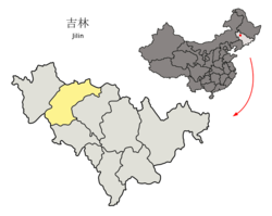
 Qian Gorlos in Songyuan | |
 Songyuan in Jilin | |
| Coordinates: 45°06′50″N 124°51′04″E | |
| Country | People's Republic of China |
| Province | Jilin |
| Prefecture-level city | Songyuan |
| Township-level divisions | 8 towns 14 townships |
| County seat | Qian Gorlos Town (前郭尔罗斯镇) |
| Area | |
| • Total | 5,117 km2 (1,976 sq mi) |
| Elevation | 133 m (436 ft) |
| Population | |
| • Total | 570,000 |
| • Density | 110/km2 (290/sq mi) |
| Time zone | UTC+8 (China Standard) |
| Postal code | 131100 |
| Area code(s) | 0438 |
Geography and climate
Qian Gorlos has a monsoon-influenced humid continental climate (Köppen Dwa), with long, bitterly cold and very dry winters and hot, humid summers. The monthly 24-hour average temperature ranges from −15.9 °C (3.4 °F) in January to 23.7 °C (74.7 °F) in July, and the annual mean is 5.78 °C (42.4 °F). Over two-thirds of the annual precipitation occurs from June to August, with barely any in the winter months. With monthly percent possible sunshine ranging from 52% in July to 68% in February and March, the area receives 2,732 hours of bright sunshine annually.
| Climate data for Qian Gorlos County (1981−2010 normals) | |||||||||||||
|---|---|---|---|---|---|---|---|---|---|---|---|---|---|
| Month | Jan | Feb | Mar | Apr | May | Jun | Jul | Aug | Sep | Oct | Nov | Dec | Year |
| Average high °C (°F) | −10.0 (14.0) |
−4.4 (24.1) |
4.0 (39.2) |
14.6 (58.3) |
22.0 (71.6) |
27.0 (80.6) |
28.2 (82.8) |
27.2 (81.0) |
22.0 (71.6) |
13.2 (55.8) |
1.1 (34.0) |
−7.6 (18.3) |
11.4 (52.6) |
| Daily mean °C (°F) | −15.9 (3.4) |
−10.8 (12.6) |
−2.0 (28.4) |
8.3 (46.9) |
16.0 (60.8) |
21.6 (70.9) |
23.7 (74.7) |
22.4 (72.3) |
15.9 (60.6) |
7.2 (45.0) |
−4.1 (24.6) |
−12.9 (8.8) |
5.8 (42.4) |
| Average low °C (°F) | −20.8 (−5.4) |
−16.2 (2.8) |
−7.5 (18.5) |
2.2 (36.0) |
9.9 (49.8) |
16.4 (61.5) |
19.5 (67.1) |
17.9 (64.2) |
10.5 (50.9) |
2.2 (36.0) |
−8.4 (16.9) |
−17.3 (0.9) |
0.7 (33.3) |
| Average precipitation mm (inches) | 1.8 (0.07) |
2.0 (0.08) |
7.4 (0.29) |
18.9 (0.74) |
35.5 (1.40) |
72.2 (2.84) |
128.1 (5.04) |
85.8 (3.38) |
33.9 (1.33) |
19.1 (0.75) |
7.0 (0.28) |
3.9 (0.15) |
415.6 (16.35) |
| Average precipitation days (≥ 0.2 mm) | 2.3 | 3.3 | 3.9 | 5.0 | 8.3 | 11.9 | 13.2 | 10.8 | 8.0 | 5.9 | 3.9 | 3.7 | 80.2 |
| Average relative humidity (%) | 64 | 57 | 48 | 47 | 50 | 62 | 76 | 75 | 66 | 59 | 60 | 65 | 61 |
| Mean monthly sunshine hours | 185.9 | 199.3 | 250.6 | 249.9 | 268.2 | 257.8 | 247.0 | 256.0 | 247.9 | 221.7 | 184.5 | 163.4 | 2,732.2 |
| Percent possible sunshine | 66 | 68 | 68 | 62 | 59 | 55 | 52 | 59 | 66 | 65 | 64 | 60 | 62 |
| Source: China Meteorological Administration (precipitation days and sunshine 1971–2000)[1][2] | |||||||||||||
Administrative divisions
The county administers eight towns and 14 townships.[3]
Towns:
- Qian Gorlos Town (前郭尔罗斯镇), Changshan (长山镇), Qaiborig (海渤日戈镇), Ulantuga (乌兰图嘎镇), Chaganhua (查干花镇), Wangfuzhan (王府站镇), Balang (八郎镇), Halamodu (哈拉毛都镇)
Townships:
- Baodian Township (宝甸乡), Pingfeng Township (平凤乡), Mongol Eili Township (蒙古艾里乡), Daliba Township (达里巴乡), Jilat Township (吉拉吐乡), Baiyilaga Township (白依拉嘎乡), Hongquan Township (洪泉乡), Eru Township (额如乡), Tauhote Township (套浩太乡), Changlong Township (长龙乡), Ulantala Township (乌兰塔拉乡), Dongsanjiazi Township (东三家子乡), Hotmangha Township (浩特芒哈乡), Ulan'odur Township (乌兰敖都乡)
Transport
- G12 Hunchun–Ulanhot Expressway
- G45 Daqing–Guangzhou Expressway
- China National Highway 203
- China National Highway 302
References
- 中国气象数据网 - WeatherBk Data (in Chinese (China)). China Meteorological Administration. Retrieved 2020-04-15.
- 中国地面国际交换站气候标准值月值数据集(1971-2000年). China Meteorological Administration. Archived from the original on 2013-09-21. Retrieved 2010-05-25.
- 2011年统计用区划代码和城乡划分代码:桥东区 (in Chinese). National Bureau of Statistics of the People's Republic of China. Retrieved 2013-01-16.
External links
Mongol-designated autonomous areas in China | |||||||||
|---|---|---|---|---|---|---|---|---|---|
| Regions |
|  | |||||||
| Prefectures and counties |
| ||||||||
| |||||||||
This Jilin location article is a stub. You can help Wikipedia by expanding it. |
На других языках
- [en] Qian Gorlos Mongol Autonomous County
[ru] Цянь-Горлос-Монгольский автономный уезд
Цянь-Горлос-Монгольский автономный уезд (кит. упр. 前郭尔罗斯蒙古族自治县, пиньинь Qián’guō'ěrluósī měnggǔzú zìzhìxiàn, монг. Өмнөд Горлосын Монгол өөртөө засах шянь) — автономный уезд в городском округе Сунъюань, провинция Гирин, КНР.Другой контент может иметь иную лицензию. Перед использованием материалов сайта WikiSort.org внимательно изучите правила лицензирования конкретных элементов наполнения сайта.
WikiSort.org - проект по пересортировке и дополнению контента Википедии