world.wikisort.org - China
Gongbo'gyamda County (Tibetan: ཀོང་པོ་རྒྱ་མདའ་རྫོང་, Wylie: kong po rgya mda' rdzong, ZYPY: Gongbo'gyamda Zong; simplified Chinese: 工布江达县; traditional Chinese: 工布江達縣; pinyin: Gōngbùjiāngdá Xiàn) is a county of Nyingchi (or Nyingtri) City in the Tibet Autonomous Region, lying approximately 275 km (171 mi) east of Lhasa at its central point. Its main geographical feature is Basum Tso, a green lake about 3,700 m (12,100 ft) above sea level.
Gongbo'gyamda County
工布江达县 • ཀོང་པོ་རྒྱ་མདའ་རྫོང་། | |
|---|---|
County | |
 Basum Tso | |
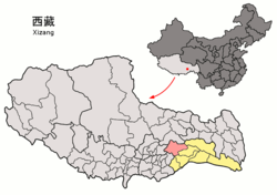 Location of Gongbo'gyamda County (red) in Nyingchi City (yellow) and the Tibet Autonomous Region | |
 Gongbo'gyamda Location of the seat in the Tibet Autonomous Region | |
| Coordinates: 30°23′38″N 93°27′10″E | |
| Country | People's Republic of China |
| Autonomous region | Tibet |
| Prefecture-level city | Nyingchi |
| Time zone | UTC+8 (China Standard) |
History
In 1587, Gyampo Monastery was established. Subsequently, a town named "Gyamda", meaning "valley outlet of Gyampo", was developed near the monastery. The region was originally under control of Derge Gyalpos. After the Qing Dynasty took over Derge, the region was managed by the Tibetan Government as Gyamda Dzong. In 1960, Gyamda Dzong merged with West Dengke Dzong to form the modern Gongbo'gyamda Dzong.[1]
Geography

Gongbo'gyamda County is located in the east of the Tibet Autonomous Region, to the south of the Nyainqentanglha Mountains, to the north of the Yarlung Tsangpo River and in the area of the middle branches of the Nyang River. With a population of 22,000, the county covers an area of 12,886 square kilometres. The average altitude of the county is 3,500 metres above sea level. The Pagsum Lake, with a total area of 26 square kilometres, is a famous lake.
Transport
- China National Highway 318
Economy and reserves
Water resources are abundant in Gongbo'gyamda County. The species of animals include leopard, red deer, black bear, brown bear, otter, monkey and black-necked crane, etc. There are almost a hundred of species of plants in the county, such as Yartsa Gunbu, fritillaria and snow lotus, etc.
Block raising is the main industry of the county. The Sichuan-Tibet Highway crosses the county. The total length of all roads reaches 380 km (240 mi).
Villages
References
- "Gyamda" (in Chinese). Chamdo City Government. Retrieved 15 December 2017.
External links
Nyingchi | ||
|---|---|---|
| District | Bayi |  |
| Counties |
| |
| Towns and villages |
| |
| Geography | ||
This Nyingchi, Tibet location article is a stub. You can help Wikipedia by expanding it. |
На других языках
- [en] Gongbo'gyamda County
[ru] Гонгбогьямда
Гонгбогьямда, ранее Джамда[1] (тиб. ཀོང་པོ་རྒྱ་མདའ་རྫོང་, Вайли: kong po rgya mda´ rdzong, кит. упр. 工布江达县, пиньинь Gōngbùjiāngdá xiàn, палл. Гунбуцзянда сянь) — уезд в городском округе Ньингчи, Тибетский автономный район, КНР. Название уезда в переводе с тибетского означает «глубокое ущелье».Другой контент может иметь иную лицензию. Перед использованием материалов сайта WikiSort.org внимательно изучите правила лицензирования конкретных элементов наполнения сайта.
WikiSort.org - проект по пересортировке и дополнению контента Википедии