world.wikisort.org - Canada
Sainte-Anne-de-la-Pocatière is a parish municipality in the Canadian province of Quebec, located in the Kamouraska Regional County Municipality.
Sainte-Anne-de-la-Pocatière | |
|---|---|
Parish municipality | |
 | |
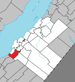 Location within Kamouraska RCM | |
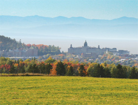
 Sainte-Anne-de-la-Pocatière Location in eastern Quebec | |
| Coordinates: 47°21′N 70°00′W[1] | |
| Country | |
| Province | |
| Region | Bas-Saint-Laurent |
| RCM | Kamouraska |
| Constituted | July 1, 1855 |
| Government | |
| • Mayor | François Lagacé |
| • Federal riding | Montmagny—L'Islet—Kamouraska—Rivière-du-Loup |
| • Prov. riding | Côte-du-Sud |
| Area | |
| • Total | 79.70 km2 (30.77 sq mi) |
| • Land | 55.22 km2 (21.32 sq mi) |
| Population (2011)[3] | |
| • Total | 1,717 |
| • Density | 31.1/km2 (81/sq mi) |
| • Pop 2006-2011 | |
| • Dwellings | 700 |
| Time zone | UTC−5 (EST) |
| • Summer (DST) | UTC−4 (EDT) |
| Postal code(s) | G0R 2A0 |
| Area code(s) | 418 and 581 |
| Highways | |
| Website | www |
Demographics
In the 2021 Census of Population conducted by Statistics Canada, Sainte-Anne-de-la-Pocatière had a population of 1,597 living in 681 of its 717 total private dwellings, a change of -2.4% from its 2016 population of 1,636. With a land area of 54.78 km2 (21.15 sq mi), it had a population density of 29.2/km2 (75.5/sq mi) in 2021.[4]
Government
- Mayor: Miles McCall
- Councillors: Dominique Bélanger, Luc Martin Deroy, Martine Hudon, Carole Lévesque, Alphée Pelletier, Philippe Roy
Notable people
- Marie-Claude Bourbonnais, glamour model
See also
- List of municipalities in Quebec
References
- "Reference number 56030 in Banque de noms de lieux du Québec". toponymie.gouv.qc.ca (in French). Commission de toponymie du Québec.
- "Geographic code 14090 in the official Répertoire des municipalités". www.mamh.gouv.qc.ca (in French). Ministère des Affaires municipales et de l'Habitation.
- "(Code 2414090) Census Profile". 2011 census. Statistics Canada. 2012.
- "Population and dwelling counts: Canada, provinces and territories, and census subdivisions (municipalities), Quebec". Statistics Canada. February 9, 2022. Retrieved August 29, 2022.
External links
 Media related to Sainte-Anne-de-la-Pocatière at Wikimedia Commons
Adjacent Municipal Subdivisions | ||||||||||||||||
|---|---|---|---|---|---|---|---|---|---|---|---|---|---|---|---|---|
| ||||||||||||||||
| Cities and towns | |
|---|---|
| Municipalities |
|
| Parishes |
|
| Unorganized territories |
|
| |
Authority control | |
|---|---|
| General | |
| National libraries | |
| Other |
|
This Bas-Saint-Laurent location article is a stub. You can help Wikipedia by expanding it. |
Текст в блоке "Читать" взят с сайта "Википедия" и доступен по лицензии Creative Commons Attribution-ShareAlike; в отдельных случаях могут действовать дополнительные условия.
Другой контент может иметь иную лицензию. Перед использованием материалов сайта WikiSort.org внимательно изучите правила лицензирования конкретных элементов наполнения сайта.
Другой контент может иметь иную лицензию. Перед использованием материалов сайта WikiSort.org внимательно изучите правила лицензирования конкретных элементов наполнения сайта.
2019-2026
WikiSort.org - проект по пересортировке и дополнению контента Википедии
WikiSort.org - проект по пересортировке и дополнению контента Википедии