world.wikisort.org - Canada
Saint-Anicet is a municipality in Le Haut-Saint-Laurent Regional County Municipality in the Montérégie administrative region of Quebec. The population as of the Canada 2011 Census was 2,523.
Saint-Anicet | |
|---|---|
Municipality | |
 | |
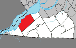 Location within Le Haut-Saint-Laurent RCM | |
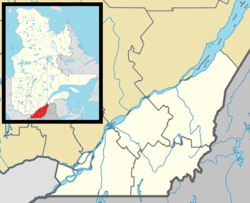  Saint-Anicet Location in southern Quebec | |
| Coordinates: 45°07′N 74°21′W[1] | |
| Country |  Canada Canada |
| Province |  Quebec Quebec |
| Region | Montérégie |
| RCM | Le Haut-Saint-Laurent |
| Constituted | July 1, 1855 |
| Government | |
| • Mayor | Alain Castagner |
| • Federal riding | Beauharnois—Salaberry |
| • Prov. riding | Huntingdon |
| Area | |
| • Total | 180.20 km2 (69.58 sq mi) |
| • Land | 135.33 km2 (52.25 sq mi) |
| Population (2016)[citation needed] | |
| • Total | 2,626 |
| • Density | 19.4/km2 (50/sq mi) |
| • Pop 2011-2016 |  4.1% 4.1% |
| • Dwellings | 2,088 |
| Time zone | UTC−5 (EST) |
| • Summer (DST) | UTC−4 (EDT) |
| Postal code(s) | J0S 1M0 |
| Area code(s) | 450 and 579 |
| Highways |  Route 132 Route 132 |
| Website | www |

Geography
Saint-Anicet is located in the southwestern Montérégie region of Quebec, on the south shore of the Saint Lawrence River.
Communities
The following locations reside within the municipality's boundaries:[1]
- Cazaville (45°05′11″N 74°22′17″W) – a hamlet in the southern portion of the municipality on Route 132.
- Plage-Somerville (45°05′15″N 74°25′31″W) – a hamlet located on Baie de Somerville in the Saint Lawrence River.
- Pointe-Leblanc (45°04′30″N 74°26′26″W) – a hamlet located along the Saint Lawrence River.
- Port Lewis (45°10′14″N 74°16′59″W) – a hamlet located along the Saint Lawrence River on Route 132.
Lakes and rivers
The following waterways pass through or are situated within the municipality's boundaries:[1]
- Rivière La Guerre (45°08′40″N 74°21′03″W) – runs in a southeast to northwest direction to the Saint Lawrence River.
Demographics
Population
| 2021 | 2011 | |
|---|---|---|
| Population | 2,754 (+4.9% from 2016) | 2,523 (-7.1% from 2006) |
| Land area | 135.03 km2 (52.14 sq mi) | 135.16 km2 (52.19 sq mi) |
| Population density | 20.4/km2 (53/sq mi) | 18.7/km2 (48/sq mi) |
| Median age | 55.2 (M: 55.6, F: 55.2) | 51.9 (M: 52.8, F: 50.9) |
| Total private dwellings | 1,310 | 1,965 |
| Median household income | $42,911 |
| Year | Pop. | ±% |
|---|---|---|
| 1991 | 2,215 | — |
| 1996 | 2,549 | +15.1% |
| 2001 | 2,630 | +3.2% |
| 2006 | 2,717 | +3.3% |
| 2011 | 2,523 | −7.1% |
| 2016 | 2,626 | +4.1% |
Language
| Canada Census Mother Tongue Language - Saint-Anicet, Quebec[8] | ||||||||||||||||||
|---|---|---|---|---|---|---|---|---|---|---|---|---|---|---|---|---|---|---|
| Census | Total | French |
English |
French & English |
Other | |||||||||||||
| Year | Responses | Count | Trend | Pop % | Count | Trend | Pop % | Count | Trend | Pop % | Count | Trend | Pop % | |||||
2016 |
2,625 |
2,125 | 4.1% |
80.95% | 395 |  0.0% 0.0% |
15.05% | 50 | 25.0% |
1.90% | 50 | 0.0% |
1.90% | |||||
2011 |
2,525 |
2,040 |  9.3% 9.3% |
80.79% | 395 | 27.4% |
15.64% | 40 | 11.1% |
1.58% | 50 | 54.5% |
1.98% | |||||
2006 |
2,715 |
2,250 | 9.2% |
82.87% | 310 | 12.7% |
11.42% | 45 | 43.8% |
1.66% | 110 | 15.8% |
4.05% | |||||
2001 |
2,590 |
2,060 | 2.7% |
79.54% | 355 | 21.1% |
13.71% | 80 | 166.7% |
3.09% | 95 | 171.4% |
3.67% | |||||
1996 |
2,520 |
2,005 | n/a | 79.56% | 450 | n/a | 17.86% | 30 | n/a | 1.19% | 35 | n/a | 1.39% | |||||
Historic site and museum

In the south of Saint-Anicet, the Tsiionhiakwatha/Droulers archaeological site interpretation center is where an important Iroquoian village in Quebec was located. Circa 1450, approximately 500 St.Lawrence Iroquoians established a village near the La Guerre River. The centre opened on May 15, 2010.[9]
Droulers-Tsiionhiakwatha was designated a Site du patrimoine constitué under provincial legislation in 2005,[10] and a National Historic Site of Canada in 2007.[11]
See also
- Le Haut-Saint-Laurent Regional County Municipality
- La Guerre River
- List of municipalities in Quebec
References
- "Reference number 55616 in Banque de noms de lieux du Québec". toponymie.gouv.qc.ca (in French). Commission de toponymie du Québec.
- Ministère des Affaires municipales, des Régions et de l'Occupation du territoire: Saint-Anicet
- Riding history for Beauharnois—Salaberry, Quebec from the Library of Parliament
- "2011 Community Profiles". 2011 Canadian Census. Statistics Canada. March 21, 2019. Retrieved 2014-02-01.
- "2021 Community Profiles". 2021 Canadian Census. Statistics Canada. February 4, 2022. Retrieved 2022-04-27.
- "2006 Community Profiles". 2006 Canadian Census. Statistics Canada. August 20, 2019.
- "2001 Community Profiles". 2001 Canadian Census. Statistics Canada. July 18, 2021.
- Statistics Canada: 1996, 2001, 2006, 2011 census
- Tsiionhiakwatha/Droulers Archaeological Site Interpretation Centre Archived 2010-06-05 at the Wayback Machine
- Site archéologique Droulers-Tsiionhiakwatha. Canadian Register of Historic Places. Retrieved 24 March 2012.
- Droulers-Tsiionhiakwatha National Historic Site of Canada. Canadian Register of Historic Places. Retrieved 24 March 2012.
External links

- Virtual Museum of Canada, The St. Lawrence Iroquoians — virtual exhibit about the St. Lawrence Iroquoian people, based on the archaeological excavations at the Droulers/Tsiionhiakwatha site.
Adjacent Municipal Subdivisions | ||||||||||||||||
|---|---|---|---|---|---|---|---|---|---|---|---|---|---|---|---|---|
| ||||||||||||||||


| Cities |
|
|---|---|
| Municipalities |
|
| Parishes |
|
| Townships |
|
| |

Authority control | |
|---|---|
| General |
|
| National libraries | |
Другой контент может иметь иную лицензию. Перед использованием материалов сайта WikiSort.org внимательно изучите правила лицензирования конкретных элементов наполнения сайта.
WikiSort.org - проект по пересортировке и дополнению контента Википедии