world.wikisort.org - Canada
Pointe-aux-Outardes is a village municipality in Quebec, Canada, on the southern point of the Manicouagan Peninsula between the mouths of the Outardes and Manicouagan Rivers.
This article may be expanded with text translated from the corresponding article in French. (October 2018) Click [show] for important translation instructions.
|
Pointe-aux-Outardes | |
|---|---|
Village municipality | |
 Pointe-aux-Outardes Location in Côte-Nord region of Quebec. | |
| Coordinates: 49°03′N 68°26′W[1] | |
| Country | |
| Province | |
| Region | Côte-Nord |
| RCM | Manicouagan |
| Constituted | January 1, 1964 |
| Government | |
| • Mayor | André Lepage |
| • Federal riding | Manicouagan |
| • Prov. riding | René-Lévesque |
| Area | |
| • Total | 111.40 km2 (43.01 sq mi) |
| • Land | 74.69 km2 (28.84 sq mi) |
| Population (2011)[3] | |
| • Total | 1,330 |
| • Density | 17.8/km2 (46/sq mi) |
| • Pop 2006-2011 | |
| • Dwellings | 604 |
| Time zone | UTC−5 (EST) |
| • Summer (DST) | UTC−4 (EDT) |
| Postal code(s) | G0H 1M0 |
| Area code(s) | 418 and 581 |
| Highways | |
| Website | www |
The place is named after a piece of land that juts out into the Saint Lawrence River and partially encloses the Outardes Bay: Pointe aux Outardes. It literally means "Point of Bustards", but Outarde can also be translated as "Canada goose".[4] In fact, Canada geese and snow geese use the nearby Manicouagan River as a corridor in their annual migration and stopover at the point. The Innu called it Piletipistu Neshkâu, meaning "point of the Partridge River". But the term Outardes was used on Guérard's map of 1631 and on Franquelin's map of 1685 to identify the river that flows past the point into the St. Lawrence.[1]
Pointe-aux-Outardes is exceptionally rich in flora and fauna. Among its salt marshes, more than 175 species of birds have been counted.[1]
Demographics
In the 2021 Census of Population conducted by Statistics Canada, Pointe-aux-Outardes had a population of 1,434 living in 641 of its 710 total private dwellings, a change of 7.7% from its 2016 population of 1,332. With a land area of 75.19 km2 (29.03 sq mi), it had a population density of 19.1/km2 (49.4/sq mi) in 2021.[5]
Population trend:[6]
- Population in 2011: 1330 (2006 to 2011 population change: -7.8%)
- Population in 2006: 1443
- Population in 2001: 1413
- Population in 1996: 1339
- Population in 1991: 1109
Mother tongue:
- English as first language: 0%
- French as first language: 97.6%
- English and French as first language: 0%
- Other as first language: 2.4%
Photo gallery
 Sunset on Pointe-Aux-Outardes beach
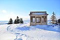 Shelter in Parc nature
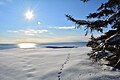 Parc nature in winter


References
- "Pointe-aux-Outardes (Municipalité de village)" (in French). Commission de toponymie du Québec. Retrieved 2010-06-30.
- Ministère des Affaires municipales, des Régions et de l'Occupation du territoire - Répertoire des municipalités: Pointe-aux-Outardes Archived 2012-05-01 at the Wayback Machine
- Statistics Canada 2011 Census - Pointe-aux-Outardes census profile
- Office québécois de la langue française - Le grand dictionnaire terminologique[permanent dead link]
- "Population and dwelling counts: Canada, provinces and territories, and census subdivisions (municipalities), Quebec". Statistics Canada. February 9, 2022. Retrieved August 28, 2022.
- Statistics Canada: 1996, 2001, 2006, 2011 census
Adjacent Municipal Subdivisions | ||||||||||||||||
|---|---|---|---|---|---|---|---|---|---|---|---|---|---|---|---|---|
| ||||||||||||||||
| Cities & Towns |
|
|---|---|
| Municipalities | |
| Parishes | |
| Villages |
|
| Unorganized Territories | |
| Native reserves (Unassociated with RCM) |
|
| |
Другой контент может иметь иную лицензию. Перед использованием материалов сайта WikiSort.org внимательно изучите правила лицензирования конкретных элементов наполнения сайта.
WikiSort.org - проект по пересортировке и дополнению контента Википедии