world.wikisort.org - Canada
Oyama is a neighbourhood and formal ward located within the district municipality of Lake Country, which is located in the Okanagan region in British Columbia, Canada. It is located at the north end of Wood Lake and at the south end of Kalamalka Lake opposite BC Highway 97.[1]
Oyama | |
|---|---|
neighbourhood | |
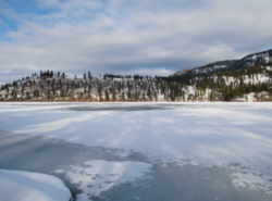 Looking across frozen Kalamalka Lake from Kaloya Regional Park | |
| Coordinates: 50°07′00″N 119°22′00″W | |
| Country | |
| Province | |
| Regional district | Central Okanagan |
| District | Lake Country |
| Population | 985 |
Name origin
Oyama is named after Japanese Field Marshal Ōyama Iwao in 1906 by the first post master Dr. W. H. Irvine.[2][3]: 200a
Climate
| Climate data for Oyama | |||||||||||||
|---|---|---|---|---|---|---|---|---|---|---|---|---|---|
| Month | Jan | Feb | Mar | Apr | May | Jun | Jul | Aug | Sep | Oct | Nov | Dec | Year |
| Record high °C (°F) | 16 (61) |
15 (59) |
21 (70) |
27.8 (82.0) |
33 (91) |
36.5 (97.7) |
39 (102) |
37 (99) |
32.5 (90.5) |
27.5 (81.5) |
20 (68) |
13.5 (56.3) |
39 (102) |
| Average high °C (°F) | 0.6 (33.1) |
2.8 (37.0) |
9.6 (49.3) |
14.7 (58.5) |
19.8 (67.6) |
23.3 (73.9) |
26.3 (79.3) |
26.6 (79.9) |
20.4 (68.7) |
12.6 (54.7) |
4.8 (40.6) |
0 (32) |
13.5 (56.2) |
| Daily mean °C (°F) | −1.9 (28.6) |
−0.6 (30.9) |
4.5 (40.1) |
8.9 (48.0) |
13.4 (56.1) |
17.1 (62.8) |
19.4 (66.9) |
19.7 (67.5) |
14.4 (57.9) |
8.2 (46.8) |
2 (36) |
−2.3 (27.9) |
8.6 (47.5) |
| Average low °C (°F) | −4.4 (24.1) |
−3.9 (25.0) |
−0.6 (30.9) |
3.1 (37.6) |
6.9 (44.4) |
10.9 (51.6) |
12.5 (54.5) |
12.8 (55.0) |
8.3 (46.9) |
3.8 (38.8) |
−0.9 (30.4) |
−4.6 (23.7) |
3.7 (38.7) |
| Record low °C (°F) | −25.5 (−13.9) |
−23 (−9) |
−19.4 (−2.9) |
−5 (23) |
−2 (28) |
0.6 (33.1) |
3.9 (39.0) |
3.5 (38.3) |
−2.5 (27.5) |
−16 (3) |
−27.5 (−17.5) |
−26.5 (−15.7) |
−27.5 (−17.5) |
| Average precipitation mm (inches) | 41.1 (1.62) |
32 (1.3) |
32.3 (1.27) |
37.6 (1.48) |
48 (1.9) |
54.1 (2.13) |
50.7 (2.00) |
34.5 (1.36) |
43.2 (1.70) |
36.4 (1.43) |
53.6 (2.11) |
51.9 (2.04) |
515.2 (20.28) |
| Average rainfall mm (inches) | 12.6 (0.50) |
18 (0.7) |
27.7 (1.09) |
37.6 (1.48) |
48 (1.9) |
54.1 (2.13) |
50.7 (2.00) |
34.5 (1.36) |
43.2 (1.70) |
35.9 (1.41) |
36.1 (1.42) |
12.6 (0.50) |
411 (16.2) |
| Average snowfall cm (inches) | 28.5 (11.2) |
14 (5.5) |
4.5 (1.8) |
0 (0) |
0 (0) |
0 (0) |
0 (0) |
0 (0) |
0 (0) |
0.5 (0.2) |
17.5 (6.9) |
39.3 (15.5) |
104.2 (41.0) |
| Source: [4] | |||||||||||||
Education
It is home to Oyama Traditional School, a public elementary school that is part of the School District 23 Central Okanagan, which is based in Kelowna.[5]
References
Wikimedia Commons has media related to Oyama, British Columbia.
- BC Names entry "Oyama (community)"
- "Oyama". Lake Country Museum.
- Akrigg, G.P.V.; Akrigg, Helen B. (1986), British Columbia Place Names (3rd, 1997 ed.), Vancouver: UBC Press, ISBN 0-7748-0636-2
- "Calculation Information for 1981 to 2010 Canadian Normals Data". Environment Canada. Archived from the original on June 14, 2013. Retrieved July 9, 2013.
- "School Directory". School District 23 Central Okanagan. Retrieved December 5, 2012.
Subdivisions of British Columbia | |
|---|---|
| Subdivisions |
|
| Communities |
|
| Metro areas and agglomerations |
|
| Detached communities within district municipalities |
|
| |
Municipalities and communities of Okanagan, British Columbia, Canada | ||
|---|---|---|
| Cities |  | |
| Towns | ||
| Districts |
| |
| Villages | ||
| Designated places |
| |
| Unincorporated communities |
| |
| Indian reserves |
| |
| Ghost towns | ||
| Footnotes | ‡This populated place also has portions in an adjacent region | |
На других языках
- [en] Oyama, British Columbia
[ru] Ояма (Британская Колумбия)
Ояма — село расположенное в регионе Оканаган в Британской Колумбии, Канада. Расположено на северной окраине Лесного озера и южной оконечности озера Каламалка. Название села дано по имени японского генерала русско-японской войны, принца Оямы Ивао, награждённого в 1906 году орденом почётного члена британского Ордена Заслуг[1].Текст в блоке "Читать" взят с сайта "Википедия" и доступен по лицензии Creative Commons Attribution-ShareAlike; в отдельных случаях могут действовать дополнительные условия.
Другой контент может иметь иную лицензию. Перед использованием материалов сайта WikiSort.org внимательно изучите правила лицензирования конкретных элементов наполнения сайта.
Другой контент может иметь иную лицензию. Перед использованием материалов сайта WikiSort.org внимательно изучите правила лицензирования конкретных элементов наполнения сайта.
2019-2026
WikiSort.org - проект по пересортировке и дополнению контента Википедии
WikiSort.org - проект по пересортировке и дополнению контента Википедии