world.wikisort.org - Canada
Lac-Beauport is a town in the Capitale-Nationale region of Quebec, Canada, located on the eponymous Lake Beauport. It has a population of about 8,200 people, and lies about 25 kilometres north from downtown Quebec City. Lac-Beauport is the home of Le Relais ski centre.
Lac-Beauport | |
|---|---|
Municipality | |
 Lake Beauport | |
 Location within La Jacques-Cartier RCM. | |
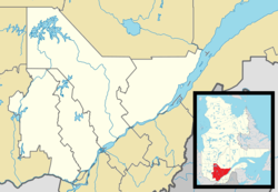  Lac-Beauport Location in central Quebec. | |
| Coordinates: 46°58′N 71°18′W[1] | |
| Country |  Canada Canada |
| Province |  Quebec Quebec |
| Region | Capitale-Nationale |
| RCM | La Jacques-Cartier |
| Settled | 1820 |
| Constituted | July 1, 1855 |
| Government | |
| • Mayor | Charles Brochu |
| • Federal riding | Portneuf—Jacques-Cartier |
| • Prov. riding | Chauveau |
| Area | |
| • Total | 64.00 km2 (24.71 sq mi) |
| • Land | 61.73 km2 (23.83 sq mi) |
| Population (2021)[3] | |
| • Total | 8,164 |
| • Density | 132.2/km2 (342/sq mi) |
| • Pop 2016-2021 |  4.7% 4.7% |
| • Dwellings | 3,201 |
| Time zone | UTC−5 (EST) |
| • Summer (DST) | UTC−4 (EDT) |
| Postal code(s) | G3B 0A1 |
| Area code(s) | 418 and 581 |
| Highways | No major routes |
| Website | www |
Geography
The municipality of Lac-Beauport surrounds the homonymous lake. It is bounded to the south by Quebec City, to the north and west by the united townships of Stoneham-et-Tewkesbury and to the east by the municipality of Sainte-Brigitte-de-Laval. Located in the Laurentians massif, the municipality occupies the basin centered on the lake as well as the surrounding hills and mountains.
History
Around 1820, a small cluster of homes was built on the present site of the municipality, named Waterloo Settlement by the English immigrants after the Anglo-Prussian victory at Waterloo. In 1845, the Municipality of St-Dunstan was formed, named after the local parish of Saint-Dunstan-du-Lac-Beauport. It was abolished in 1847, but reestablished as the Parish Municipality of Saint-Dunstan-du-Lac-Beauport in 1855. In common use, it was only known as Lac-Beauport, prompting the town council to officially change the name in 1989.[1]
Demographics
Population
|
|
|
| 2021 | 2016 | 2011 | |
|---|---|---|---|
| Population | 8,164 (+4.7% from 2016) | 7,801 (+6.5% from 2011) | 7,281 (+19.7% from 2006) |
| Land area | 61.73 km2 (23.83 sq mi) | 61.79 km2 (23.86 sq mi) | 61.27 km2 (23.66 sq mi) |
| Population density | 132.2/km2 (342/sq mi) | 126.2/km2 (327/sq mi) | 118.8/km2 (308/sq mi) |
| Median age | 42.4 (M: 43.2, F: 42) | 41 (M: 41.7, F: 40.3) | 38.6 (M: 39.3, F: 37.9) |
| Total private dwellings | 3,201 | 3,031 | 2,815 |
| Median household income | $134,000 | $116,832 | $102,376 |
Language
Mother tongue:
- English as first language: 2.3%
- French as first language: 95.5%
- English and French as first language: 1%
- Other as first language: 1%

See also
- List of municipalities in Quebec
References
- "Lac-Beauport (Municipalité)" (in French). Commission de toponymie du Québec. Retrieved 2010-04-20.
- Ministère des Affaires municipales, des Régions et de l'Occupation du territoire - Répertoire des municipalités: Lac-Beauport Archived 2014-04-07 at the Wayback Machine
- Statistics Canada 2021 Census - Lac-Beauport census profile
- Statistics Canada: 1996, 2001, 2006, 2011, 2016, 2021 census
- "2016 Community Profiles". 2016 Canadian Census. Statistics Canada. August 12, 2021. Retrieved 2022-10-21.
- "2011 Community Profiles". 2011 Canadian Census. Statistics Canada. March 21, 2019. Retrieved 2022-10-21.
- "2006 Community Profiles". 2006 Canadian Census. Statistics Canada. August 20, 2019.
- "2001 Community Profiles". 2001 Canadian Census. Statistics Canada. July 18, 2021.
External links
 Media related to Lac-Beauport at Wikimedia Commons
Adjacent Municipal Subdivisions | ||||||||||||||||
|---|---|---|---|---|---|---|---|---|---|---|---|---|---|---|---|---|
| ||||||||||||||||


| Cities & towns |
|
|---|---|
| Municipalities | |
| United Townships | |
| Unorganized territories | |
| |

Authority control | |
|---|---|
| General | |
| National libraries | |
| Other |
|

На других языках
[de] Lac-Beauport
Lac-Beauport ist eine Gemeinde im Süden der kanadischen Provinz Québec. Sie liegt in der Verwaltungsregion Capitale-Nationale, etwa 20 km nördlich des Zentrums der Provinzhauptstadt Québec. Lac-Beauport gehört zur regionalen Grafschaftsgemeinde (municipalité régionale du comté) La Jacques-Cartier, hat eine Fläche von 61,79 km² und zählt 7801 Einwohner (Stand: 2016).- [en] Lac-Beauport, Quebec
Другой контент может иметь иную лицензию. Перед использованием материалов сайта WikiSort.org внимательно изучите правила лицензирования конкретных элементов наполнения сайта.
WikiSort.org - проект по пересортировке и дополнению контента Википедии