world.wikisort.org - Canada
Colborne is a civil parish in Restigouche County, New Brunswick, Canada.[2]
Colborne | |
|---|---|
Parish | |
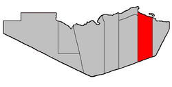 Location within Restigouche County. Heron Island erroneously shown as part of Durham Parish. | |
| Coordinates: 47.8875°N 66.27°W | |
| Country | |
| Province | |
| County | Restigouche |
| Erected | 1840 |
| Area | |
| • Land | 753.38 km2 (290.88 sq mi) |
| Population (2021)[1] | |
| • Total | 266 |
| • Density | 0.4/km2 (1/sq mi) |
| • Change 2016-2021 | |
| • Dwellings | 162 |
| Time zone | UTC-4 (AST) |
| • Summer (DST) | UTC-3 (ADT) |
| Figures do not include portion within the village of Charlo | |
For governance purposes it is divided between the village of Charlo, the Indian reserve of Moose Meadows 4, and the local service districts of Chaleur and Lorne,[3] all of which except the Indian reserve are members of the Restigouche Regional Service Commission (RRSC).[4]
Origin of name
The parish was named in honour of John Colborne, acting Governor General of the Canadas when the parish was erected.[5]
History
Colborne was erected in 1840 from Addington and Beresford Parishes.[6] Colborne comprised Restigouche County between the Benjamin and Eel Rivers.
In 1850 the boundaries were altered to run due south from starting points near the coast: the western boundary from milepost forty-eight on the great road (highway) from Bathurst to Dalhousie, the eastern boundary from the mouth of the Benjamin River.[7]
Boundaries
Colborne Parish is bounded:[2][8][9]
- on the north by Chaleur Bay;
- on the east by a line running true south from the mouth of Benjamin River to the Northumberland County line;
- on the south by the county line;
- on the west by a line running true south from a point near the northern end of the Eel River Bar Seawall to the county line
- including Heron Island and any islands in front of the parish.
Communities
Communities at least partly within the parish.[8][9][10] bold indicates an incorporated municipality or Indian reserve
- Benjamin River
- Blackland
- Caribou Depot
- Lorne
- Moose Meadows 4
- New Mills
- Upper Crossing
- Charlo
- Mountain Brook
- River Charlo
- Upper Charlo
Bodies of water
Bodies of water[lower-alpha 1] at least partly within the parish.[8][9][10]
- Benjamin River
- North Branch Charlo River
- Jacquet River
- Louison River
- South Charlo River
- Southeast Upsalquitch River
- Tetagouche River
- Harrys Bogan
- Nash Creek
- Chaleur Bay
- Heron Channel
- Shoal Bay
- at least ten officially named lakes
Islands
Islands at least partly within the parish.[8][9][10]
- Fleming Island
- Heron Island
- West Point Island
- Thrum Rock
Other notable places
Parks, historic sites, and other noteworthy places at least partly within the parish.[8][9][10]
- Chaleur Provincial Park
- Charlo Regional Airport
- Eel River Bar Seawall
- Key Anacon Mine
Demographics
Parish population total does not include Moose Meadows 4 Indian reserve or portion within Charlo
Population
| 2021 | 2016 | 2011 | |
|---|---|---|---|
| Population | 266 (+17.2% from 2016) | 227 (+12.4% from 2011) | 202 (-13.7% from 2006) |
| Land area | 753.38 km2 (290.88 sq mi) | 754.96 km2 (291.49 sq mi) | 754.95 km2 (291.49 sq mi) |
| Population density | 0.4/km2 (1.0/sq mi) | 0.3/km2 (0.78/sq mi) | 0.3/km2 (0.78/sq mi) |
| Median age | 58.8 (M: 59.2, F: 58) | 55.8 (M: 55.8, F: 55.7) | 50.5 (M: 49.3, F: 53.8) |
| Total private dwellings | 135 | 144 | 102 |
| Median household income | $39,808 | $.N/A |
|
|
| |||||||||||||||||||||||||||
| [16][17] | |||||||||||||||||||||||||||||
Language
| Canada Census Mother Tongue - Colborne Parish, New Brunswick[16] | ||||||||||||||||||
|---|---|---|---|---|---|---|---|---|---|---|---|---|---|---|---|---|---|---|
| Census | Total | English |
French |
English & French |
Other | |||||||||||||
| Year | Responses | Count | Trend | Pop % | Count | Trend | Pop % | Count | Trend | Pop % | Count | Trend | Pop % | |||||
2011 |
200 |
160 | 80.00% | 35 | 17.50% | 0 | 0.00% | 5 | 2.50% | |||||||||
2006 |
235 |
200 | 85.11% | 15 | 6.38% | 20 | 8.51% | 0 | 0.00% | |||||||||
2001 |
275 |
250 | 90.91% | 25 | 9.09% | 0 | 0.00% | 0 | 0.00% | |||||||||
1996 |
250 |
205 | n/a | 82.00% | 45 | n/a | 18.00% | 0 | n/a | 0.00% | 0 | n/a | 0.00% | |||||
Access Routes
Highways and numbered routes that run through the parish, including external routes that start or finish at the parish limits:[18]
|
|
|
|
See also
- List of parishes in New Brunswick
Notes
- Not including brooks, ponds or coves.
References
- "Census Profile". Statistics Canada. 26 October 2022. Retrieved 29 October 2022.
- "Chapter T-3 Territorial Division Act". Government of New Brunswick. Retrieved 13 November 2020.
- "New Brunswick Regulation 84-168 under the Municipalities Act (O.C. 84-582)". Government of New Brunswick. Retrieved 22 July 2020.
- "Communities in each of the 12 Regional Service Commissions (RSC) / Les communautés dans chacune des 12 Commissions de services régionaux (CSR)" (PDF), Government of New Brunswick, July 2017, retrieved 2 February 2021
- Ganong, William F. (1896). A Monograph of the Place-Nomenclature of the Province of New Brunswick. Royal Society of Canada. p. 227. Retrieved 17 March 2021.
- "2 Vic. c. 19 An Act to divide the County of Restigouche into five Towns or Parishes and to define the boundaries thereof.". Acts of the General Assembly of Her Majesty's Province of New Brunswick, Passed in the Year 1839. Fredericton: Government of New Brunswick. 1839. pp. 63–64. Retrieved 27 March 2021.
- "13 Vic. c. 51 An Act to consolidate all the Laws now in force for the division of the Province into Counties, Towns and Parishes.". Acts of the General Assembly of Her Mjaesty's Province of New Brunswick, Passed in the Year 1850. Fredericton: Government of New Brunswick. 1850. pp. 142–152, 145–149. Retrieved 27 March 2021. Book was poorly proofread, resulting in title typo and reuse of page numbers 145–152.
- "No. 6". Provincial Archives of New Brunswick. Department of Natural Resources and Energy Development. Retrieved 20 June 2021. Remainder of parish on maps 7, 14, 15, and 26 at same site.
- "003" (PDF). Transportation and Infrastructure. Government of New Brunswick. Retrieved 20 June 2021. Remainder of parish on mapbooks 004, 015, 016, 029, 030, 048, 049, 068, 069, 088, and 089 at same site.
- "Search the Canadian Geographical Names Database (CGNDB)". Government of Canada. Retrieved 6 July 2021.
- "2021 Community Profiles". 2021 Canadian Census. Statistics Canada. 4 February 2022. Retrieved 27 April 2022.
- "2016 Community Profiles". 2016 Canadian Census. Statistics Canada. 12 August 2021. Retrieved 26 August 2019.
- "2011 Community Profiles". 2011 Canadian Census. Statistics Canada. 21 March 2019. Retrieved 16 March 2014.
- "2006 Community Profiles". 2006 Canadian Census. Statistics Canada. 20 August 2019.
- "2001 Community Profiles". 2001 Canadian Census. Statistics Canada. 18 July 2021.
- Statistics Canada: 1996, 2001, 2006, 2011 census
- "Census Profile, 2016 Census: Colborne Parish, New Brunswick". Statistics Canada. Retrieved 26 August 2019.
- Atlantic Canada Back Road Atlas ISBN 978-1-55368-618-7 Pages 6, 14-15
Places adjacent to Colborne Parish, New Brunswick | |
|---|---|
Subdivisions of New Brunswick | |
|---|---|
| Subdivisions |
|
| Cities | |
| Counties | |
| |
Другой контент может иметь иную лицензию. Перед использованием материалов сайта WikiSort.org внимательно изучите правила лицензирования конкретных элементов наполнения сайта.
WikiSort.org - проект по пересортировке и дополнению контента Википедии