world.wikisort.org - Canada
Bathurst is a civil parish in Gloucester County, New Brunswick, Canada.[2] The population is concentrated in the northeastern corner of the parish.
Bathurst | |
|---|---|
Parish | |
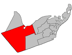 Location within Gloucester County, New Brunswick | |
| Coordinates: 47.46°N 65.86°W | |
| Country | |
| Province | |
| County | Gloucester |
| Erected | 1827 |
| Area | |
| • Land | 1,502.74 km2 (580.21 sq mi) |
| Population (2021)[1] | |
| • Total | 4,761 |
| • Density | 3.2/km2 (8/sq mi) |
| • Change 2016-2021 | |
| • Dwellings | 2,293 |
| Time zone | UTC-4 (AST) |
| • Summer (DST) | UTC-3 (ADT) |
| Figures do not include portions within the city of Bathurst, the town of Beresford, and the Pabineau 11 Indian reserve | |
One city, three local service districts (LSDs), and one Indian reserve are entirely within the parish, along with parts of one town and three LSDs; except the Indian reserve, all are members of the Chaleur Regional Service Commission (CRSC).[3]
Origin of name
The parish was named in honour of Earl Bathurst, British Secretary of State for War and the Colonies at the time of its erection.[4]
History
Bathurst was erected in 1827 from the western part of Saumarez Parish.[5] Its eastern boundary followed Teagues Brook to its head and ran south "to the county line", which it doesn't actually reach.
In 1850 the eastern boundary was altered to match the northern end of the modern parish line then along its prolongation to the county line, trading areas with New Bandon Parish.[6]
In 1947 a large area in the southeastern part of the parish was included in the newly erected Allardville Parish.[7]
Boundaries
Bathurst Parish is bounded:[2][8][9]
- on the north by Nepisiguit Bay;
- on the east by a grant line that crosses the junction of Route 11 and Route 340 near Janeville, then southerly by the line and its prolongation to Tier 1 of the Allardville East Settlement, which runs along the northern side of Route 160, then briefly westerly along Tier 1 to the prolongation of the boundary of the Tracadie River Game Management area, at a right angle and northerly along the boundary of the GMA, then at a right angle and westerly along the prolongation of the southern line of two grants south of Goodwin Mills Road to the Canadian National Railway line, then southerly along the railway to the Northumberland County line;
- on the south by the county line;
- on the northwest by the prolongation of the northern lines of two grants on the north side of Kent Lodge Road in Beresford from Nepisiguit Bay to the county line;
- the parish also includes any islands in front of it.
Governance
The LSDs all assess for community & recreation services; all except New Bandon-Salmon Beach also have street lighting.
- Bathurst is located around Bathurst Harbour and contains most of the population. Population in 2016 was 11,897.[10]
- Beresford extends into the parish on the northwestern corner of Bathurst, between the railway and the coast. No separate population figure for Bathurst Parish portion.
- Pabineau 11 Indian reserve straddles the Nepisiguit River at the mouth of the Pabineau River. Population in 2016 was 134.[10]
- Big River extends inland from the southern edge of Bathurst, along Route 340 past the Pabineau reserve, and along the Little River Road. It was established in 1989 to add street lighting.[11] Population in 2016 was 721.[12]
- North Tetagouche sits between the Beresford Parish line and the Tetagouche River from Bathurst to the end of North Tetagouche Road, excluding a small area that's included in Dunlop. It was established in 1987 to provide community services.[13] Population in 2016 was 945.[12]
- Allardville, mainly in Allardville Parish, includes about 200 hectares along Route 134, south of Goodwin Mill Road. 2016 population not profiled for this portion.
- Dunlop, mainly in Beresford Parish, extends into the parish about a half kilometre along Route 315. 2016 population not profiled for this portion.
- New Bandon-Salmon Beach, partly in New Bandon Parish, includes all of the parish east of Bathurst and the rear line of the tier of grants along Route 134. Population of the Bathurst Parish portion in 2016 was 354.[12]
- The local service district of the parish of Bathurst comprises the remainder of the parish. It was established in 1969[14] and originally included all of the parish outside Bathurst and Beresford. Several service areas were formerly defined to provide street lighting but were deleted in 2008[15] after residents of the remainder of the LSD voted to add street lighting;[16] These were sometimes erroneously called LSDs.
- Poirier Subdivision, established 1985.[17] A subdivision off Route 134 near the southern border of Bathurst.
- Lone Pine and Napier Heights, established 1987.[18] A subdivision area on the south bank of the Tetagouche River, near the western boundary of Bathurst.
- Sainte-Anne, established 1990.[19] On the western border of Bathurst, from the Tetagouche River to Sainte-Anne Road south of Power Drive.
- Tetagouche Falls Estates, established 1990.[20] Subdivision off Route 180, including Apple Street and Birch Drive.
- Rough Waters-Gloucester Junction-Chamberlain Settlement, established 1990.[21] On southern border of Bathurst, along Chamberlain Settlement Road and Gloucester Junction Road.
- Middle River-Rio Grande, established 1995.[22] On the southwestern border of Bathurst and extending along Thériault Road and Rio Grande Road.
Governance reform
A 2021 white paper recommended a major reform of the province's governance entities; these changes are scheduled to take effect in 2023 but are not yet finalised. Bathurst Parish would be affected by the following changes:[23][24]
- Beresford and Dunlop will be part of Local government entity 11.
- Bathurst will form Local government entity 12, along with North Tetagouche, 40% of the population of Big River, and 68% of the LSD of the parish of Bathurst.
- Allardville, New Bandon-Salmon Beach, and the remainder of Big River and the LSD of the parish of Bathurst will become part of the Rural district for the Chaleur RSC.
Communities
Communities at least partly within the parish;[8][9][25][26] (brackets) indicate the LSD; italics indicate a name not used on modern provincial government maps
- Allardville (A) straddles the parish line along Route 134
- Bathurst
- Bass River, Carron Point, Cross Roads, East Bathurst, Rough Waters, Roy Settlement, St. Mary, Sand Hill, South Bathurst, Vallée-Lourdes, West Bathurst, Youghall
- Bathurst Mines (B) is about 20 km south-southwest of Bathurst, on the Nepisiguit River
- Beresford straddles the parish line on the northwestern corner of Bathurst
- Big River (BR) is along Route 430 on the southern border of Bathurst
- Blue Mountain Settlement (BR) is along Route 430, north of the Pabineau 11 reserve
- Brunswick Mines (B) is about 15 km southwest of Bathurst, on the South Branch Little River
- Chamberlain Settlement (B) is south of Bathurst, east of the Nepisiguit River
- Glen Anglin (NBSB) is now part of Janeville
- Gloucester Junction (B) is along the Gloucester Junction Road, south of Chamberlain Settlement
- Goodwin Mill (B) is along Goodwin Mill Road, north of Allardville
- Janeville (NBSB) is on Chaleur Bay, straddling the eastern parish line
- Middle Landing (B) is inland where Route 360 crosses the Nepisiguit River
- Miller Brook is now part of Salmon Beach
- Nepisiguit Junction (BR) is at the junction of Route 430 and the CN railway
- North Tetagouche (NT)
- Pabineau 11
- Pabineau Falls (BR) is north of the Indian reserve[lower-alpha 1]
- Rio Grande (B) is west of Bathurst
- Rosehill is now part of South Tetagouche
- Sainte-Anne (B) is on the western border of Bathurst
- Salmon Beach (NBSB) in on Chaleur Bay, on eastern border of Bathurst
- South Tetagouche (B)
- Upper Rosehill was along Daigle Road, now part of South Tetagouche
- railway points along the eastern edge of the parish: Bartibog Station, Bruce Siding, Red Pine, Russell
Bodies of water
Bodies of water[lower-alpha 2] at least partly within the parish.[8][9][25]
- Bass River
- Big Tracadie River
- Little River
- Little Bass River
- Middle River
- Nepisiguit River
- Pabineau River
- Peters River
- Portage River
- Tetagouche River
- Bathurst Basin
- Bathurst Harbour
- Nepisiguit Bay
- at least 8 officially named lakes
Islands
Islands at least partly within the parish.[8][9][25]
- Indian Island (in Bathurst Harbour)
- Pabineau Island
- Sipisgoatagantjitjg (group of islets in Bathurst Harbour)
- at least 7 other named river islands
Other notable places
Parks, historic sites, and other noteworthy places at least partly within the parish.[8][9][25][27]
- Allardville Protected Natural Area
- Bass Brook Protected Natural Area
- Bathurst Mines
- Bathurst Regional Airport
- Brunswick Mines
- East Branch Portage River Protected Natural Area
- Gordon Meadow Brook Protected Natural Area
- Key Anacon Mine
- Tracadie River Wildlife Management Area[28]
Demographics
Population
Parish population total does not include municipalities or Indian reserve
| 2021 | 2016 | 2011 | |
|---|---|---|---|
| Population | 4,761 (-0.8% from 2016) | 4,797 (-3.7% from 2011) | 4,979 (-3.2% from 2006) |
| Land area | 1,502.74 km2 (580.21 sq mi) | 1,504.87 km2 (581.03 sq mi) | 1,504.80 km2 (581.01 sq mi) |
| Population density | 3.2/km2 (8.3/sq mi) | 3.2/km2 (8.3/sq mi) | 3.3/km2 (8.5/sq mi) |
| Median age | 52.4 (M: 52.8, F: 52) | 50.1 (M: 50.1, F: 50.1) | 47.1 (M: 47.7, F: 46.7) |
| Total private dwellings | 2,105 | 2,292 | 2,223 |
| Median household income | $64,597 | $54,540 |
|
|
| |||||||||||||||||||||||||||
| [34][35] | |||||||||||||||||||||||||||||
Language
| Canada Census Mother Tongue – Bathurst Parish, New Brunswick[34] | ||||||||||||||||||
|---|---|---|---|---|---|---|---|---|---|---|---|---|---|---|---|---|---|---|
| Census | Total | French |
English |
French & English |
Other | |||||||||||||
| Year | Responses | Count | Trend | Pop % | Count | Trend | Pop % | Count | Trend | Pop % | Count | Trend | Pop % | |||||
2011 |
4,965 |
2,435 | 49.04% | 2,395 | 48.24% | 105 | 2.11% | 30 | 0.60% | |||||||||
2006 |
5,130 |
2,325 | 45.32% | 2,660 | 51.85% | 75 | 1.46% | 70 | 1.36% | |||||||||
2001 |
5,485 |
2,710 | 49.41% | 2,630 | 47.95% | 115 | 2.10% | 30 | 0.55% | |||||||||
1996 |
5,775 |
3,035 | n/a | 52.55% | 2,600 | n/a | 45.02% | 130 | n/a | 2.25% | 10 | n/a | 0.17% | |||||
See also
- List of parishes in New Brunswick
Notes
- The provincial 911 system lists it separately from the reserve.
- Not including brooks, ponds or coves.
References
- "Census Profile". Statistics Canada. 26 October 2022. Retrieved 29 October 2022.
- "Chapter T-3 Territorial Division Act". Government of New Brunswick. Retrieved 13 November 2020.
- "Communities in each of the 12 Regional Service Commissions (RSC) / Les communautés dans chacune des 12 Commissions de services régionaux (CSR)" (PDF), Government of New Brunswick, July 2017, retrieved 2 February 2021
- Ganong, William F. (1896). A Monograph of the Place-Nomenclature of the Province of New Brunswick. Royal Society of Canada. p. 219. Retrieved 17 March 2021.
- "7 Geo. IV c. 31 An Act for the division of the County of Northumberland into three Counties, and to provide for the Government and Representation of the two new Counties.". Acts of the General Assembly of His Majesty's Province of New-Brunswick, Passed in the Year 1827. Fredericton: Government of New Brunswick. 1827. pp. 97–103. Retrieved 27 March 2021.
- "13 Vic. c. 51 An Act to consolidate all the Laws now in force for the division of the Province into Counties, Towns and Parishes.". Acts of the General Assembly of Her Mjaesty's Province of New Brunswick, Passed in the Year 1850. Fredericton: Government of New Brunswick. 1850. pp. 142–152, 145–149. Retrieved 27 March 2021. Book was poorly proofread, resulting in title typo and reuse of page numbers 145–152.
- "10 Geo. VI. c. 90 An Act to amend the Act respecting the division of the Province into Counties, Towns and Parishes, in so far as it relates to the County of Gloucester". Acts of the Legislative Assembly of New Brunswick Passed During the Session of 1946. Fredericton: Government of New Brunswick. 1946. pp. 301–309.
- "No. 16". Provincial Archives of New Brunswick. Department of Natural Resources and Energy Development. Retrieved 8 June 2021. Remainder of parish on maps 17, 26, 27, 28, 29, 40, 41, 50, and 51 at same site.
- "069" (PDF). Transportation and Infrastructure. Government of New Brunswick. Retrieved 8 June 2021. Remainder of parish on mapbooks 070–072, 088–093, 109–111, 131–133, 154, and 155 at same site.
- "Population and dwelling counts, for Canada, provinces and territories, and census subdivisions (municipalities), 2016 and 2011 censuses – 100% data". Statistics Canada. 7 February 2018. Retrieved 19 December 2021.
- New Brunswick Regulation 89-195 under the Municipalities Act
- "Population and dwelling counts, for Canada, provinces and territories, and designated places, 2016 and 2011 censuses – 100% data". Statistics Canada. Retrieved 13 December 2021.
- "Regulation 87-42 under the Municipalities Act (O.C. 87-278)". The Royal Gazette. Fredericton: The Queen's Printer. 145: 547–564. 6 May 1987.
- "Regulation 69–95 under the Municipalities Act (O. C. 69–986)". The Royal Gazette. Fredericton. 127: 599. 8 October 1969.
- "Regulation 2008-156 under the Municipalities Act (O. C. 2008-552)" (PDF). The Royal Gazette. Fredericton. 167: 95. 14 January 2009. ISSN 1714-9428.
- Mallory, James (9 September 2008). "LSD residents vote in favour of street lights". The Northern Light. Bathurst, New Brunswick. p. A5.
- Regulation 85-103 under the Municipalities Act
- New Brunswick Regulation 87-104 under the Municipalities Act
- Regulation 90-66 under the Municipalities Act.
- Regulation 90-133 under the Municipalities Act.
- Regulation 90-176 under the Municipalities Act.
- Regulation 95-79 under the Municipalities Act.
- Working together for vibrant and sustainable communities (PDF) (Report). Government of New Brunswick. November 2021. pp. 42–43. ISBN 978-1-4605-2959-1. Retrieved 12 December 2021.
- "untitled list of adjustments" (PDF). Government of New Brunswick. 21 December 2021. Retrieved 23 December 2021.
- "Search the Canadian Geographical Names Database (CGNDB)". Government of Canada. Retrieved 6 July 2021.
- "GeoNB Map Viewer". Government of New Brunswick. Retrieved 24 December 2021.
- "Explore New Brunswick's Protected Natural Areas". GeoNB. Retrieved 2 July 2021.
- "New Brunswick Regulation 94-43 under the Fish and Wildlife Act (O.C. 94-231)". Government of New Brunswick. 5 June 2006. Retrieved 8 July 2021.
- "2021 Community Profiles". 2021 Canadian Census. Statistics Canada. 4 February 2022. Retrieved 27 April 2022.
- "2016 Community Profiles". 2016 Canadian Census. Statistics Canada. 12 August 2021. Retrieved 9 September 2019.
- "2011 Community Profiles". 2011 Canadian Census. Statistics Canada. 21 March 2019. Retrieved 6 April 2014.
- "2006 Community Profiles". 2006 Canadian Census. Statistics Canada. 20 August 2019.
- "2001 Community Profiles". 2001 Canadian Census. Statistics Canada. 18 July 2021.
- Statistics Canada: 1996, 2001, 2006, 2011 census
- "Census Profile, 2016 Census: Bathurst, Parish [Census subdivision], New Brunswick". Statistics Canada. Retrieved 9 September 2019.
Places adjacent to Bathurst Parish, New Brunswick | |
|---|---|
Subdivisions of New Brunswick | |
|---|---|
| Subdivisions |
|
| Cities | |
| Counties | |
| |
Другой контент может иметь иную лицензию. Перед использованием материалов сайта WikiSort.org внимательно изучите правила лицензирования конкретных элементов наполнения сайта.
WikiSort.org - проект по пересортировке и дополнению контента Википедии