world.wikisort.org - Canada
Assiniboia is a town in the Canadian province of Saskatchewan. It is located 110 km (68 mi) south-southwest of Moose Jaw beside Highway 2 and Highway 13.
Assiniboia | |
|---|---|
Town | |
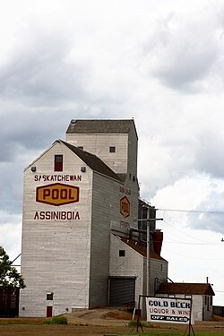
 Assiniboia Grain Elevator | |
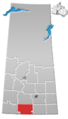
 Assiniboia Location of Assiniboia  Assiniboia Assiniboia (Saskatchewan) | |
| Coordinates: 49.6328°N 105.9921°W | |
| Country | Canada |
| Province | Saskatchewan |
| Federal Electoral District | Cypress Hills-Grasslands |
| Provincial Constituency | Wood River |
| Village | 22 December 1912 |
| Town | 1913 |
| Government | |
| • Mayor | Sharon Schauenberg |
| • MLA | Dave Marit |
| • MP | Jeremy Patzer |
| Area | |
| • Land | 3.79 km2 (1.46 sq mi) |
| Population (2016) | |
| • Total | 2,389 |
| • Density | 243.4/km2 (630.3/sq mi) |
| Demonym(s) | Assiniboian |
| Time zone | UTC−06:00 (CST) |
| Website | Town of Assiniboia |
| [1] | |
History
The Dominion Land Survey's description of the area around Assiniboia is Sec.18, Twp.8, R.29, W2. It was first settled by people of English, French, Romanian, Scottish, and Scandinavian descent.[2] From 30 March 1908 to 23 November 1912, the post office at this location was named Leeville, Saskatchewan.[3]
The settlement of Assiniboia originated on 12 October 1912, when the Canadian Pacific Railway put 980 lots up for sale at the townsite as it built a branch line through southern Saskatchewan. The community grew rapidly and on 22 December 1912, it was incorporated as a village. In 1913, the population rose from 400 to 1,400, and the community was incorporated as a town. The town's name comes from the former district of Assiniboia, in which the town is located.[4]
During the Great Depression, town officials employed out-of-work men to construct the Assiniboia sewer system. Unfortunately, the town could not afford to operate it until 1948.[2]
The RCAF Station Assiniboia World War II airfield, (now operated as the Assiniboia Airport) is located 6 nautical miles (11 km; 6.9 mi) north of Assiniboia.[5] It was used for elementary flight school training during the World War II years of 1942-1944.[6]
Assiniboia Regional Park
The Assiniboia Regional Park (49.6263°N 105.9905°W) is a regional park that was founded in 1977 and is operated from three locations around the town. There's a 9-hole golf course south of town, Willows Dam east of town, and Centennial Park in town.[7]
The Centennial Park location has a campground with 17 campsites and modern showers and washrooms. Some of the other amenities at the park include an outdoor pool, picnic area, playground, potable water, tennis courts, sani-dump, and ball diamonds.[8]
About eight kilometres east along Highway 13 is Willows Dam, also known as Willows Reservoir.[9] The reservoir has a boat launch for fishing and commonly caught fish include walleye and perch. No motorised boats are allowed on the lake.[10]
The Assiniboia Regional Park Golf Course is a 9-hole course located 3.2 kilometres south of the campground. The course features grass greens, par 72, 5596 total yards, and a licensed club house with food and a proshop.[11][12]
Demographics
In the 2021 Census of Population conducted by Statistics Canada, Assiniboia had a population of 2,333 living in 1,070 of its 1,236 total private dwellings, a change of -3.8% from its 2016 population of 2,424. With a land area of 3.68 km2 (1.42 sq mi), it had a population density of 634.0/km2 (1,642.0/sq mi) in 2021.[13]
| 2021 | 2016 | 2011 | |
|---|---|---|---|
| Population | 2,333 (-3.8% from 2016) | 2,389 (-1.2% from 2011) | 2,418 (4.9% from 2006) |
| Land area | 3.68 km2 (1.42 sq mi) | 3.79 km2 (1.46 sq mi) | 3.78 km2 (1.46 sq mi) |
| Population density | 633.6/km2 (1,641/sq mi) | 630.3/km2 (1,632/sq mi) | 639.8/km2 (1,657/sq mi) |
| Median age | 51.2 (M: 45.6, F: 55.2) | 50.8 (M: 47.8, F: 54.3) | |
| Total private dwellings | 1,070 | 1,210 | 1,241 |
| Median household income |
Climate
Assiniboia has a humid continental climate (Dfb).
| Climate data for Assiniboia Airport, 1981–2010 normals, extremes 1915–present | |||||||||||||
|---|---|---|---|---|---|---|---|---|---|---|---|---|---|
| Month | Jan | Feb | Mar | Apr | May | Jun | Jul | Aug | Sep | Oct | Nov | Dec | Year |
| Record high °C (°F) | 11.2 (52.2) |
18.0 (64.4) |
22.3 (72.1) |
32.0 (89.6) |
37.0 (98.6) |
40.5 (104.9) |
42.8 (109.0) |
40.0 (104.0) |
37.5 (99.5) |
33.5 (92.3) |
24.7 (76.5) |
12.9 (55.2) |
42.8 (109.0) |
| Average high °C (°F) | −6.4 (20.5) |
−3.4 (25.9) |
2.2 (36.0) |
11.8 (53.2) |
18.0 (64.4) |
22.3 (72.1) |
26.3 (79.3) |
26.1 (79.0) |
19.4 (66.9) |
11.6 (52.9) |
1.5 (34.7) |
−4.4 (24.1) |
10.5 (50.9) |
| Daily mean °C (°F) | −11.8 (10.8) |
−8.6 (16.5) |
−3.2 (26.2) |
5.1 (41.2) |
11.0 (51.8) |
15.8 (60.4) |
18.9 (66.0) |
18.3 (64.9) |
12.1 (53.8) |
5.1 (41.2) |
−3.8 (25.2) |
−9.7 (14.5) |
4.2 (39.6) |
| Average low °C (°F) | −17.2 (1.0) |
−13.9 (7.0) |
−8.6 (16.5) |
−1.7 (28.9) |
3.9 (39.0) |
9.3 (48.7) |
11.5 (52.7) |
10.5 (50.9) |
4.8 (40.6) |
−1.5 (29.3) |
−9.1 (15.6) |
−15.0 (5.0) |
−2.2 (28.0) |
| Record low °C (°F) | −43.9 (−47.0) |
−40.6 (−41.1) |
−36.6 (−33.9) |
−30.0 (−22.0) |
−12.8 (9.0) |
−4.4 (24.1) |
0.8 (33.4) |
−2.8 (27.0) |
−13.3 (8.1) |
−23.9 (−11.0) |
−33.0 (−27.4) |
−43.5 (−46.3) |
−43.9 (−47.0) |
| Average precipitation mm (inches) | 16.1 (0.63) |
9.3 (0.37) |
15.1 (0.59) |
21.0 (0.83) |
51.1 (2.01) |
75.9 (2.99) |
60.1 (2.37) |
36.2 (1.43) |
34.0 (1.34) |
20.1 (0.79) |
15.1 (0.59) |
14.8 (0.58) |
374.6 (14.75) |
| Source: Environment Canada[19][20] | |||||||||||||
Education
- Seventh Avenue School (kindergarten - grade 4)
- Assiniboia Elementary School (grades 5 - 8)
- Assiniboia Composite High School (grades 9 - 12)
- Southeast Regional College - Assiniboia Campus (post-secondary)
See also
- List of towns in Saskatchewan
- List of communities in Saskatchewan
References
- "Municipality Details". Municipal Directory System. Ministry of Municipal Affairs. 2 November 2009. Archived from the original on 5 April 2012. Retrieved 22 January 2011.
- McLennan, David (2006). "Assiniboia". Encyclopedia of Saskatchewan. Canadian Plains Research Center. Archived from the original on 14 November 2012. Retrieved 22 January 2011.
- "Assiniboia". Post Offices and Postmasters. Library and Archives Canada. 31 January 2007. Retrieved 22 January 2011.
- "Community Profile" (PDF). Town of Assiniboia. 10 October 2006. Archived from the original (PDF) on 21 July 2011. Retrieved 22 January 2011.
- Canada Flight Supplement. Effective 0901Z 16 July 2020 to 0901Z 10 September 2020.
- "BCATP Schools". Flight Ontario. Archived from the original on 12 March 2011. Retrieved 22 January 2011.
- "Assiniboia". Regional Parks of Saskatchewan. Retrieved 15 October 2021.
- "Assiniboia Regional Park". Tourism Saskatchewan. Government of Saskatchewan. Retrieved 5 May 2022.
- "Willows Resrvoir". Canadian Geographical Names Database. Government of Canada. Retrieved 5 May 2022.
- "BRMB". Backroad Mapbooks (BRMB). Mussio Ventures Ltd. Retrieved 5 May 2022.
- "Assiniboia Regional Park". Welcome to Assiniboia. Town of Assiniboia. Retrieved 5 May 2022.
- "Assiniboia golf course". Golf Canada. Retrieved 15 October 2021.
- "Population and dwelling counts: Canada, provinces and territories, census divisions and census subdivisions (municipalities), Saskatchewan". Statistics Canada. 9 February 2022. Retrieved 1 April 2022.
- "2021 Community Profiles". 2021 Canadian Census. Statistics Canada. 4 February 2022. Retrieved 27 April 2022.
- "2016 Community Profiles". 2016 Canadian Census. Statistics Canada. 12 August 2021. Retrieved 18 March 2017.
- "2011 Community Profiles". 2011 Canadian Census. Statistics Canada. 21 March 2019. Retrieved 12 November 2012.
- "2006 Community Profiles". 2006 Canadian Census. Statistics Canada. 20 August 2019.
- "2001 Community Profiles". 2001 Canadian Census. Statistics Canada. 18 July 2021.
- "Canadian Climate Normals 1981–2010". Environment Canada. Retrieved 15 September 2016.
- "Canadian Climate Data". Environment Canada. Retrieved 15 September 2016.
External links
- Official website
 Media related to Assiniboia, Saskatchewan at Wikimedia Commons
 Canada portal
На других языках
[de] Assiniboia (Saskatchewan)
Assiniboia (offiziell Town of Assiniboia) ist eine Gemeinde im zentralen Süden der kanadischen Provinz Saskatchewan. Die Gemeinde ist eine „urban municipality“ mit dem Status einer Kleinstadt (englisch Town).[2] Assiniboia ist ein landwirtschaftliches Dienstleistungszentrum für die umliegende Region und verfügt, wie alle „urban municipalities“ in der Provinz, über eine eigenständige Verwaltung.- [en] Assiniboia, Saskatchewan
Другой контент может иметь иную лицензию. Перед использованием материалов сайта WikiSort.org внимательно изучите правила лицензирования конкретных элементов наполнения сайта.
WikiSort.org - проект по пересортировке и дополнению контента Википедии
